Forecast
June 29, 2005:
A cold front across New England triggers precipitation.
Results
June 28: (The Weather Channel)
Northeast
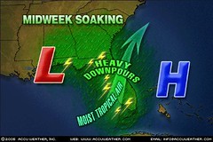
Scattered showers and storms will pockmark the Northeast tomorrow as moisture from the Deep South slathers the region.
June 29: (The Weather Channel)
Northeast
The stormy day experienced by many on Wednesday (June 29) will continue on into Thursday in some form or another. A cold front will move north to south across the region throughout the day. As it clashes with a deep tropical moisture feed showers and storm will spark, primarily along the coast, from the Megalopolis to the Delmarva Peninsula.
Forecast
June 25-27, 2005:
High heat and storms containing dangerous winds, hail, and/or tornadoes focus on eastern Texas, the ArkLaTex region, and northward.
Results
High heat plagued the area.No dangerous storms reported over eastern Texas or the ArkLaTex region. Torrential rains were reported farther to the north over Iowa and Wisconsin. See below.
June 25: (The Weather Channel)
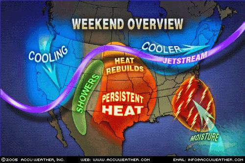
Areas from Texas through the Mississippi Valley will continue to deal with hot temperatures and virtually no rainfall on Saturday or through the weekend for that matter.
Training thunderstorms along a line from Sioux City, Iowa towards Madison, Wisc. produced torrential rainfall late Friday night and early Saturday morning. Radar-estimated rainfall shows that portions along the northern tier of Iowa picked up anywhere from 3" to possibly more than 8" of rain obviously resulting in road and field flooding.
June 27: (The Weather Channel)
The Mississippi River will continue to be a demarcation line in the South tomorrow: scattered showers and thunderstorms to the east, hot and dusty to the west.
Forecast
June 24-27, 2005:
A lower range of temperatures and atmospheric disturbances affect the western US through the Great Basin area then continue eastward over the Rockies.
Results
June 23:
Weather Map courtesy of Accuweather.com
June 25: (The Weather Channel)
West
A number of disturbances aloft will trigger scattered thunderstorms across much of the West for a while. Look for a few afternoon showers over parts of western sections of Washington and Oregon today. Lightning will continue to threaten more fires. Temperatures will be average or slightly below over the weekend and 5 to 15 degrees below average in the Pacific Northwest by Monday.
June 26: (The Weather Channel)
West
The upper-level disturbance that has brought severe thunderstorms to the northern and central Rockies will bring more thunderstorms today over the northern Rockies. Widely scattered thunderstorms will also redevelop over the Four Corners' states.
Forecast
June 24-27, 2005:
A La Niña event may become apparent around this time.
Results
EL NIÑO/SOUTHERN OSCILLATION (ENSO)
DIAGNOSTIC DISCUSSION
issued by
CLIMATE PREDICTION CENTER/NCEP
June 9, 2005
Spanish Version (Español -- Courtesy of INFOCLIMA, Peru)
Synopsis: ENSO-neutral conditions are expected during the northern summer and fall (June-November) 2005.
Forecast
June 24-27, 2005:
A major storm system affects the Northeast and New England. Most likely a good amount of moisture is drawn northward triggering storms and rain. A tropical system cannot be ruled out. In some cases, the initial reaction appears in the form of a strong high pressure system bringing high heat that then erupts in storms.
Results
No "major storm" reported, but high heat and tropical moisture were evident.
June 25: (The Weather Channel)
Northeast
A cold front will sluggishly approach the Northeast today out of Canada however it’s not the cool air behind the front that we’ll be talking about but rather the high heat and humidity ahead of the front that will be the big story. Westerly winds pouring out of the steamy Midwest will transport that hot and humid air mass into Southern New England. This factor along with compressional heating (downsloping winds) will allow the mercury to soar into the mid to upper 90s throughout many cities of New England. You won’t escape the heat elsewhere as one can anticipate highs in the middle 90s from New York City to Washington, D.C.
June 26: (The Weather Channel)
Northeast
Northeast
Scattered showers and storms will pockmark the Northeast tomorrow as moisture from the Deep South slathers the region. The precipitation and attendant cloudiness will help ameliorate temperatures (highs in the 70s and 80s), but the air mass will be tropically oppressive.
A broad upper low can be found hovering over the northern Gulf today and will creep northward over the next two to three days towards the Mid-Atlantic. Plus, as is the case in the Northeast, the Bermuda High will usher in a very tropical air mass originating from the Caribbean and the Gulf.
Forecast
June 22-23, 2005:
The potential for storms producing damaging winds, hail, and tornadoes etc. are shown over the Mississippi Valley area.
Results
June 22: (The Weather Channel)
A disturbance rolling across southern Canada above the ridge will set off thunderstorms that could dive southeastward into the northern parts of the Upper Midwest tonight. These storms could become strong to severe. The threat will extend across parts of North Dakota and northern Minnesota. In addition, a few isolated thunderstorms are possible around the mid-Mississippi Valley.
June 23: (The Weather Channel)
The approaching cold front will set off showers and storms, some severe, from the eastern Dakotas through Minnesota during the afternoon and evening. The threat stretches along the I-29 corridor (between Grand Forks, N.D. and Sioux Falls, S.D.) and eastward into the Arrowhead of Minnesota. A few tornadoes are possible but the real threats are very large hail and damaging wind gusts on the order of 60 to 70 mph.
Forecast
June 22-23, 2005:
A warm and moist air mass is drawn up over the Southeast and Mid-Atlantic States creating unsettled conditions over the region.
Results
June 22: (The Weather Channel)
Showers and storms will once again threaten the already soggy Sunshine State. Tropical moisture will continue to funnel across the southern portion of the state. The weakening upper-level through may once again aid in developing a few showers and thunderstorms during the afternoon from the Carolinas to coastal Georgia.
Northeast
Showers and thunderstorms could dampen part of the day along the I-95 corridor as a cold front marches through the region. Severe storms are not expected and most will remain isolated to scattered.
June 23: (The Weather Channel)
South
It is the same old story across the South, more rain for South Florida and poor air quality for many. Isolated thunderstorms may also dampen part of the day across northern Florida, south Georgia and the coastal Carolinas. Meanwhile, hot and sunny weather will dominate from the Tennessee Valley to the Southern Plains. Highs will reach the 80s across the Southeast and well into the 90s from the Tennessee Valley to the Southern Plains.
Northeast
Picture perfect weather is in store across the Northeast as high pressure builds in behind Wednesday’s cold front. Comfortable humidity will accompany the sunshine. Highs will range from the 70s across New York state and New England to the 80s across the Mid-Atlantic. As the weekend nears, temperatures will climb into the 80s and 90s and the mugginess will return region-wide.
Forecast
June 20-22, 2005:
A storm system is indicated over the Northeast and New England at this time. This is most likely the continuation of the weather system referred to in the June 17-19 forecast.
Results
June 22: (The Weather Channel)
Northeast
Showers and thunderstorms could dampen part of the day along the I-95 corridor as a cold front marches through the region. Severe storms are not expected and most will remain isolated to scattered.
Weather map courtesy of The Weather Channel
Forecast
June 17-19, 2005:
A weather pattern bringing strong winds is indicated for the eastern US. This may take the form of a tropical storm or hurricane if formation took place in the Gulf or over the Florida Keys. In such a case, it could now make landfall along the Florida Panhandle or peninsula. If not an actual tropical system, then storms triggering tornadoes or other windy conditions are possible throughout the Southeast and Ohio Valley.
Results
June 18: (The Weather Channel)
South
Conditions will deteriorate by late Saturday across parts of Virginia and the Carolinas as low pressure develops aloft. Some thunderstorms could turn severe with hail and damaging wind gusts the priority threats. Showers and thunderstorms will redevelop on Sunday across the Carolinas, Georgia and Florida. On Monday, the upper-level low will still be stuck over the Southeast resulting in more showers and thunderstorms over coastal North Carolina, South Carolina, Georgia, Alabama and Florida.
June 19: (National Weather Service)
THIS HAZARDOUS WEATHER OUTLOOK IS FOR SOUTH FLORIDA, LAKE
OKEECHOBEE, AND ADJACENT COASTAL WATERS.
.DAY ONE...TODAY AND TONIGHT
THUNDERSTORMS: NUMEROUS THUNDERSTORMS ARE EXPECTED TO DEVELOP OVER
THE EASTERN METROPOLITAN AREAS BY LATE THIS AFTERNOON. THE MAIN
THREATS FROM THESE STORMS WILL BE FREQUENT LIGHTNING...SOME WIND
GUSTS TO 40 TO 45 MPH AND HEAVY RAIN CAPABLE OF PRODUCING
LOCALIZED FLOODING.
.DAYS TWO THROUGH SEVEN...MONDAY THROUGH SATURDAY
HEAVY RAINFALL CAN OCCUR WITH SHOWERS AND THUNDERSTORMS AS DEEP
TROPICAL MOISTURE WILL STILL BE IN PLACE OVER SOUTH FLORIDA. THIS
COULD LEAD TO THE POTENTIAL URBAN FLOODING PROBLEMS ACROSS SOUTH
FLORIDA FOR MONDAY (June 20).
Forecast
June 18-20, 2005: More moisture and heat are indicated from southern Texas northward through the Plains. This could cause storms to erupt since ample Gulf moisture will most likely be available.
Results
June 18: (The Weather Channel)
Look for increasing temperatures across the Plains over the weekend and than spreading into the Ohio Valley and Great Lakes region by Monday and Tuesday. Look for 80s all the way through the Dakotas and by Sunday, 90s will find their way into parts of Kansas, Nebraska and western Missouri. A peak into the future shows this heat may be here to stay for much of the upcoming week and unfortunately humidity will be on the increase making for sweltering conditions.
Areas west of the Mississippi, especially Texas, will have to deal with summertime heat into next week.
June 19: (The Weather Channel)
Warmer temperatures and additional moisture will continue across much of the Midwest today. Sunny skies will be seen from Denver to Chicago as high pressure keeps skies clear...However, a few scattered thunderstorms will make their way through the Dakotas and into northern Minnesota today as a disturbance moves through the region.
The string of 90 degree days in Dallas will continue today with an afternoon high in the mid 90s. Houston and New Orleans will also see plenty of sunshine today with high temperatures reaching into the 90s.
June 20: (The Weather Channel)
Temperatures across the Northern Plains and Upper Midwest will soar to levels around 10 degrees above average for this time of the year. This translates into afternoon highs in the 80s and 90s for most. You will have to travel to the lakeshores of the Great Lakes to find temperatures in the 70s. Showers and storms may provide brief relief from the warm temperatures across areas form the U.P. of Michigan back through the Dakotas. A few storms may also become strong to severe. Elsewhere, sunshine will be widespread.
Forecast
June 14-16, 2005: Incoming moisture from the Gulf sets off thunderstorms from the Mississippi Valley eastward across the Southeast, Ohio Valley, and Mid-Atlantic States.
Results
June 14, 2005: (The Weather Channel)
The greatest threat today for severe thunderstorms will extend from the Great Lakes through the Ohio Valley. Large hail, damaging winds and even tornadoes are possible, especially across Ohio.
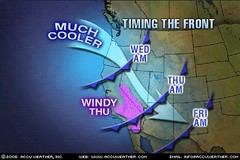
June 16, 2005: (The Weather Channel)
Northeast
The heat and oppressive humidity buster has finally made a move through the whole Northeast region. Areas that dealt with yet another hazy, hot, and humid day on Wednesday (eastern Pa., N.J., Del., Md., and Va.) will finally get a sample taste of the cooler conditions that others in the region have already experienced earlier this week...With and upper low overhead (cooler air aloft), this will allow for the building of afternoon instability showers and embedded thunderstorms throughout the entire Northeast region.
Forecast
June 14-16, 2005: Certain weather models indicate storms along the length of the East Coast from Florida to Maine.
Results
No storms from Florida to Maine but a cold front.
Weather map courtesy of the Weather Channel
Forecast
June 14-16, 2005: Tropical Storm formation may be possible in the Gulf around 86 West longitude and 26 North latitude, as well as in the area between the Florida Keys and Cuba.
Results
June 14-16, 2005: No tropical storm formation near 86 West longitude and 26 North latitude.
June 15, 2005: (The Weather Channel)
Pulsing thunderstorms in the north-central Caribbean Sea continue to be monitored for signs of better organization...Although organization in the disturbance is minimal, heavy tropical downpours across Jamaica, extreme eastern Cuba, Haiti and the Dominican Republic are expected to continue.
Forecast
June 13-15, 2005: Cold, dry air invades the Rockies with the strong possibility of triggering storms and/or windy conditions over the Front Range.
Results
URGENT - WEATHER MESSAGE
NATIONAL WEATHER SERVICE CHEYENNE WY
348 AM MDT TUE JUN 14 2005
THE NATIONAL WEATHER SERVICE IN CHEYENNE HAS CANCELLED THE FROST
ADVISORY FOR THE LARAMIE VALLEY. PATCHY AREAS OF FROST MAY
OCCUR...BUT WIDESPREAD FROST IS NOT EXPECTED THIS MORNING.
REGIONAL WEATHER SUMMARY FOR THE HIGH PLAINS
NATIONAL WEATHER SERVICE GOODLAND KS
230 PM MDT MON JUN 13 2005
STRONG WINDS FROM THE WEST TO NORTHWEST DOMINATED AREAS NORTH OF INTERSTATE 70.
WEATHER SUMMARY FOR NEW MEXICO
NATIONAL WEATHER SERVICE ALBUQUERQUE NM
530 AM MDT MON JUN 13 2005
ALONG THE EAST SLOPES OF THE CENTRAL MOUNTAIN
CHAIN...PERIODS OF BREEZY CONDITIONS WERE NOTED BEFORE MIDNIGHT. A
COLD FRONT PUSHED DEEP INTO THE EASTERN PLAINS OVERNIGHT AND
EVENTUALLY SQUEEZED THROUGH INTO THE CENTRAL VALLEYS JUST BEFORE
SUNRISE INCREASING LOW LEVEL MOISTURE AND PROVIDING BREEZY TO WINDY
CONDITIONS IN THE NORMALLY FAVORED EAST CANYON WIND AREAS.
Forecast
June 13-15, 2005: Windy weather is likely through the West Coast States as well.
Results
June 15, 2005: (The Weather Channel)
Coastal areas of the Pacific Northwest will be cloudy and cool and this trend will last into the weekend with increasing amounts of rain (and strong coastal winds) by tomorrow (June 16) as a potent Pacific storm approaches.
SPECIAL WEATHER STATEMENT
NATIONAL WEATHER SERVICE RENO NV
502 AM PDT WED JUN 15 2005
AN UNSEASONABLY STRONG LOW PRESSURE SYSTEM IS HEADED TO
A POSITION OFF THE SOUTHERN OREGON COAST BY THURSDAY. STRONG
SOUTH TO SOUTHWEST WINDS WITH GUSTS TO NEAR 50 MPH IN THE VALLEYS
AND 100 MPH ALONG THE SIERRA CREST WILL DEVELOP THURSDAY (June 16) AFTERNOON
AND EVENING AHEAD OF AN APPROACHING COLD FRONT.
URGENT - WEATHER MESSAGE
NATIONAL WEATHER SERVICE MEDFORD OR
345 AM PDT WED JUN 15 2005
...A HIGH WIND WATCH IS IN EFFECT FROM THURSDAY MORNING (June 16) TO THURSDAY
AFTERNOON FOR THE HEADLANDS...
Forecast
June 12, 2005: Around this time the storms shown over the Front Range and Texas should arrive over the Mississippi Valley and continue eastward.
Results
June 12, 2005: (The Weather Channel)
Remnants of Arlene push northward
The National Hurricane Center issued the final advisory at 11:00 p.m. EDT on Saturday for Tropical Depression Arlene. Arlene came ashore around 4 p.m. EDT between Mobile and Pensacola as a Tropical Storm...Bands and areas of rain continue over parts of southern Indiana and Illinois, Kentucky, Tennessee, northeastern Mississippi, Alabama, Georgia, and Florida.
Forecast
June 7-11, 2005:
Two areas slated for severe weather may actually indicate tropical storm or hurricane formation since June begins hurricane season. The first is the area around Brownsville, Texas and the other lies in the southeastern Gulf at around 86 West longitude and 24 North latitude.
Results
June 8, 2005 (National Weather Service)
TROPICAL DEPRESSION ONE FORECAST/ADVISORY NUMBER 1
NWS TPC/NATIONAL HURRICANE CENTER MIAMI FL AL012005
2100Z WED JUN 08 2005
TROPICAL DEPRESSION CENTER LOCATED NEAR 17.2N 84.0W AT 08/2100Z
POSITION ACCURATE WITHIN 60 NM
PRESENT MOVEMENT TOWARD THE NORTH OR 360 DEGREES AT 6 KT
ESTIMATED MINIMUM CENTRAL PRESSURE 1004 MB
MAX SUSTAINED WINDS 25 KT WITH GUSTS TO 35 KT.
June 10, 2005 (National Weather Service)
TROPICAL STORM ARLENE ADVISORY NUMBER 11
NWS TPC/NATIONAL HURRICANE CENTER MIAMI FL
10 PM CDT FRI JUN 10 2005
AT 10 PM CDT...0300Z...THE CENTER OF TROPICAL STORM ARLENE WAS
LOCATED NEAR LATITUDE 27.1 NORTH... LONGITUDE 86.1 WEST...
(No tropical storm or hurricane formation reported near Brownsville, TX)
Forecast
June 7-11, 2005:
A major weather pattern develops over the Front Range and Texas. Tropical heat and moisture flow northward from the Gulf increasing temperatures and unleashing severe storms with tornado potential. Storms push eastward through the Mississippi Valley.
Results
June 8, 2005: (The Weather Channel)
Severe storms seem most likely over southwestern Nebraska, eastern Colorado, and western Kansas.
June 10, 2005: (The Weather Channel)
The other trouble spot is in the southern Plains. Severe storms will once again pelt parts of Oklahoma and western Texas this weekend as disturbances continue to parade out of the West. Locally large hail, damaging wind gusts, a few tornadoes and torrential downpours will accompany any developing thunderstorms.
More strong storms will fire Saturday afternoon (June 11) in the same hard hit areas of the central Plains, namely Kansas and Nebraska, forming yet another complex of heavy rain-producing storms.
Forecast
June 4-7, 2005:
In the main, fair weather is indicated over the western States and the Rockies at this time. The exception seems to be the Pacific Northwest where the chance of some unsettled weather exists.
Results
June 5, 2005: (The Weather Channel)
An upper-level trough digging into the Northwest will keep things rather cool and unsettled today and Monday. High temperatures will hover in the upper 50s to near 60 degrees in both the Seattle and Portland areas.
Forecast
June 4-7, 2005:
The Mississippi Valley and East Central area should have fine weather, although the storms in the Plains may begin to move eastward.
Results
June 5, 2005: (The Weather Channel)
A strong upper-level system combining with plenty of low-level moisture erupted into a severe weather outbreak on Saturday. There were around 40 reports of tornadoes with numerous other reports of large hail and damaging winds. A cluster of strong storms even did damage in the Chicago metro area. The upper-air disturbance causing the severe weather will shift east today bringing the threat of severe storms to Wisconsin and Michigan southwestward into Missouri. These storms will have the potential to produce large hail, damaging winds and a few tornadoes.
Forecast
May 31-June 3, 2005:
A windy storm breeding pattern is slated to affect the Rockies, Great Basin, and West Coast States. Besides erratic gusty winds, this pattern is usually accompanied by sharp dips in temperature and scattered severe thunderstorms.
Results
May 31, 2005: (The Weather Channel)
As one storm system exits the West, a new one will move in...Meanwhile, another system will move into the Pacific Northwest...Showers will become more widespread across the region heading into Wednesday, as a deep trough develops across the Northwest. Along with the showers, this storm will also bring in cooler weather as well.
(National Weather Service)
A COLD FRONT WILL MOVE THROUGH EASTERN WASHINGTON AND OREGON THIS
MORNING. WINDS WILL BECOME BREEZY TO WINDY ACROSS THE COLUMBIA BASIN
...COLUMBIA RIVER GORGE...AND KITTITAS VALLEY BEHIND THE FRONT.
THESE WINDS WILL RAISE PATCHY BLOWING DUST ACROSS THE COLUMBIA BASIN
LATER TODAY.
Courtesy of Accuweather
Forecast
May 31-June 3, 2005:
Meanwhile over the Texas and the Plains, warm moist air is drawn northward and will react with the colder, drier air over the Rockies. This combination should ignite severe storms over the Front Range, Texas, and the Plains. Tornado activity is a distinct possibility.
Results
May 31, 2005 (The Weather Channel)
A potent storm system brought severe weather to the High Plains Monday evening. Hail to the size of baseballs fell eastern New Mexico, with tornadoes being spotted in eastern New Mexico and southeastern Colorado. This storm system will emerge into the Central Plains during the day on Tuesday, taking its severe thunderstorms with it. Showers and thunderstorms are dampening the region from western Nebraska into the Texas Panhandle this morning...Severe thunderstorms are possible across southeastern Nebraska, Kansas, Oklahoma, and northern Texas. While large hail and damaging winds will be the primary threat, an isolated tornado cannot be ruled out. As this system pushes eastward, residents of Kansas City, Tulsa, and Dallas will need to keep an eye out for thunderstorms late today and overnight.
June 5, 2005: (The Weather Channel)
A strong upper-level system combining with plenty of low-level moisture erupted into a severe weather outbreak on Saturday (June 4). There were around 40 reports of tornadoes with numerous other reports of large hail and damaging winds. A cluster of strong storms even did damage in the Chicago metro area.
Forecast
June 1-4, 2005:
The East Central States and Southeast will also see an invasion of colder air triggering storms throughout the region. Potentially dangerous atmospheric conditions are indicated over Florida, especially along the west coast. The storms over the East Central States work their way over New England.
Results
May 31, 2005 (The Weather Channel)
It will be yet another day of clouds, showers, and scattered thunderstorms across the Southeast today. The heaviest rain this morning will overspread the Florida Peninsula, where Tampa and Orlando could pick up over an inch of rain. Thunderstorms are also possible along the Gulf Coast from the Florida Panhandle to Louisiana. Showers are more likely farther north across Mississippi, Alabama, and Georgia.
(Accuweather)
A slowly moving storm and a very humid flow of air from the tropics will continue to bring drenching downpours to Florida the next couple of days. Already, places like Tampa have had over 2 inches of rain and more is on the way. The conveyor belt of moisture could easily produce rainfall totals in excess of 4 inches in some areas by Friday.
No comments:
Post a Comment