Click here for the Introduction to The Weather Alternative
Forecasters are just now becoming aware of the storm potential developing over the Rockies and Plains. The Weather Alternative forecast (see below), crafted last December and January and published in the July issue of Dell Horoscope, pinpointed the developing weather systems months ago.
Oct 15-18, 2006
Abundant moisture is also drawn up over the Plains creating severe weather potential along the Front Range of the Rockies.
Accuweather reports the following:
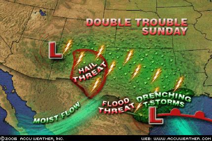
Another system - an upper-level low, will move across Arizona today spreading plenty of moisture northeastward into New Mexico and the western half of Texas. This will lead to thunderstorms as well across this area. Given
the proximity of the upper-level low and its associated cold pool of air aloft, stronger thunderstorms in this area will have the risk for hail in them.
 The Next Cold Shot
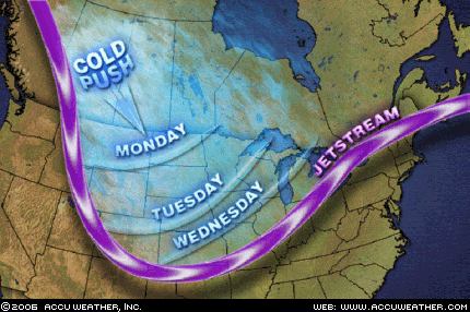
One nice thing about fall is it is a season in
transition. If you don't like the weather at one point, give it time, and it will change. That will happen the middle of this week across the northern Rockies and much of the Midwest as the next shot of cold air is released. This air mass will not be quite as cold as its predecessor, but will still be cold enough to drop temperatures back downwards significantly and also set the stage for another winter storm from Montana to the Colorado Rockies and into the Dakotas and western Nebraska, come Tuesday (17th) and Wednesday (18th).
No comments:
Post a Comment