 The Weather Alternative forecast for the St. Patrick's Day week was posted on November 17, 2009. The forecast called for penetratingly cold air to descend over the Mississippi Valley and Great Lakes on gusty winds easily reaching the central and eastern Gulf Coast States between the 13th and the 17th of March.
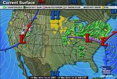
The weather activity started on the 12th with a a storm system over the Ohio Valley and Southeast that brought heavy rain and strong winds, which then moved into the Northeast on the 13th. The only thing missing that was called for in the forecast was penetratingly cold air. The gusty winds were present. The Weather Channel map at left is for March 13th.
I offered two scenarios in the forecast. The first scenario called for the cold air to bring a high pressure system all the way down to the Gulf Coast. The second scenario called for the cold air mass to bring significant precipitation in the form of a low pressure system and strong winter storm.
The actual weather resembled the second scenario more than the first. Significant precipitation was experienced in the form of heavy rain--first over the Mid-Mississippi Valley, Great Lakes, and Ohio Valley on the 12th, then three to four inches of rain on the 13th from New Jersey to Southern New England. The rain produced localized flooding, while the winds helped in producing dangerous surf, coastal flooding, and beach erosion. On the 13th and 14th, freezing rain was expected in parts of New England, and sleet and snow was forecast for the Adirondacks of New York. I thought we might see lake-effect snows over the Great Lakes, but it was not cold enough to produce snow there.
This weather event was billed as a major storm by conventional forecasters, while I called it a strong winter storm.
Blustery conditions and light showers continued over the Northeast and New England on the 16th.
For the St. Patrick's Day Parade in New York City, I mentioned that there would be a chance of rain, but the storm system had cleared the area by then.

United Kingdom
March 13-17, 2010
The forecast for the United Kingdom was for a cold air mass to work its way southward and eastward over the United Kingdom with windy conditions and precipitation likely.
The Accuweather map at right is for March 13th. High pressure west of Ireland brought a chilly northerly flow that resulted in showers and breezy conditions on the 13th and 14th. Showers lingered over northern portions on the 15th, and by the 16th and 17th fair conditions were experienced.
Introduction to the Weather Alternative
How Long-Range Forecasts Are Made
Can We Say We've Suffered?
If we are not in the way of His blessings, then would you like to go home and see why, and how you can get back and get those blessings? Friend, you live in the miserablest place on Earth, Great Britain. You’re the biggest lot of grumblers there is. And you’ve got nothing to grumble about, may God challenge you! Do you realize how many hungry people there are in India tonight? Have you ever been hungry? Do you realize how many people still live in refugee camps? Have you ever lived in a refugee camp? Do you know how many people live under the iron hand of communism? Have you ever lived under the iron hand of communism? Have you ever lived through an earthquake, like Turkey is right now? Do you know anything about a typhoon? Do you know anything about an enemy soldier standing in front of you, and you’re a woman? Do you? Of course you don’t. Do you think you know anything? No! You don’t know sorrow, you don’t know suffering. May God break your hearts, and through those breaking hearts pour His love. --Gladys Aylward Missionary to China, Mother to 100 orphans
1 comment:
Hi Ken, would you please update your link for Astrological Musings/Astrodynamics? It's www.astrodynamics.net/blog. Thanks!
Lynn
Post a Comment