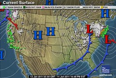
At the end of December, The Weather Alternative forecast warned of an invasion of cold air, a low pressure system, and high wind warnings to affect the Great Lakes, the Pacific Northwest, and the Northeast between January 10-13, 2011.


The above Weather Channel map for today, January 11th, shows the three storm systems as predicted. The storm system over the Great Lakes has dropped 3 to 6 inches of snow and is currently producing winds of 25 to 30 mph.
Meanwhile, a major snowstorm is in the making over the Northeast. Conventional meteorologists foresee 6 to 10 inches of snow across New Jersey, and about a foot of snow in the lower Hudson Valley and New York City. Long Island may see over a foot of snow. When factoring in the wind, which could gust as high as 50 mph in New England, forecasters are expecting blizzard conditions there as well as over Long Island.
The Northwest is no exception. A disruptive winter storm, tonight into tomorrow, could bring 1 to 3 inches of snow to Seattle, which is an unusual occurrence. High wind warnings are in effect for the Pacific Northwest coast as 30 to 40 mph winds and gusts up to 60 mph affect the area.
January 25-27, 2011 New England and Eastern Canada
South Texas Wet Weather Feb 16-18, 2011
Significant West Coast Storm February 20-23, 2011
Major Storm January 3-5, 2011
Midwest Winter Cold and Heating Oil
Tropical Storm Matthew Fulfills Long-range Forecast!
Hurricane Earl and T.D. 10E Fulfill Long-range Forecasts!
Tropical Storm Alex Fulfills Long-range Prediction!
Bonnie Fulfills Long-range Forecast!
Introduction to the Weather Alternative
How Long-Range Forecasts Are Made
Global Warming and Recent Weather

No comments:
Post a Comment