At the end of March, I posted a long-range forecast for April 18-24, 2011. The forecast zeroed in on areas that might experience "wild weather." Three areas were highlighted: Puerto Rico, the area from Northwest Texas through Tennessee and Georgia, and area about 600 miles off the coast of California.
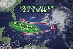
As can be seen from the above Accuweather map of April 21, conventional meteorologists were watching a low-pressure system about 460 northeast of San Juan, Puerto Rico. Forecasters were concerned that it might develop tropical characteristics. The low lingered in the area and by the 23rd, the National Weather Service issued its last advisory on the low pressure.
The next area for wild weather was from Northwest Texas through Tennessee and Georgia.
This was a very volatile time for this section of the States. Prior to the forecast period there were already deadly tornadoes. Within the April 18-24 window there were violent thunderstorms that hit central Texas to northern parts of Mississippi, Alabama and Georgia. There were reports of damaging winds and hail.
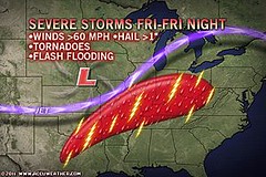
The above map is for the 22nd and shows the area slated for severe storms, tornadoes, and flash flooding. This is roughly the same area I pinpointed in my long-range forecast. The St. Louis airport was hit by a tornado.
As can be seen from the above Accuweather map of April 21, conventional meteorologists were watching a low-pressure system about 460 northeast of San Juan, Puerto Rico. Forecasters were concerned that it might develop tropical characteristics. The low lingered in the area and by the 23rd, the National Weather Service issued its last advisory on the low pressure.
The next area for wild weather was from Northwest Texas through Tennessee and Georgia.
This was a very volatile time for this section of the States. Prior to the forecast period there were already deadly tornadoes. Within the April 18-24 window there were violent thunderstorms that hit central Texas to northern parts of Mississippi, Alabama and Georgia. There were reports of damaging winds and hail.
The above map is for the 22nd and shows the area slated for severe storms, tornadoes, and flash flooding. This is roughly the same area I pinpointed in my long-range forecast. The St. Louis airport was hit by a tornado.
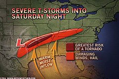
The above Accuweather map is for the 23rd and shows roughly the same area that I had specified. Severe weather continued to threaten the area.
The 3rd area mentioned in the forecast was 600 miles off the coast of California. I was unable to verify either way if a low developed there or not.
Hurricane Season 2011 Predictions
April 18-24, 2011 Severe Weather Window
Overview of UK Winter 2012-13
The Winters of 2011-14
Cyclone Yasi fulfills long-range prediction!
Tropical Storm Matthew Fulfills Long-range Forecast!
Hurricane Earl and T.D. 10E Fulfill Long-range Forecasts!
Tropical Storm Alex Fulfills Long-range Prediction!
Bonnie Fulfills Long-range Forecast!
Introduction to the Weather Alternative
How Long-Range Forecasts Are Made
Excerpts from Tidal Dynamics by Fergus J. Wood
Alistar McGrath on the New Atheism
No comments:
Post a Comment