The next forecast that appeared in the Feb/Mar 2012 edition of The Mountain Astrologer covered the Feb 7-9 period. These forecasts were elaborated in July of 2011 about 7 months ago.
Here are the results.
Forecast
February 7-9, 2012
This three-day stretch features a Sun-Mercury conjunction, Saturn's retrograde station, and the conjunction and parallel of Venus with Uranus. Each of these is a cold-weather breeder. Stateside, these planetary influences congregate over the 79th degree of west longitude through the Northeast, Mid-Atlantic, and Southeast and promise wintry precipitation and cold temperatures.
Results
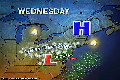
On the 8th, a storm system brought some light snow to the Mid-Atlantic, Northeast, and some rain to the northern parts of the Southeast as shown in the Accuweather map below.
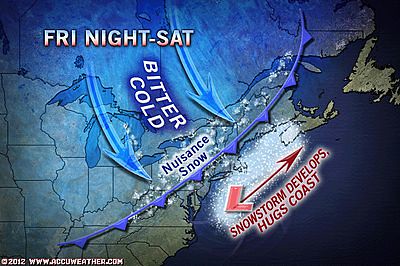
But the cold indicated by these planetary alignments took an extra day to really kick in. Accuweather reported that on the 10th an arctic cold front would aggressively roll into the Great Lakes, Northeast, and New England and develop a coast storm bringing snow from the Delmarva through New England.
Forecasts were also issued for Europe and China.
Forecast
February 7-9, 2012
Uranus occupies the 8th degree of east longitude through Germany and Switzerland. The surrounding areas will get a shot of winter wind and snow. Winter weather is indicated through central and eastern China.
Results
Here are the results.
Forecast
February 7-9, 2012
This three-day stretch features a Sun-Mercury conjunction, Saturn's retrograde station, and the conjunction and parallel of Venus with Uranus. Each of these is a cold-weather breeder. Stateside, these planetary influences congregate over the 79th degree of west longitude through the Northeast, Mid-Atlantic, and Southeast and promise wintry precipitation and cold temperatures.
Results
On the 8th, a storm system brought some light snow to the Mid-Atlantic, Northeast, and some rain to the northern parts of the Southeast as shown in the Accuweather map below.

But the cold indicated by these planetary alignments took an extra day to really kick in. Accuweather reported that on the 10th an arctic cold front would aggressively roll into the Great Lakes, Northeast, and New England and develop a coast storm bringing snow from the Delmarva through New England.

Forecasts were also issued for Europe and China.
Forecast
February 7-9, 2012
Uranus occupies the 8th degree of east longitude through Germany and Switzerland. The surrounding areas will get a shot of winter wind and snow. Winter weather is indicated through central and eastern China.
Results
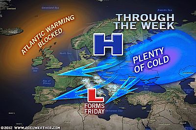
During this time, Europe found itself in the midst of a continuing cold wave with temperatures 10 to 20 degrees below normal. The 7th brought windy and unsettled conditions throughout the Mediterranean with gales and heavy showers. On the 9th snow was reported in central Germany, Austria, Hungary, and Switzerland. As seen on the Accuweather map below, Friday, the 10th, brought the development of a low pressure area over Italy bringing snow there and eastward.

As for China, according to the China Meteorological Administration the 7th brought a temperature drop of 6 to 8 degrees in south China with windy conditions. The 8th brought light to moderate snow with isolated heavy snow to parts of southern China. From Feb.9 to 10, freezing rain was forecast to hit central and western Guizhou.
Winter 2011-12 The Rockies
Winter 2011-12 West Coast
Hurricane Season 2011 Forecast Results
Hurricane Risk-Management
Update on Winter 2011-12
Texas Summer 2012
New Weather Alternative Website
Overview of UK Winter 2012-13
The Winters of 2011-14
Fulfilled Long-range Forecasts for Hurricane Season 2010
Contraception Rule

No comments:
Post a Comment