Here are the results of the last of the long-range weather forecasts that appeared in the Feb/Mar 2012 edition of The Mountain Astrologer magazine. The forecasts were prepared in July of 2011.
Forecast
March 17-19, 2012
Mercury, now retrograde, will make one more swipe at Uranus by conjunction. A retrograde Mercury increases wind speeds and with Uranus those winds are cold. Winter precipitation usually is part of the deal. The eastern third of the country is affected as is the Plains and the Pacific Northwest. Central Europe should see a windy low pressure area and cold, windy conditions should affect Russia down through central China.
Results
Plains

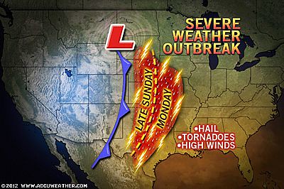
The above Accuweather map depicts the severe weather experience over the Plains during the forecast period. The post that accompanied the above map read Plains Violent Storm, Tornado Threat Begins Sunday (18th)
Eastern U.S.
The eastern U.S. actually experienced a warm up as seen from the weather headlines below along with a backdoor cold front.
March 16th- Accuweather - Locally Strong Storms in the South This Evening
March 17- Accuweather - a backdoor cold front that slowly pushed to the east brought cooler air to the Northeast and coastal mid-Atlantic. But- Warmth returns to New England and coastal Mid-Atlantic.
West Coast

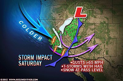
It was a wild ride for the U.S. West Coast. The above Accuweather map depicts conditions on the 17th. Here's what Accuweather reported: While the storm will deliver a substantial amount of rain and snow to the region that is greatly needed, it will bring high winds, blowing dust, thunderstorms, chilly air and rough surf and seas. The storm may also bring flash flooding, power outages and a rash of motor vehicle accidents.
Forecast
March 17-19, 2012
Mercury, now retrograde, will make one more swipe at Uranus by conjunction. A retrograde Mercury increases wind speeds and with Uranus those winds are cold. Winter precipitation usually is part of the deal. The eastern third of the country is affected as is the Plains and the Pacific Northwest. Central Europe should see a windy low pressure area and cold, windy conditions should affect Russia down through central China.
Results
Plains

The above Accuweather map depicts the severe weather experience over the Plains during the forecast period. The post that accompanied the above map read Plains Violent Storm, Tornado Threat Begins Sunday (18th)
Eastern U.S.
The eastern U.S. actually experienced a warm up as seen from the weather headlines below along with a backdoor cold front.
March 16th- Accuweather - Locally Strong Storms in the South This Evening
March 17- Accuweather - a backdoor cold front that slowly pushed to the east brought cooler air to the Northeast and coastal mid-Atlantic. But- Warmth returns to New England and coastal Mid-Atlantic.
West Coast

It was a wild ride for the U.S. West Coast. The above Accuweather map depicts conditions on the 17th. Here's what Accuweather reported: While the storm will deliver a substantial amount of rain and snow to the region that is greatly needed, it will bring high winds, blowing dust, thunderstorms, chilly air and rough surf and seas. The storm may also bring flash flooding, power outages and a rash of motor vehicle accidents.
Europe
Some degree of windiness was experienced in Europe as shown below.
Mar 17- Windy across Scandinavia down into eastern Europe today.
Mar 19- Fine for much of Europe, but rain and stronger winds to the north
China
The China Meteorological Administration issued a Blue Warning on the 17th for "Gale and Dropping Temperatures."
On the 18th they reported the following- Liaoning will get 12 to 14 degree Celsius dropping with 4 to 5 northerly winds. There will be 7 to 9 scale of northerly winds in the Bohai Sea, central and northern the Yellow Sea. The dust or dust blowing will affect South Xinjiang Basin and western Gansu.
Winter 2011-12 The Rockies
Hurricane Season 2011 Forecast Results
Hurricane Risk-Management
Update on Winter 2011-12
Texas Summer 2012
New Weather Alternative Website
Overview of UK Winter 2012-13
The Winters of 2011-14
Fulfilled Long-range Forecasts for Hurricane Season 2010
Introduction to the Weather Alternative

No comments:
Post a Comment