In this post, I'll mention other geographical areas that will be affected each time the eclipse degree is triggered. These times will match with the times mentioned in the first post because those are also based on triggers to the Solar Eclipse degree. So where are these other areas? The areas are circled in the astro-locality map below.
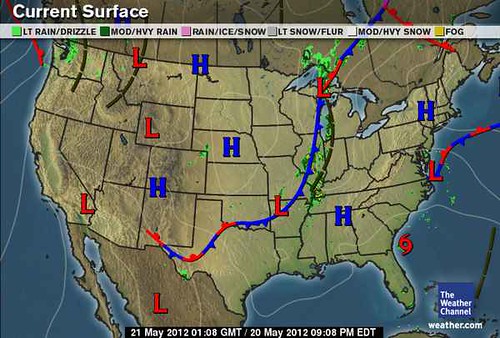
 The circled areas all have one thing in common: they are areas where two planetary lines cross. Probably the most important one is the area over South Carolina because here the crossing is between the two slow-moving, outer planets Jupiter and Neptune. Let's look at the brief history of this crossing. As can be seen in the Weather Channel map below for May 20th (the day of the eclipse), Tropical Storm Alberto formed there the day before.
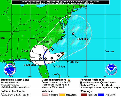
 Then on May 24th, Mercury conjoined the eclipse degree and Subtropical Storm Beryl began to form there as shown in the National Weather Service map below.
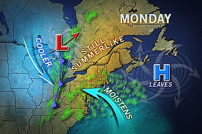
  Similar arguments can be made about the other crossings. For example the crossings over the Mid-Atlantic and Northeast were also active after the eclipse began on the 20th. The map below, for the 21st, shows a cold front setting off storms over that area and moisture being pumped in from--of all places-- the circled area about 350 miles off of South Carolina. Accuweather reported that "The rain and clouds are advancing in from the Atlantic, but that moisture is not associated with Tropical Storm Alberto." When Mercury triggered the eclipse on the 24th, the Mid-Atlantic and Northeast once again experienced showers and thunderstorms.
 The last crossing is the one in the central Caribbean around 80W/17N. This became active around the 24th when Mercury triggered the eclipse degree and generated the beginnings of what is now Subtropical Storm Beryl. On the 25th, the NWS reported " SCATTERED STRONG CONVECTIVE PRECIPITATION...FROM 18N TO THE ATLANTIC OCEAN COAST OF CUBA BETWEEN 78W AND 83W...THIS AREA HAS BEEN CLOUDY AND RAINY FOR THE LAST FOUR TO FIVE DAYS. (That would mean since the time the eclipse took place) ENVIRONMENTAL CONDITIONS ARE EXPECTED TO BECOME MORE CONDUCIVE FOR THE FORMATION OF A SUBTROPICAL OR TROPICAL CYCLONE BY SATURDAY OR SUNDAY.
So in addition to the times and places mentioned in the first post, the following weather patterns should be expected on the dates listed below:
1- Tropical systems to affect the area in and around South Carolina. If not an actual tropical system, the weather pattern may manifest as a subtropical system or as an increase in troipcal moisture being pumped into the region resulting in drenching rains.
2- Thunderstorm activity over the Mid-Atlantic and Northeast.
3- Tropical system development or strong troughs to develop in the central Caribbean area resulting in deep layer moisture and precipitation.
4- The approximate dates in 2012:
June 13-14
August 21-24
September 1-3
October 2-4
October 6-8
October 28-30
November 10-14
November 20-22
Long-range effects of the May 20, 2012 Solar Eclipse
July 14-19, 2012 Hurricane Season Outlook
June 22-30, 2012 Long-range Weather Forecast
June 10-12, 2012 Long-range Weather Forecast
June 4-7, 2012 Long-range Weather Forecast
Hurricane Season 2011 Forecast Results
Hurricane Risk-Management
Texas Summer 2012
New Weather Alternative Website
Overview of UK Winter 2012-13
The Winters of 2011-14
Fulfilled Long-range Forecasts for Hurricane Season 2010
Introduction to the Weather Alternative
Are There Logical Reasons to Believe that God Exists?
No comments:
Post a Comment