The Jupiter-Neptune Square
This aspect is exact on June 24th and 25th and is later triggered again on June 28th. The Solar Ingress chart for the summer season places Neptune along the 101st degree of west longitude which passes through western Texas, along the Front Range of the Rockies, and through the High Plains. Jupiter affects eastern Texas, the central Mississippi River Valley, and the Great Lakes. These are areas that should generally receive above normal precipitation at this time.
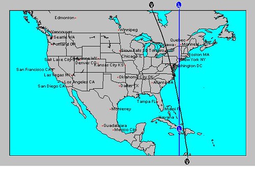
As we look at the combined influence of Jupiter and Neptune in other key charts such as Solar Eclipse charts and New and Full Moon charts, we get some other interesting scenarios. For example, the New Moon chart of June 19th places an important crossing of Jupiter and Neptune in the western Atlantic about emphasizing the area from Haiti northward for about 550 miles as shown in the astro-locality map below.

This area could be the spawning grounds of a tropical system. Since Jupiter and Neptune also affect the coasts of North Carolina and Virginia and continue into the Northeast, the chance exists of a tropical system heading towards those areas at this time. Sometimes it's not an actual tropical system that forms. This configuration can represent the presence of abundant tropical moisture that is pumped up into the area.
As Jupiter perfects its square to Neptune, it will also trigger the Solar Eclipse of November 25, 2011. This will sensitize the 96th degree of west longitude which runs through Dallas, Texas northward into the Plains. Neptune also affects Texas and the Plains. This could argue that tropical moisture from the Gulf of Mexico is pulled northward into Texas pushing its way into the Plains. The mechanism that brings this about could be a low pressure area, front, or even a tropical system in the Gulf.
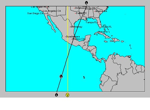
Another interesting scenario develops in the Solar Ingress chart as shown in the astro-locality map below.

Here we see Jupiter and Neptune crossing in the eastern Pacific at 101 west longitude and 10 north latitude or about 550 miles south of the Mexican coast. This indicates the possibility of a tropical system forming around this area now.
The Uranus-Pluto Square
The Uranus-Pluto square is exact on June 24th but is triggered a bit earlier on the 22nd. The Moon will activate it again on the 27th, and finally the Sun will square and oppose them on the 29th. The Solar Ingress chart has them affecting the eastern U.S. and New England. We've already seen that the Jupiter-Neptune configuration affects the East Coast, so this is another influence happening simultaneously.
Two other places that might be worth watching are in and around the state of Mississippi where severe weather could develop and around the 29th about 750 miles west of Cabo San Lucas (121 west/23N) where a tropical system could develop or pass.
June 10-12, 2012 Long-range Weather Forecast
June 4-7, 2012 Long-range Weather Forecast
Hurricane Season 2011 Forecast Results
Hurricane Risk-Management
Texas Summer 2012
New Weather Alternative Website
Overview of UK Winter 2012-13
The Winters of 2011-14
Fulfilled Long-range Forecasts for Hurricane Season 2010
Introduction to the Weather Alternative
No comments:
Post a Comment