Forecast
October 15-19, 2012
Venus and Jupiter make adverse aspects to Saturn, and the Sun parallels Saturn. This represents a cold and stormy time for the Plains.
Results
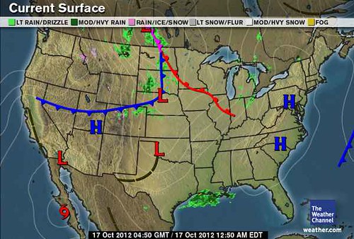
The Weather Channel map below is for Oct 16 and shows a low pressure area affecting the central and northern Plains.

On the 16th, the Weather Channel reported "Wind Maker Rolls into the Plains and Midwest." Their post on the 17th stated "Rain and showers spiral around a large storm system centered in the Great Lakes. It will be wet from the northern and central Plains eastward to the Ohio Valley."
Between the 16th and 17th, this storm system was responsible for wind gusts near hurricane strength over the Plains that spread blustery and chilly conditions to the Ohio Valley. Powerful wind gusts swept into Kansas and Missouri on the 18th, and a powerful storm lingered over Minnesota and Wisconsin.
Forecast
October 17-19, 2012
Mercury will now activate the position of Venus and most likely bring a front or low pressure system that affects 84 west longitude from Michigan down through Florida.
Results
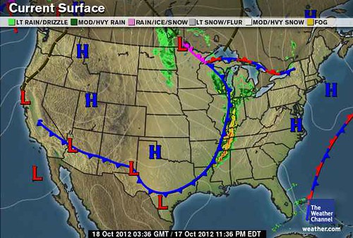
This forecast was posted on Sept 9th and can be found here. The following Weather Channel map is for October 17th and shows a cold front pushing toward the aforementioned area.

Accuweather headlines on the 17th stated "Mississippi Valley Strong Storms Wednesday Night." On the 18th the Weather Channel reported "Midwest Storm Dominates Eastern Weather." By the 18th, this potent cold front moving across the Lower Mississippi Valley acted as the ignition for thunderstorms. The day before, at least 8 people were injured by tornadoes that swept through the Mississippi Valley and the South.
Forecast West Coast U.S.
October 20-21, 2012
Windy and stormy conditions.
Results
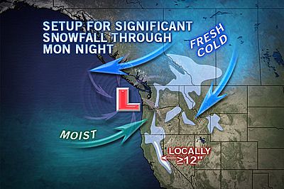
This forecast was for the U.S. West Coast and was posted in August 2012. The following Accuweather map for the 21st shows the low pressure system fulfilling the long-range forecast.

On the 19th, the National Weather Service began to issue urgent winter weather messages for Washington and Oregon calling for the first significant snow of the season to affect mountains and passes. Wind warnings were also posted stating that a strong cold front would bring windy conditions on the 19th and 20th. Sustained winds of 20 to 30 mph with gusts to 45 mph were expected.
Testing Astrometeorology Part 1
Fall Weather 2012: Eastern U.S.
Fall Weather 2012: New England
Fall Weather 2012: Central U.S.
Fall Weather 2012: The U.S. West Coast
Mars Conjunct Saturn August 15, 2012
Jupiter-Neptune and Heavy Rain
The Solar Eclipse of November 13, 2012
Long-range effects of the May 20, 2012 Solar Eclipse
Long-range effects of the May 20, 2012 Solar Eclipse Part 2
Hurricane Season 2011 Forecast Results
Hurricane Risk-Management
New Weather Alternative Website
Overview of UK Winter 2012-13
The Winters of 2011-14
Fulfilled Long-range Forecasts for Hurricane Season 2010
Introduction to the Weather Alternative
Thought of the Day
“Courage is what it takes to stand up and speak, it’s also what it takes to sit down and listen.”—Winston Churchill
No comments:
Post a Comment