The very next day, Tropical Depression Doksuri formed just east of the Philippines affecting the islands on its way toward Hong Kong.
I listed some dates when this crossing would be activated. I expected heavy rain at those times. Here are the results.
August 25, 2012
The Weather Channel reported on August 26th that Typhoon Bolaven was churning in the Philippine Sea with maximum sustained winds of 130 mph.
September 2, 2012
Nothing reported.
October 5, 2012
Tropical Storm Gaemi was located just west of the Philippines destined for Vietnam with heavy rainfall and inland flooding for the Indochina Peninsula.
October 11, 2012
Typhoon Prapiroon developed on the 5th and by the 7th it had entered what is called the Philippine Area of Responsibility, which is essentially the area in and around the Philippines. In this case Prapiroon was in the Pacific Ocean just east of the Philippines.
November 2, 2012
Nothing reported.
November 10, 2012
Tropical Depression 25W moved over the Philippines on November 11th and then entered the South China Sea.
November 24, 2012
Typhoon Bopha formed on the 23rd but very far east of the Philippines. By December 2nd it entered the Philippine Area of Responsibility and was renamed Pablo. It hit the Philippines on December 3rd--too far removed, however, from the forecast date to be counted as a hit.
New England and Eastern Canada
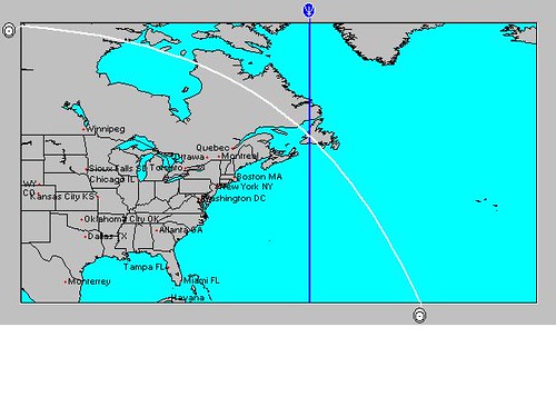
The original forecast also mentioned another crossing related to Jupiter-Neptune. This was over eastern Canada as shown in the map below.

The day after the Jupiter-Neptune square, heavy rain causing localized flooding hit New England and eastern Canada.
August 25, 2012
On the 26th, northern New England received about an inch of rain.
September 2, 2012
On the 3rd, southern Maine received about from 1 to 3 inches of rain. On the 4th, parts of New England saw rainfall of 1 inch or greater.
October 5, 2012
On the 4th, New England registered between 0.25 to 1 inch of rain.
October 11, 2012
Nothing reported.
November 2, 2012
By the 1st, Hurricane Sandy's remnants were leaving the Northeast and New England.
November 10, 2012
On the 12th, a strong cold front swept off the coast with rain and showers.
November 24, 2012
On the 23rd, rain, snow, and windy conditions over New England.
Ireland Weather June 5-10, 2013
California Water Shortage Part 2
April 2013 Heat
California Water Shortage Spring 2013 Forecast
Timing the Relief for Drought-Stricken U.S. Plains
Testing Astrometeorology Part 2
Hurricane Sandy Fulfills Long-range Weather Prediction!
Testing Astrometeorology Part 1
Long-range effects of the May 20, 2012 Solar Eclipse
Long-range effects of the May 20, 2012 Solar Eclipse Part 2
Hurricane Season 2011 Forecast Results
Hurricane Risk-Management
New Weather Alternative Website
Overview of UK Winter 2012-13
The Winters of 2011-14
Fulfilled Long-range Forecasts for Hurricane Season 2010
Introduction to the Weather Alternative
Has Dawkins Lost? Check out the audio link below
Has Dawkins Lost? | Reasonable Faith
No comments:
Post a Comment