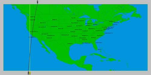
The Uranus-Pluto square of May 20, 2013, placed special influence over the U.S. Pacific Northwest, California, and eastern Pacific. Here's an astro-locality map showing where these two planets left their mark.

The original
square on May 20th brought showers and thunderstorms to the Pacific
Northwest. The storm system stalled and engendered about 5 days of cool and
showery weather. When Mercury squared this degree on June 8, there were windy
conditions over the forecast area. When Venus hit it on June 12, there were
showers and t-storms due to an upper level low. In this post, however, we want to look at triggers from the outer planets, which are more powerful.
Before we do that, another important influence that will be at work over the West Coast states is shown in the key chart for the summer of 2013. A Mercury-Venus conjunction will also fall over this area on June 21st as the summer season begins. The following astro-locality map gives shows the area of influence.

You can see how the line in this map overlaps the line in the first map over northern California. Now, we'll look at some dates when the outer planets trigger the Uranus-Pluto square while other planets are simultaneously activating the Mercury-Venus conjunction in the second map.
July 1-2, 2013
On the 1st, Mercury will retrograde over the Mercury-Venus conjunction while on the 2nd, the Sun will activate the Uranus-Pluto square. Of course, the Sun is not an "outer planet" but it is an important influence in the study of astrometeorology.
The
Sun’s square to Uranus lowers temperatures and excites gusty winds. The Sun’s
opposition to Pluto increases storminess. As Mercury retrogrades over the
Mercury-Venus conjunction, windy conditions and a warm, moist air mass from the
south are indicated. This may play itself out as a clashing of contrary air
masses over the Pacific Northwest and northern California. It may manifest in and around these dates as a Santa Ana wind event or as a strong front that brings stormy conditions or wind.
July 30, 2013
Mars will reach the degree of the Uranus-Pluto square adding a more violent touch to the weather as Mars often does. This means there is the potential for severe thunderstorms or a powerful front that brings whipping winds. A tropical system may develop around this date or pass over 122 west longitude and 23 north latitude, which is about 800 miles west of Cabo San Lucas.
August 15-16, 2013
On the 15th, Mars will conjoin the Mercury-Venus line and on the 16th Jupiter will trigger the Uranus-Pluto square. Jupiter's action will most likely result in more increased wind velocities and lower temperatures. Mars' action, however, besides calling for windy conditions, indicates a southerly air flow. Together, they seem to provide the clash necessary to develop a severe weather pattern in the form of a low pressure system or front in and around these dates. The same area in the eastern Pacific (122 west/23 north) should be monitored for tropical activity.
Tropical Storm Andrea Fulfills Long-range Forecast!
California Water Shortage Part 2
California Water Shortage Spring 2013 Forecast
Timing the Relief for Drought-Stricken U.S. Plains
Testing Astrometeorology Part 2
Hurricane Sandy Fulfills Long-range Weather Prediction!
Testing Astrometeorology Part 1
Long-range effects of the May 20, 2012 Solar Eclipse
Long-range effects of the May 20, 2012 Solar Eclipse Part 2
Hurricane Season 2011 Forecast Results
Hurricane Risk-Management
New Weather Alternative Website
Overview of UK Winter 2012-13
The Winters of 2011-14
Fulfilled Long-range Forecasts for Hurricane Season 2010
Introduction to the Weather Alternative
Connecticut Approves GMO Labeling
No comments:
Post a Comment