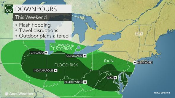
Here's how the forecast, issued 3 weeks in advance, sized up. The forecast was off by a couple of days since today, June 10th, the storms and heavy rain materialized over the Mid-Atlantic region. The original forecast specified the area in and around New York, New Jersey, the Delmarva Peninsula, and New England.
The National Weather Service today issued a Flash Flood Watch for portions of Delaware, northeast Maryland, southern New Jersey, and southeast Pennsylvania.
Periods of rain is expected into Monday morning, some of which will be heavy at times. A total of 1 to 2 inches of rain is expected across much of the watch area. Some thunderstorms may occur through this evening mainly across Delmarva which could lead to locally higher amounts.
In addition to the above Watch, the NWS has issued a Flash Flood Warning for Delaware, Maryland, and a Flood Warning for West Virginia.
Here is an Accuweather map depicting the area to be affected.

Links to Other Long-range Weather Forecasts and Forecast Results
Hurricane Hermine, TD8, and the August 24-28, 2016 Forecast Results
Hurricane Dolores Fulfills Long-range Weather Forecast
Hurricane Season 2015 Long-range Weather Predictions
Tropical Cyclone Hadi
Hurricane Erick Fulfills Long-range Forecast
Tropical Storm Andrea Fulfills Long-range Forecast!
Timing the Relief for Drought-Stricken U.S. Plains
Testing Astrometeorology Part 2
Hurricane Sandy Fulfills Long-range Weather Prediction!
Testing Astrometeorology Part 1
Hurricane Season 2011 Forecast Results
Hurricane Risk-Management
New Weather Alternative Website
Fulfilled Long-range Forecasts for Hurricane Season 2010
Introduction to the Weather Alternative
No comments:
Post a Comment