Monday, October 22, 2012

October 15-21, 2012 Fall Forecast Results

Here are the latest results of long-range weather forecasts for the 2012 fall season. The first forecast was posted back in August of this year for the central U.S. and can be found here.

Forecast
October 15-19, 2012
Venus and Jupiter make adverse aspects to Saturn, and the Sun parallels Saturn. This represents a cold and stormy time for the Plains.

Results

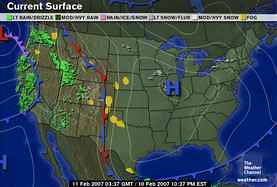
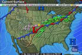
The Weather Channel map below is for Oct 16 and shows a low pressure area affecting the central and northern Plains.
Oct 16
On the 16th, the Weather Channel reported "Wind Maker Rolls into the Plains and Midwest." Their post on the 17th stated "Rain and showers spiral around a large storm system centered in the Great Lakes. It will be wet from the northern and central Plains eastward to the Ohio Valley."

Between the 16th and 17th, this storm system was responsible for wind gusts near hurricane strength over the Plains that spread blustery and chilly conditions to the Ohio Valley. Powerful wind gusts swept into Kansas and Missouri on the 18th, and a powerful storm lingered over Minnesota and Wisconsin.

Forecast
October 17-19, 2012
Mercury will now activate the position of Venus and most likely bring a front or low pressure system that affects 84 west longitude from Michigan down through Florida.

Results
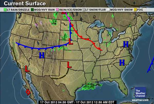
This forecast was posted on Sept 9th and can be found here. The following Weather Channel map is for October 17th and shows a cold front pushing toward the aforementioned area.
Oct 17
Accuweather headlines on the 17th stated "Mississippi Valley Strong Storms Wednesday Night." On the 18th the Weather Channel reported "Midwest Storm Dominates Eastern Weather." By the 18th, this potent cold front moving across the Lower Mississippi Valley acted as the ignition for thunderstorms. The day before, at least 8 people were injured by tornadoes that swept through the Mississippi Valley and the South.

Forecast West Coast U.S.
October 20-21, 2012
Windy and stormy conditions.

Results
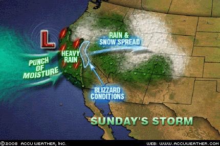
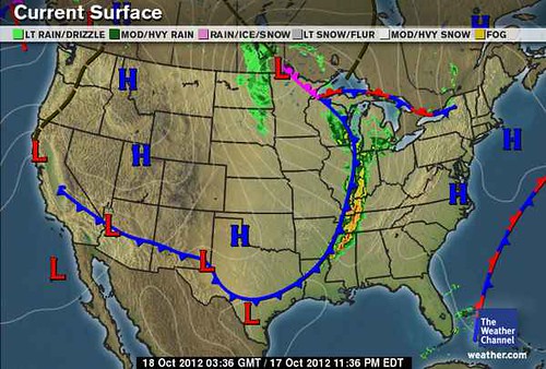
This forecast was for the U.S. West Coast and was posted in August 2012. The following Accuweather map for the 21st shows the low pressure system fulfilling the long-range forecast.
21 West Coast
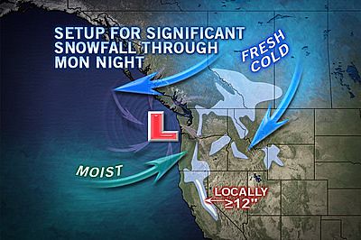
On the 19th, the National Weather Service began to issue urgent winter weather messages for Washington and Oregon calling for the first significant snow of the season to affect mountains and passes. Wind warnings were also posted stating that a strong cold front would bring windy conditions on the 19th and 20th. Sustained winds of 20 to 30 mph with gusts to 45 mph were expected.

Testing Astrometeorology Part 1
Fall Weather 2012: Eastern U.S.
Fall Weather 2012: New England
Fall Weather 2012: Central U.S.
Fall Weather 2012: The U.S. West Coast
Mars Conjunct Saturn August 15, 2012
Jupiter-Neptune and Heavy Rain
The Solar Eclipse of November 13, 2012
Long-range effects of the May 20, 2012 Solar Eclipse
Long-range effects of the May 20, 2012 Solar Eclipse Part 2
Hurricane Season 2011 Forecast Results
Hurricane Risk-Management
New Weather Alternative Website
Overview of UK Winter 2012-13
The Winters of 2011-14
Fulfilled Long-range Forecasts for Hurricane Season 2010
Introduction to the Weather Alternative

Thought of the Day

“Courage is what it takes to stand up and speak, it’s also what it takes to sit down and listen.”—Winston Churchill

Monday, October 15, 2012

Testing Astrometeorology Part 1


Recently, I was reading through astrologer Bruce Scofield’s doctoral dissertation entitled A History and Test of Planetary Weather Forecasting, which he submitted to the University of Massachusetts Amherst in May of 2010. This 249-page dissertation examines the history of astrometeorology, which is a methodology for forecasting weather patterns based on geocentric planetary alignments. As readers of this blog know, that is the subject presented here at The Weather Alternative. Bruce’s dissertation also presents a test of astrometeorology.

Bruce’s hypothesis states that there is a correlation, shown in daily temperature records, between cooling trends in specific regions and the geocentric alignments of the Sun and the planet Saturn. He uses modern daily temperature data from New England, Central England, Prague, and other locations. He finds that his hypothesis is supported by a number of tests that show lower temperatures on days when the Sun-Saturn alignments occur, especially when near the equinoxes. In particular, he studies the opposition aspect between the Sun and Saturn.

The astrometeorological method takes into account a number of factors when determining weather forecasts. First, the time of the aspect in question is noted. By this I mean the day or days when those aspects among the Sun and planets form. Second, the nature of the planets in aspect must be considered. Do the astrometeorological natures of the planets involved in the aspect point toward cold, wind, heat, storms etc.? These natures have been handed down to us by previous weather forecasters of past centuries. Third, certain key charts are used to determine where on earth the influence of the aspect will manifest. Just because a certain aspect might signify cold weather does not mean the whole earth will feel this influence. These key charts localize the influence of the planets in question to certain geographical areas. Now, for whatever reasons, as I understand his test, Bruce deals with the Sun-Saturn oppositions without the localizing effect of these key charts.

I thought I’d give a look at some past Sun-Saturn oppositions with the aid of one of the most important key charts, see where the effects would be localized, and then check the weather for those dates to see if they correspond to the weather experienced. All of the astrometeorological authors, as Bruce points out, agree that Saturn was associated with cold weather. We also find that these same authors associated the Sun-Saturn opposition with stormy periods that delivered rain, snow, hail etc. depending on the season. I’ve used, in each case, the key seasonal chart to localize the influence of the Sun-Saturn opposition. For the winter season, this means the chart for the Sun’s ingress into Capricorn and for the spring season, the Sun’s ingress into Aries. I found a number of seasonal charts that placed the Sun-Saturn opposition over or near the continental United States. I confined my research to these since I have past weather records for the U.S. The first map is for the Sun-Saturn opposition of February 10, 2007. As shown below, the key chart placed the Sun and Saturn off the U.S. West Coast. This would signify an area of great concentration of the cold and storminess promised by the opposition, which would then travel in eastward motion as weather patterns do at those latitudes. Feb 10, 2007
The Weather Channel map for Feb 10, 2007 shows a cold front and stormy conditions (both expected from the opposition) affecting the West Coast states. Feb 10, 2007
On the 10th, the Weather Channel reported: Several storm systems will move into the West bringing rain to the lower elevations and welcome snow the mountains and ski resorts. One of these weather systems will move into Southern California on Sunday (Feb 11) bringing showers to Los Angeles and San Diego with snow above 6000 feet. Snow levels will fall to around 5000 feet in the Sierra Nevada where over a foot of additional snow is forecast by Sunday night. The Wasatch in Utah are forecast to pick up generally as much as 12 inches of new snow above 6000 feet with rain in Salt Lake City.

February 24, 2008


The key chart for the Sun-Saturn opposition of Feb 24, 2008 also placed the Sun and Saturn over the West Coast states as shown in the astro-locality map below. Feb 24, 2008


The following Accuweather map is for Feb 24, 2008. Is shows heavy rain and blizzard conditions affecting California.
24 California Lashing
Accuweather reported the following on the 24th: A powerful storm will continue to blast California with rain, burying mountain snow and howling winds today. A yardstick will be needed to measure the snow that falls in the Sierra through tonight. The storm will bury the ski resorts above 7,000 feet with a total of 3 to 5 feet of snow.

March 8, 2009

The next key chart places the Sun-Saturn opposition of Mar 8, 2009 over the Plains.
Mar 8, 2009

The Weather Channel map below for the 7th, shows a powerful storm system hitting the Plains, which continued for a couple of days.
March 07, 2009
Accuweather headlines on the 7th read: Two Snowstorms Slam Central Plains The first in a pair of snowstorms will blanket the ground with fresh coating of snow from northern Nebraska northeastward into southern Ontario this weekend. The second storm could bring blizzard conditions and heavy snowfall along a similar path, potentially paralyzing travel over some areas and ushering in a wintry blast of cold air.

March 21, 2010
The key chart for the spring season placed the Sun-Saturn opposition over the eastern U.S.
Mar 21, 2010
The following Weather Channel map is for the 22nd and shows a strong storm system over the exact same area.
March 22, 2010
Accuweather reported that locally strong thunderstorms were affecting the Southeast. “The thunderstorms are being triggered by the clash of two distinctly different air masses. Colder air is invading the Southeast, where mild and more moist air currently resides.” They also stated that within a few days biting cold air would take a shot at the Midwest and Northeast.

Conclusion
I think including the locality information provided by the key charts in these examples has served to confirm traditional notions about the effect of Sun-Saturn oppositions. The March 8, 2009 storm was one that I predicted in the preceding February by this astrometeorological method. Click here.

Fall Weather 2012: Eastern U.S.
Fall Weather 2012: New England
Fall Weather 2012: Central U.S.
Fall Weather 2012: The U.S. West Coast
Mars Conjunct Saturn August 15, 2012
Jupiter-Neptune and Heavy Rain
The Solar Eclipse of November 13, 2012
Long-range effects of the May 20, 2012 Solar Eclipse
Long-range effects of the May 20, 2012 Solar Eclipse Part 2
Hurricane Season 2011 Forecast Results
Hurricane Risk-Management
New Weather Alternative Website
Overview of UK Winter 2012-13
The Winters of 2011-14
Fulfilled Long-range Forecasts for Hurricane Season 2010
Introduction to the Weather Alternative

Darwin Dissenter
Thomas Nagel, atheist and philosopher professor at New York University, finds significant weaknesses in neo-Darwinian evolution and chemical evolution. He published his view in a new Oxford University Press book Mind & Cosmos: Why the Materialist Neo-Darwinian Conception of Nature is Almost Certainly False. Click here for some intriguing quotes.

Tuesday, October 09, 2012

October 1-10, 2012 Fall Forecast Results

Here is the next installment of fall forecast results. These long-range weather forecasts were published back in August of 2012 and are based on planetary cycles also known as astrometeorology.

The first forecasts we'll look at were for the Central U.S. and can be found here.

Forecast
October 4-5, 2012
Mercury will parallel Neptune and conjoin Saturn. Around this time the central Plains should experience a southerly air flow first that increases temps and humidity. The weather then may turn cloudy with some possible rain and cooler temps.


Results
On October 4th, Accuweather posted an article about the Blue Norther that was beginning to affect the Central U.S. There definition is as follows:

What is a Blue Norther?

A blue norther is a cold front that brings much cooler air to the Plains and Texas, often with very sudden changes. The wind switches from a southerly direction to a northerly direction when these fronts pass through an area. "You can get a high of 85 degrees, and then a high in the 30s or 40s the next day with rain," AccuWeather Expert Senior Meteorologist Joe Sobel said.

This confirms the long-range forecast which talked about the central Plains experiencing a southerly airflow and increase in temperatures before the weather then turned colder. The next Accuweather map shows the cold temperatures or rather the departure from normal temperatures at this time.
04 Blue Norther

Forecast
October 9-10, 2012

Saturn's trine to Neptune is exact now. Cloudiness, night frosts. Misty or foggy, gloomy or cloudy, showery, lower temps through the Plains area.

Results
The next Accuweather map for the 9th shows the cloudiness mentioned in the long-range forecast.
09 Visible Satellite The following Accuweather map shows the lower temperatures also mentioned in the long-range forecast. 09 Departure from normal

West
The original forecast can be found here.

Forecast

October 1-3, 2012
A cold and possibly windy high pressure area or front affects the region.
Results
On October 2nd, Accuweather reported that the combination of dry air and gusty winds was enhancing the risk for fires across a large part of the West.
On the 3rd, the National Weather Service issued the following warning for the Pacific Northwest:
WINDS...EAST TO NORTHEAST 10 TO 15 MPH WITH GUSTS 20 TO 30 MPH. HOWEVER ON RIDGES AND NEAR THE COLUMBIA RIVER GORGE...EXPECT EAST WIND 20 TO 25 MPH...WITH GUSTS 30 TO 45 MPH.   
Forecast
October 8-10, 2012
A cool, fair weather pattern.
Results
On October 8th, the NWS at Portland, OR posted the following synopsis:
DRY CONDITIONS PERSIST THROUGH THE MIDDLE OF THIS WEEK UNDER THE INFLUENCE OF HIGH PRESSURE OVER THE EAST PACIFIC.
Fall Weather 2012: Eastern U.S.
Fall Weather 2012: New England
Fall Weather 2012: Central U.S.
Fall Weather 2012: The U.S. West Coast
Mars Conjunct Saturn August 15, 2012
Jupiter-Neptune and Heavy Rain
The Solar Eclipse of November 13, 2012
Long-range effects of the May 20, 2012 Solar Eclipse
Long-range effects of the May 20, 2012 Solar Eclipse Part 2
Hurricane Season 2011 Forecast Results
Hurricane Risk-Management
New Weather Alternative Website
Overview of UK Winter 2012-13
The Winters of 2011-14
Fulfilled Long-range Forecasts for Hurricane Season 2010
Introduction to the Weather Alternative

Monday, October 01, 2012

September 25-October 1, 2012 Forecast Results

Here are the results of the first forecasts made at the end of August for the beginning of the fall season.

Central U.S.

Forecast
Sept 30-Oct 1
Mercury will parallel Saturn now and the Moon will opposed Mercury and Saturn on October 1st. Saturn stretches from Texas to Minnesota. We should see increasing cloudiness, easterly winds, lower temps, and possible precipitation.

Results
Mercury's parallel to Saturn as mentioned above is bringing the first major pattern change to the central U.S. As we speak, colder air is starting to funnel down the eastern Rockies into the Plains. Chillier air will move in over the northern and central Rockies to parts of the Plains and Midwest. Check out the Weather Channel map below. 01 Pattern Change Eastern U.S.

Forecast

Sept 25-27

Venus' square to Mars at this time will increase temperatures and bring a front or storm system to the Mid-Atlantic area.

Results

On the 25th, weather forecasters reported, "...the rain and storms may impact the swath from Washington, D.C., to Philadelphia, New York City and Boston during Wednesday (26th). On the 27th, they said, "- A zone of drenching showers and locally gusty thunderstorms from the mid-Atlantic and Ohio Valley to the south-central Plains will once again impact millions of people into Thursday night. Towns and communities from West Virginia to the Delmarva Peninsula will have to be alert late this afternoon and evening for potentially gusty storms...a few of the storms will be capable of producing gusty and potentially damaging winds." The Weather Channel map below is for the 27th and shows a low pressure area over the Mid-Atlantic. Sept 27 West Coast

Forecast

Sept 25-29

A very stormy weather system is expected packing high velocity winds and precipitation over the West Coast.

Results

No major storm system affected the area at this time. On the 27th and 28th a breezy front affected the area with little or no threat of precipitation. The map below shows the front on the 29th. Sept 29

New England

Forecast

Sept 26-27

The Mars-Neptune crossing off the New England coast is triggered now as well as another one further south off the North Carolina coast. This might be an indication of the path of a tropical system that is drawn northward passed the Carolinas toward New England in and around these dates.

Results

Although no tropical system developed, there was heavy rain reported. Sept 27th- Showers associated with a surface low and cold front will move from Pennsylvania and West Virginia into southern New York and southwest New England overnight. Some of the heavier showers could produce rainfall totals in excess of one inch from Pennsylvania to southern New York tonight and Friday. Sept 28th- Pockets of locally heavy rain, especially eastern New England, is possible through tonight, with some spots expected to pick up over an inch.

The following map is for the 26th.

26 East

Fall Weather 2012: Eastern U.S.
Fall Weather 2012: New England
Fall Weather 2012: Central U.S.
Fall Weather 2012: The U.S. West Coast
Mars Conjunct Saturn August 15, 2012
Jupiter-Neptune and Heavy Rain
The Solar Eclipse of November 13, 2012
Long-range effects of the May 20, 2012 Solar Eclipse
Long-range effects of the May 20, 2012 Solar Eclipse Part 2
Hurricane Season 2011 Forecast Results
Hurricane Risk-Management
New Weather Alternative Website
Overview of UK Winter 2012-13
The Winters of 2011-14
Fulfilled Long-range Forecasts for Hurricane Season 2010
Introduction to the Weather Alternative

True Life Values (Click to view)
true_life_values-LRG

Sunday, September 23, 2012

Texas Rain Results

Important Update- Sept 30, 2012:
An interesting comment was made by Accuweather today regarding the recent rain in Texas. They stated, "Even ignoring the recent heavy rain, conditions have been improving as much of Texas is averaging near to above normal in rainfall since late spring." This comment confirms the forecast posted back in November 2011 entitled Texas Summer 2012 (see the link in the next paragraph) in which I mentioned that the Jupiter-Neptune influence would bring above average rainfall.

The August 10, 2012 post entitled More on Texas Rain 2012 gave some dates to look out for regarding rain in Texas. Other posts on the subject are Texas Summer 2012 and Texas Drought Update. These posts explain the role that the Jupiter-Neptune square has in increasing rainfall. The map below shows the position of Neptune and Jupiter through Texas, the Plains, and the Mississippi Valley.


The first date was August 21-25. The map below shows the storms that developed over the Texas area on the 21st.

The National Weather Service explained that an upper level disturbance combined with a warm front and moist air to bring widespread thunderstorms to the Southern Plains. These storms move very slowly and produced heavy rain.

The next forecast was for the period of Sept 1-3. Although no rain developed over Texas, the remnants of Hurricane Isaac hit Arkansas, Missouri, and southern Illinois. When comparing the map below for Sept. 1st and the astro-locality map above, we can see the remnants of Isaac were over the Jupiter line at this time when it was being activated.


Sept 6-8 was forecast to be a period of sultry weather due to increasing temperatures and humidity. On the 5th, the Weather Channel reported severe storms from the Texas Panhandle into Kansas. On the 7th, storms were spreading east in the Appalachians and south into Texas. Hot temperatures were still holding on in South Texas on the 8th. The last forecast period was Sept 16-18. In the map below for Sept 16, we see rain over Texas. Actually, the 16th was the last day of a few days of flooding rain that hit Texas starting late on the 13th. Meanwhile further east, heavy rain was falling from the Gulf Coast to the Great Lakes. In a 24-hour period, 2 to 4 inches of rain fell over Tennessee, Kentucky, and the Appalachians. This is pretty close to the Jupiter line in the astro-locality map. Below is the Accuweather map for Sept 16.

Fall Weather 2012: Eastern U.S.
Fall Weather 2012: New England
Fall Weather 2012: Central U.S.
Fall Weather 2012: The U.S. West Coast
Mars Conjunct Saturn August 15, 2012
Jupiter-Neptune and Heavy Rain
The Solar Eclipse of November 13, 2012
Long-range effects of the May 20, 2012 Solar Eclipse
Long-range effects of the May 20, 2012 Solar Eclipse Part 2
Hurricane Season 2011 Forecast Results
Hurricane Risk-Management
New Weather Alternative Website
Overview of UK Winter 2012-13
The Winters of 2011-14
Fulfilled Long-range Forecasts for Hurricane Season 2010
Introduction to the Weather Alternative

Austrian Economics Predicted the Housing Debacle

Monday, September 17, 2012

Mars Conjunct Saturn Aug 15, 2012 Results

Here are the results of the forecasts for the Mars-Saturn conjunction of August 15, 2012. The forecast was posted on July 15, 2012. It was mentioned how windy, destructive storms and energetic storm systems form at the times of these conjunctions. The first two areas pinpointed were the Plains especially over Texas and Oklahoma as well as of the southern coast of Mexico where tropical storm formation was a possibility.

Forecast
 So around the 15th of August we should see a severe weather pattern develop over the Plains with particular emphasis over the Texas and Oklahoma panhandles where destructive storms, perhaps generating hail, gusty winds, and tornadoes is possible. The crossing off the southern coast of Mexico should be watched around the 15th for the formation of tropical system.

Results
Aug 15
The Weather Channel headline read "Potent Front Slices Eastward Next Few Days"

- Some of these storms will be associated with a strong, southward-moving cold front and could bring the threat for severe weather to portions of Oklahoma and Arkansas.


Aug 16
Severe thunderstorms producing damaging wind gusts and hail are possible from western Tennessee to central Oklahoma through this evening.

The Mars-Saturn line also extended northward into the High Plains. Accuweather reported the following:

The northern Plains will be a battleground between two well defined air masses. The cool shot of air in the wake of the cold front will be driving through warm, moist air moving north across the central Plains. The collision may turn violent for some. Strong storms will rumble across area cities, including Minneapolis, Minn., Sioux Falls, S.D., Madison, Wis., Rapid City, Iowa and Omaha, Neb., among others.

Mexico

The remains of Tropical Depression 7 hit Mexico very near the area mentioned in the long-range forecast but a bit further north. Here's what an internet news reported shared. 17 TD 7

Aug 17 NOLA web site
The National Hurricane Center has issued a special tropical weather outlook to discuss the remnants of Tropical Depression 7, which are located over the southwestern Gulf of Mexico...Locally heavy rains and gusty winds will continue over the area during the next day or two, as the system moves northwestward at about 10 mph.

Forecast
The next portion of the forecast talked about an area of Europe over the North Sea between England and Denmark where a vigorous low pressure system or strong front should develop. The map below shows a strong cold front in between England and Denmark.
16 Europe
Results
Aug 15 - Heavy rain and gales will affect Britain today. Strong gales as well in the Bay of Biscay. Heavy showers are forecast for western and northern parts of France...
Aug 16- Heavy showers are forecast for Denmark with rain across Germany.

Forecast
The third map part of the forecast highlighted the area around 175 east longitude and 27 south latitude or about 725 miles north of New Zealand. This area was to be watched for the formation or passage of a tropical cyclone around the 15th of August.

Results
No tropical cyclones reported.

Fall Weather 2012: Eastern U.S.
Fall Weather 2012: New England
Fall Weather 2012: Central U.S.
Fall Weather 2012: The U.S. West Coast
More On Texas Rain 2012
Mars Conjunct Saturn August 15, 2012
Jupiter-Neptune and Heavy Rain
The Solar Eclipse of November 13, 2012
Long-range effects of the May 20, 2012 Solar Eclipse
Long-range effects of the May 20, 2012 Solar Eclipse Part 2
Hurricane Season 2011 Forecast Results
Hurricane Risk-Management
Texas Summer 2012
New Weather Alternative Website
Overview of UK Winter 2012-13
The Winters of 2011-14
Fulfilled Long-range Forecasts for Hurricane Season 2010
Introduction to the Weather Alternative
Austrian Economics: Why It Matters

Sunday, September 09, 2012

Fall Weather 2012: Eastern U.S.

During the fall season of 2012, Venus will occupy the 84th degree of west longitude. This runs through the states of Michigan, Ohio, Kentucky, Tennessee, Georgia, and Florida. Of course, the influence of this planetary line will extend further east and west of this line of longitude.

  East US

Venus will occupy the sign Leo. This position is said to signify frequent rainfall and thunderstorms. Venus is in a very close square aspect to Mars, which also relates to storminess. Let's look at a few dates when this position will be activated. Of course, other planetary influences will be at work throughout the fall, but these dates and times only pertain to the aforementioned position of Venus.

Forecasts
Sept 25-27
 Venus' square to Mars at this time will increase temperatures and bring a front or storm system to the Mid-Atlantic area.

Oct 17-19
Mercury will now activate the position of Venus and most likely bring a front or low pressure system that affects 84 west longitude from Michigan down through Florida.

Nov 9-11
The transit Sun triggers Venus and Mars which is known to increase temperatures but also carries the potential for storminess throughout the eastern section of the U.S.

Dec 6-7
The last trigger to Venus occurs now and will bring more showers throughout the eastern U.S.

Fall Weather 2012: New England
Fall Weather 2012: Central U.S.
Fall Weather 2012: The U.S. West Coast
More On Texas Rain 2012
Mars Conjunct Saturn August 15, 2012
Jupiter-Neptune and Heavy Rain
The Solar Eclipse of November 13, 2012
Long-range effects of the May 20, 2012 Solar Eclipse
Long-range effects of the May 20, 2012 Solar Eclipse Part 2
Hurricane Season 2011 Forecast Results
Hurricane Risk-Management
Texas Summer 2012
New Weather Alternative Website
Overview of UK Winter 2012-13
The Winters of 2011-14
Fulfilled Long-range Forecasts for Hurricane Season 2010
Introduction to the Weather Alternative

Evolution and Fear of Death

Sunday, September 02, 2012

Fall Weather 2012: New England

Autumn begins on September 22nd this year and ends on December 21st. The astro-localtiy map below shows two planetary influences that will affect the New England area during the season. The line running from north to south represents the planet Neptune, and the diagonal line that crosses it represents the planet Mars. An observer stationed at the point where both the lines cross would observe Mars to be rising at the moment the fall season starts and would would "see" Neptune directly beneath his or her feet.


New England

These planets will affect weather patterns over New England at times during the fall season. I've compiled some dates when both these planets will be activated at the same time. The resulting weather patterns will likely be storm systems known as low pressure areas. Since we are in hurricane season, there is the potential that these low pressure areas or storm centers may be tropical in nature.

Forecasts

September 26-27
The Mars-Neptune crossing off the New England coast is triggered now as well as another one further south off the North Carolina coast. This might be an indication of the path of a tropical system that is drawn northward passed the Carolinas toward New England in and around these dates.

November 10-14
A similar set up forms now as the Mars-Neptune crossing is activated. Neptune also turns stationary on the 11th and then receives a square from Mercury on the 13th. Another crossing develops further to the south off the North Carolina coast at the time of the New Moon. Once again, this could suggest a tropical system that heads northward toward the New England area.

November 21-23
Mercury and the Sun activate the Mars-Neptune crossing. When Mercury and Mars are in aspect, wind is usually a salient feature. Check for a windy front or low pressure system, possibly tropical in nature, over the New England area now.

November 25-27
The weather pattern indicated at this time may be related to the previous one. Mercury will begin its stationary movement now, which is usually a sign of increased wind velocities. Venus will parallel Neptune, which can charge the atmosphere with maximum humidity and bring heavy downpours. All of this is indicated over the New England area now.

December 7-11
Another storm system affects the New England area between these dates.

Fall Weather 2012: Central U.S.
Fall Weather 2012: The U.S. West Coast
More On Texas Rain 2012
Mars Conjunct Saturn August 15, 2012
Jupiter-Neptune and Heavy Rain
The Solar Eclipse of November 13, 2012
Long-range effects of the May 20, 2012 Solar Eclipse
Long-range effects of the May 20, 2012 Solar Eclipse Part 2
Hurricane Season 2011 Forecast Results
Hurricane Risk-Management
Texas Summer 2012
New Weather Alternative Website
Overview of UK Winter 2012-13
The Winters of 2011-14
Fulfilled Long-range Forecasts for Hurricane Season 2010
Introduction to the Weather Alternative

One day the zoo-keeper noticed that the orang-utan was reading two books - the Bible and Darwin's The Origin of Species. In surprise he asked the ape, "Why are you reading both those books"?
"Well," said the orang-utang, "I just wanted to know if I was my brother's keeper or my keeper's brother."

Sunday, August 26, 2012

Olympics Weather Forecast Results

London 2012 Olympic gold medal

On July 21st, I posted some forecasts for the London Olympics. Here are the results.

Forecast
July 27-29: These days seem to indicate a windy weather pattern. There are a number of indications of a warm, southerly air flow indicating warm or hot temps. It's not clear how much precipitation is involved. A low or front may set up off the east coast of England.

Results:
27th: Dry for most, though showers in the east. Feeling cooler.
29th: Sunny spells and showers, some heavy. Breezy and rather cool.
The following map is for the 28th and shows the cold front off the east coast of England as mentioned in the forecast. (All in all not a bad forecast. There was some wind, sun, precipitation, and the front off the coast.)
Europe July 28

Forecast
July 31: Cool, dry weather

Results
31st: A mostly cloudy day. Rain at times this morning but also some drier interludes.

Forecast
August 2: Fair

Results
2nd: Dry for much of the morning with bright or sunny spells. Afternoon showers, mainly dry night.

Forecast
August 3: Increasing moisture brings a chance of rain.

Results
3rd: Dry start with sunny spells but showers will develop, especially from late morning, with some of them likely to be heavy for a time before easing during the afternoon. (Pretty good forecast.)

Forecast
August 4: Southerly winds, rising temperatures.

Results
4th: Some sunny intervals but also showers

Forecast
August 5: Fair conditions.

Results
5th: Further showers are expected, locally heavy at times. (Not good!)

Forecast
August 6-9: Breezy to windy, warm, dry conditions.

Results
6th: Tonight, becoming mainly dry
8th: Dry and warm with sunny spells.
9th: Dry with some warm sunshine inland
10th: Becoming breezy (Good one!)

Forecast
August 10-12: Southerly winds, warm temperatures, moderate humidity.

Results
10th: Continuing sunny and very warm.
11th: Mostly fine on Sunday.
12th: Increasingly cloudy with outbreaks of rain during Monday afternoon. (Not bad except for the last day.)

Fall Weather 2012: Central U.S.
Fall Weather 2012: The U.S. West Coast
More On Texas Rain 2012
Mars Conjunct Saturn August 15, 2012
Jupiter-Neptune and Heavy Rain
The Solar Eclipse of November 13, 2012
Long-range effects of the May 20, 2012 Solar Eclipse
Long-range effects of the May 20, 2012 Solar Eclipse Part 2
Hurricane Season 2011 Forecast Results
Hurricane Risk-Management
Texas Summer 2012
New Weather Alternative Website
Overview of UK Winter 2012-13
The Winters of 2011-14
Fulfilled Long-range Forecasts for Hurricane Season 2010
Introduction to the Weather Alternative

Astrology and Predictions
An excerpt from Astrology News Service's interview with Nina Gryphon. Read the whole interview here.

ANS: You have a law degree. If you were to defend astrological truth claims in a court of law what might your best legal arguments be?

Gryphon: Any lawyer or politician will tell you that to win an argument one must be in control of definitions. The naming of things defines our reality, and thus contains great power. The first task, then, is to define “astrology” in such a way that gives us a chance defending its truth before an imagined objective court. So I would exclude from our definition astrology packaged as entertainment, such as mass media astrology columns. While these predictions may be entertaining, I would not be prepared to defend their accuracy in a court of law.
A working definition of astrology for our case could be: “A means of using celestial bodies to forecast future events.” If we can convince our judge to use our definition, and prove that astrology can perform according to its definition, then we will have won. If astrology can do better at predicting than its mainstream equivalent, this would be an added bonus.
Of course, astrology can be used for much more than just prediction, but predictions are easy to verify. So, our argument would rest upon being able to show that astrology is right a certain percentage of the time in a relatively unambiguous field, such as weather forecasting. Astro-meteorology has an illustrious history, with practitioners as well known as Tycho Brahe and Johannes Kepler. And there are many fine astro-meteorologists carrying on their work today. The added benefit of predicting the weather is that we can compare astrologers’ results with those of mainstream meteorologists. If astrology does better than the meteorologists, which I believe would be the case given the skilled practitioners, astrology would stand alone among the sciences. In either case, a world-view revision would be in order.

Saturday, August 18, 2012

Fall Weather 2012: Central U.S.

Autumn_1

Autumn 2012 will begin on September 22nd and end on December 21st. The long-range forecasts presented here are based on the Cardinal Solar Ingress chart of September 22nd when the Sun enters the astrological sign of Libra. This key chart places the planet Saturn on the Ascendant through the central U.S. Saturn starts out over Texas and the Central Plains states as shown below. Saturn 1

As the season progresses, it will move eastward over the Mississippi Valley until by the end of autumn it will be east of the Mississippi Valley over the East Central States and Deep South as shown below. Saturn 2

Generally, it will affect the weather in the central U.S. Saturn's influence on the weather when under adverse aspects by other planets corresponds to lower temperatures, low pressure (storm systems), east wind, and humidity. Good aspects to Saturn correspond to lower temperatures and fair weather. For most of the fall season, Saturn will be trine Neptune. This aspect has been observed to bring misty, gloomy weather in the lowlands but showery and cooler weather in the interior and higher altitudes.

autumn_fog-full

We'll now look at the dates of some major aspects that Saturn will receive during the season and the type of weather that will most likely ensue.

Forecasts

Sept 30-Oct 1
Mercury will parallel Saturn now and the Moon will opposed Mercury and Saturn on October 1st. Saturn stretches from Texas to Minnesota. We should see increasing cloudiness, easterly winds, lower temps, and possible precipitation.

Oct 4-5
Mercury will parallel Neptune and conjoin Saturn. Around this time the central Plains should experience a southerly air flow first that increases temps and humidity. The weather then may turn cloudy with some possible rain and cooler temps.

images

Oct 9-10
Saturn's trine to Neptune is exact now. Cloudiness, night frosts. Misty or foggy, gloomy or cloudy, showery, lower temps through the Plains area.

Oct 15-19
Venus and Jupiter make adverse aspects to Saturn, and the Sun parallels Saturn. This represents a cold and stormy time for the Plains.

Oct 21-25
Cooler and stormy around the 21st. The Sun's parallel and trine to Neptune around the 23rd should increase southerly air flow and temperatures with perhaps mild or foggy conditions. Then, on the 25th when the Sun conjoins Saturn, things turn stormier most likely due to a cold front. 

Nov 1-2
Saturn now moves closer to the Mississippi Valley and receives an adverse aspect from Mars. This should result in atmospheric disturbance over the eastern Plains and Mississippi Valley. 

Nov 14-16
Saturn and Uranus now in aspect brings fair but cooler weather over the Mississippi Valley. 

Nov 24-26
Mars and Venus aspect Saturn over the Mississippi Valley. Some breezy conditions are shown along with a rise in humidity and temperatures followed by downpours after which things may turn cooler. 

Dec 13-15
The Sun's adverse aspect to Saturn may result in a cold front bringing rain to the Great Lakes area and east of the Mississippi Valley. 

Fall Weather 2012: The U.S. West Coast
More On Texas Rain 2012
Olympics Weather July 27- August 12, 2012
Mars Conjunct Saturn August 15, 2012
Jupiter-Neptune and Heavy Rain
The Solar Eclipse of November 13, 2012
Long-range effects of the May 20, 2012 Solar Eclipse
Long-range effects of the May 20, 2012 Solar Eclipse Part 2
Hurricane Season 2011 Forecast Results
Hurricane Risk-Management
Texas Summer 2012
New Weather Alternative Website
Overview of UK Winter 2012-13
The Winters of 2011-14
Fulfilled Long-range Forecasts for Hurricane Season 2010
Introduction to the Weather Alternative

Today the cornerstone of international law is the sacred, what is sacred in humanity. You should not kill. You should not be responsible for a crime against the sacredness, the sacredness of man as your neighbor… made by God or by God made man…. in that sense, the concept of crime against humanity is a Christian concept and I think there would be no such thing in the loft today without the Christian heritage, the Abrahamic heritage, the biblical heritage. -- Jacques Derrida

Thursday, August 16, 2012

July 20-29, 2012, Forecast Results

The Weather Alternative post of June 3, 2012 contained long-range weather forecasts for the period of July 20-29, 2012. Let's look at how these forecasts turned out.


Forecast

The first forecast concentrated on the period between July 20-23. The forecast stated that the areas of the U.S. that had experienced severe weather during November 26-27, 2011 would now experience another round of severe weather since the same astrological set-up was being triggered again. Back in November the Upper Midwest and mid-Mississippi Valley were slammed by rain and snow, which then progressed on to douse eastern Tennessee and the Appalachians.

I thought we could expect an increase in moisture and temperatures over the Plains leading to storms bringing heavy rain. These would then continue eastward over the Mississippi Valley and Appalachians.

Results

By the 20th and 21st, weather forecasters were reporting on the sizzling heat that was gripping the Plains. Heat that drove temperatures 5 to 15 degrees above normal. A frontal boundary draped itself across the Tennessee Valley. The same area of the Upper Midwest that took a hit back in November was now under the gun again. On the 21st, the area from South Dakota to Wisconsin received 1 inch downpours. Once again, as in November, the mid-Mississippi Valley was hit with flash flooding due to drenching thunderstorms. Further south in the lower Mississippi Valley, Jackson, MS, picked up 2.55 inches of rain, more than half of what they get in a normal July. Severe downpours continued in the northern Plains on the 23rd.

Forecast

The next section of the forecast dealt with the period around July 26-27. A previous astrological set-up was also being triggered in this case. Severe weather was to be expected in the form of above-average rainfall over the Mississippi Valley and eastern U.S. similar to, but not as intense, as the heavy rains that hit the Mississippi Valley back in April and May of 2011.
26 Severe

Results

This first map for the 26th, shows the area of the central and eastern U.S. that were experiencing severe thunderstorms. The storms impacted millions and snarled air travel across the area. 27 Severe Storms

This next map is for the 27th and shows the lower Mississippi Valley and eastern U.S. under the threat of storms that could produce small hail, strong winds, and torrential rain. My forecast also called for windy conditions over the Rockies, but none were reported.

Forecast

The last section of the forecast predicted tropical activity over the Lesser Antilles and in and around San Salvador in Central America.

Results

On July 28th, Accuweather reported that the tropics were once again coming to life after about a month of dormancy. A tropical wave was approaching the Lesser Antilles and arrived there on the 30th. It did not develop further. Not much developed over Central America except for moderate to strong convection over Panama and Costa Rica.

Fall Weather 2012: The U.S. West Coast
More On Texas Rain 2012
Olympics Weather July 27- August 12, 2012
Mars Conjunct Saturn August 15, 2012
Jupiter-Neptune and Heavy Rain
The Solar Eclipse of November 13, 2012
Long-range effects of the May 20, 2012 Solar Eclipse
Long-range effects of the May 20, 2012 Solar Eclipse Part 2
Hurricane Season 2011 Forecast Results
Hurricane Risk-Management
Texas Summer 2012
New Weather Alternative Website
Overview of UK Winter 2012-13
The Winters of 2011-14
Fulfilled Long-range Forecasts for Hurricane Season 2010
Introduction to the Weather Alternative

Atheists themselves used to be very comfortable in maintaining that the universe is eternal and uncaused. The problem is that they can no longer hold that position because of modern evidence that the universe started with the Big Bang. So they can't legitimately object when I make the same claim about God-he is eternal and he is uncaused. --William Lane Craig

Wednesday, August 15, 2012

Fall Weather 2012: The U.S. West Coast

Fall

This year the fall season will begin on September 22, 2012 when the Sun crosses the equator on its southward journey. An astro-locality map set for this time, shows a number of planets that are positioned over the Pacific Northwest and northern California and that will affect weather patterns over this area. The presence of Uranus and Pluto in a tight square along with Mercury promises a boisterous, stormy season when these planets are activated throughout the ensuing months. Following are some of the dates and brief descriptions of the weather to excpect at those times.

Sept 25-29, 2012
very stormy weather system is expected packing high velocity winds and precipitation over the West Coast.

October 1-3, 2012
A cold and possibly windy high pressure area or front affects the region.

October 8-10, 2012
A cool, fair weather pattern.

October 20-21, 2012
Windy and stormy conditions.

November 1-3, 2012
A front or storm systems enters the area.

November 4-6, 2012
Southerly winds bring increasing temperatures.

November 14-15, 2012
Colliding air masses produce stormy conditions along the coast.

November 20-23, 2012
A windy and stormy system hits the area.

November 26-27, 2012
Cold, high pressure may collide with a warm, moist air mass and generate stormy conditions along the coast.

November 28-30, 2012
Stormy conditions continue along the coast as winds push inland.

December 13-17, 2012
Cold, high pressure and wind over the region.

More On Texas Rain 2012
Olympics Weather July 27- August 12, 2012
Mars Conjunct Saturn August 15, 2012
Jupiter-Neptune and Heavy Rain
The Solar Eclipse of November 13, 2012
Long-range effects of the May 20, 2012 Solar Eclipse
Long-range effects of the May 20, 2012 Solar Eclipse Part 2
July 20-29, 2012 Long-range Weather Forecast
Hurricane Season 2011 Forecast Results
Hurricane Risk-Management
Texas Summer 2012
New Weather Alternative Website
Overview of UK Winter 2012-13
The Winters of 2011-14
Fulfilled Long-range Forecasts for Hurricane Season 2010
Introduction to the Weather Alternative

“Every generation imagines itself to be more intelligent than the one that went before it, and wiser than the one that comes after it.”—George Orwell

Friday, August 10, 2012

More On Texas Rain 2012

I've dedicated a number of posts over the last months to the need for rain in Texas. The key planetary influences during the spring and summer of 2012 have been Neptune and Jupiter. My first post back in November 2011, Texas Summer 2012, explained the role of Neptune and the Neptune-Jupiter square. Then in June of this year, I discussed how those predictions were being fulfilled in a post entitled Texas Drought Update. In July of this year, I posted the dates and places that will be affected by the Jupiter-Neptune square in a post called Jupiter-Neptune and Heavy Rain.


In this post we'll look at some dates when the Jupiter-Neptune configuration over Texas will be activated in August and September of this year. We'll discuss the likelihood of these aspects producing needed rain. Here is a look at the astro-locality map for the summer season with the positions of Neptune and Jupiter. Ne Ju
 Neptune's position is shown by the yellow line running along the 101st degree of west longitude, and Jupiter's position is shown by the black line running along the southern coast of Texas, across the Mississippi Valley and into the Great Lakes. These positions were activated recently by the Last Quarter Moon of July 10, 2012. The weather that ensued brought some good rain to southern Texas. The next map is a precipitation map for July 11, 2012. It shows the rain basically forming the same pattern the planetary lines do in the astro-locality map.
  11 Ne-Ju lines

Forecasts
August 21-25, 2012
Around this time a number of important aspects are made to Neptune which include the parallel of Mars. This parallel aspect, exact on the 21st, increases temperatures and humidity, so we may be looking at a heat wave but with the potential to trigger thunderstorms. The Sun makes a contra-parallel to Neptune on the 22nd, which also increases temps and humidity. The big action happens on the 24th when the First Quarter Moon falls in square and opposition along with Venus' ses-square to Neptune. These aspect seems to have more power to increase, not only temps and humidity, but rain potential.

Sept 1-3, 2012
At this time, Mercury will oppose Neptune. This aspect also increases temperatures by inducing southerly air flows and increasing temperatures and humidity with the chance of precipitation.

Sept 6-8, 2012
Venus now will make a minor aspect to Neptune. At the most this should once again should bring sultry weather due to increasing temperatures and humidity.

Sept 16-18, 2012
Mercury aspects Neptune bringing southerly winds and higher temperatures.

Olympics Weather July 27- August 12, 2012
Mars Conjunct Saturn August 15, 2012
Jupiter-Neptune and Heavy Rain
The Solar Eclipse of November 13, 2012
Long-range effects of the May 20, 2012 Solar Eclipse
Long-range effects of the May 20, 2012 Solar Eclipse Part 2
July 20-29, 2012 Long-range Weather Forecast
Hurricane Season 2011 Forecast Results
Hurricane Risk-Management
Texas Summer 2012
New Weather Alternative Website
Overview of UK Winter 2012-13
The Winters of 2011-14
Fulfilled Long-range Forecasts for Hurricane Season 2010
Introduction to the Weather Alternative

Culture War Erupts Over Chick-fil-A