Saturday, January 28, 2006

Forecast Results


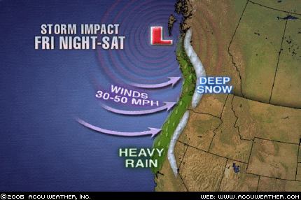
On January 18th, I posted forecasts for potent storms to afflict the Northwest and Northeast U.S. between January 26-28, 2006. (Click here for forecast)

Here are the results:

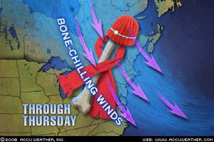
Graphic courtesy of Accuweather

The Weather Channel reported that on January 25th "Strong winds behind a departing low will continue to affect the Northeast with gusty winds as high as 40 mph through Thursday (Jan 26) in some locales. Lake-effect snow will be falling across Northeast Ohio, Northwest Pennsylvania and Western and Northern New York state where some locations will see as much as 6-12" of snow into Thursday."


Graphic courtesy of Accuweather

The Weather Channel reports today that "A moisture-ladened Pacific storm is crashing ashore this morning along the coastal areas of the Pacific Northwest. The storm is packing plenty of wind, heavy rain and snow. Winds along coastal Oregon gusted late last night and this morning between 60 and 90 mph. Cape Blanco, Ore. has consistently gusted over 80 mph this morning. Precipitation should slide down into California and a winter storm warning is in effect for the Lake Tahoe area where at lake level 3 to 6 inches of snow is expected combined with winds gusting to 50 mph. Winds could gust to 120 mph over the ridge tops of the Sierra and 80 mph through the foothills of western Nevada."

Wednesday, January 18, 2006

January 26-28, 2006 Storm Alert

Two potent storm systems will afflict the East and West Coasts of the United States between January 26-28, 2006. Several weather cycles now culminate resulting in predominant low barometric pressure and above normal precipitation.

These storms should center over the Pacific Northwest, and the Northeast into New England.

Friday, December 09, 2005

Hurricane Season 2006


Work is under way on long-range weather forecasts for Hurricane Season 2006. This will take awhile before they are posted.

Another project to be posted is the forecast results of The Weather Alternative forecasts for October and November 2005.

Monday, November 28, 2005

Great Plains Blizzard of 2005


Click here for November Forecasts.

Graphics courtesy of Accuweather.com

Conventional forecasters are saying that the blizzard affecting the Northern Plains with over a foot of snow and sustained winds of 40 mph and gusts up to 60 mph will go down is history as the Great Plains Blizzard of 2005.

The Weather Alternative posted the following forecast on September 9, 2005:

November 27-29, 2005:

Forecast: Increasing wind speeds and falling temperatures will be the story from the western Great Lakes, across the Mississippi Valley, and eastward as cold Canadian air pushes southward. This weather pattern will extend across the eastern Great Lakes and into the Mid-Atlantic area etc...

Saturday, November 26, 2005

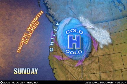
Cold and Windy West


Click here for November Forecasts

Weather Graphic courtesy of Accuweather.

This Weather Alternative forecast was posted on September 9th, over 2 months ago.

November 27-29, 2005:

Forecast: A cool high pressure area will enter the West Coast. This drier air mass may ignite some storms and windy conditions in its attempt to establish itself over the region.

The Weather Channel reports that "strong, gusty winds are expected to gallop over the Southwest—especially the higher elevations—and the southern Great Basin. Strong Santa Ana winds are likely tonight and early tomorrow in Southern California."

The National Weather Service has issued a frost adivsory for parts of California:

NATIONAL WEATHER SERVICE

HANFORD CA

636 PM PST SAT NOV 26 2005


...FROST ADVISORY ISSUED FOR THE CENTRAL AND SOUTHERN
SAN JOAQUIN VALLEY FOR TONIGHT....A COLD AND DRY AIRMASS...ALONG WITH LIGHT WINDS AND CLEARSKIES...OVER THE CENTRAL AND SOUTHERN SAN JOAQUIN VALLEY WILL ALLOW TEMPERATURES TO DROP TO NEAR FREEZING BY EARLY
SUNDAY MORNING.

Tuesday, November 22, 2005

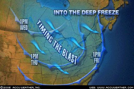
Midwest Blast


Click here for November Forecasts.

Graphics courtesy of Accuweather.com

Here's another Weather Alternative forecast that was posted back on September 9, 2005:

November 21-24, 2005:
Forecast: This promises to be a very active period for the Plains. The necessary ingredients to produce blizzard-like conditions seem to be present over the Northern Tier States.

The National Weather Service has issued Winter Storm warnings for the Great Lakes area.

URGENT - WINTER WEATHER MESSAGE

NATIONAL WEATHER SERVICE

MARQUETTE MI 519 PM EST TUE NOV 22 2005


...DANGEROUS WINTER STORM FOR THE THANKSGIVING HOLIDAY...

.LOW PRESSURE MOVING INTO THE UPPER GREAT LAKES WEDNESDAY WILL INTENSIFY AS IT MOVES SOUTHEAST INTO THE CENTRAL GREAT LAKES WEDNESDAY NIGHT. BEHIND THE LOW PRESSURE...A BLAST OF ARCTIC AIR WILL SURGE ACROSS LAKE SUPERIOR...GENERATING HEAVY LAKE EFFECT SNOWSHOWERS ACROSS UPPER MICHIGAN WEDNESDAY NIGHT THROUGH THURSDAYNIGHT. VERY STRONG NORTHERLY WINDS WILL CREATE BLIZZARD CONDITIONS NEAR LAKE SUPERIOR WEDNESDAY NIGHT THROUGH THE THANKSGIVINGHOLIDAY.

Saturday, November 19, 2005

Approaching East Coast Storm


Click here for November Forecasts

Graphics courtesy of Accuweather.com

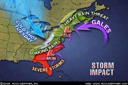
As shown above, conventional forecasters are predicting a major East Coast storm Monday and Tuesday, November 21-22, 2005.

Accuweather states "Adverse weather with the big East Coast storm will begin in the Southeast late Sunday and early Monday before spreading quickly through the Eastern Seaboard to New York and New England Monday through early Tuesday... Much of Florida and Georgia through the coastal plain of the Carolinas and southeastern Virginia will have a threat of severe local thunderstorms, including hail, high winds and even isolated tornadoes... Another factor will be that of high winds, especially coastal winds, as the storm spins up dramatically late Monday through Tuesday. New England will bear the brunt of coastal winds along with tide and wave action, but there will be strong winds well inland at this time too. As if these were not enough, there will be a wintry side to the storm, too. Cold air will pour into the Midwest Monday night and Tuesday.

(Bold print added by The Weather Alternative)

On September 9th of this year, The Weather Alternative posted forecasts for November 2005. The East Coast storm and the cold air entering the Midwest were mentioned in these forecasts although the timing seems to be a day or so off.

For example, the cold air to pour into the Midwest on the 21st and 22nd was mentioned in the November 19-20 forecast:

"Another bout of blustery weather and lower temperatures is shown for the Mississippi Valley and Eastern U.S. "

The East Coast storm scheduled for Monday and Tuesday November 21-22 was specified in The Weather Alternative forecast for November 23-24:

"The clash between high and low pressure systems will focus on the coastal areas of Virginia and North Carolina. High winds or severe storms are likely to hit this area. This may be part of a larger weather pattern that affects the Mid-Atlantic area."

Monday, November 14, 2005

Tropical Storm Gamma and Midwest Storm


Click here for November Forecasts.

Here are some updates on The Weather Alternative's November Forecasts. These were prepared between August 21, 2005 and September 6, 2005.

November 12-15, 2005:
Forecast: It seems that a tropical weather system, be it a tropical wave, storm etc., or other severe weather pattern will affect HispaƱola.

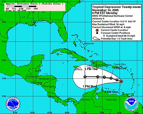
As can be seen from the above map, Tropical Depression 27 (soon to be upgraded to Tropical Storm Gamma) is forecast to pass close to HispaƱola over the next few days.

Another Weather Alternative forecast that's shaping up is the following:

November 14-17, 2005:
Forecast: The incursion of colder air over the eastern half of the country and consequent tumbling temperatures will necessitate frost and freeze advisories over the region. The 16th and 17th appear to be high points when cold air and windy conditions will manifest over the Mississippi Valley area.

The Weather Channel reports the following:

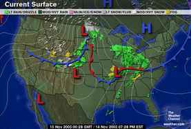
A strong cold front will smash into the South tomorrow, and with it, some very dangerous weather. While scattered showers and storms will speckle much of the South, nasty thunderstorms with the potential for damaging winds and violent tornadoes will sweep eastward from the eastern parts of Oklahoma and Texas across the Mississippi Valley during the daylight hours and on eastward during the evening. At highest risk for potentially deadly storms are eastern Arkansas, western Tennessee, northern Mississippi and northwest Alabama. Behind the front, gusty winds will hurl colder air southward toward the Texas Gulf Coast and eastward into the lower Mississippi Valley.

Saturday, November 05, 2005

West Coast and Midwest Storms


Click here for November Forecasts

The Weather Alternative forecasts for November 2005 were prepared between August 21, 2005 and September 6, 2005.

Here's an update on two forecasts for November 5-7, 2005.


Forecast: Another round of storms batters the West Coast States. Moist, warm air finds its way over the region producing "caffeinated" storms over the Intermountain West.

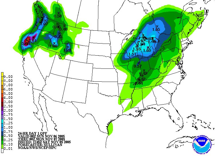
Today the Weather Channel reported "Another Pacific storm will take aim on the Pacific Northwest today resulting in increasing winds, rain and snow. This system is the latest, in a series of storms, to batter the Pacific Northwest and this trend will continue next week. A flood watch in effect for today and through much of Sunday for northwestern Oregon including the Willamette Valley."


Forecast: As warm, moist air is funneled northward over the Plains, colder, drier air rushes southward over the Mississippi Valley. The inevitable result is that storms will erupt over both these areas as the colder air collides with this southerly invasion. Watch, in particular, for strong storms over the Arrowhead of Minnesota. Gusty winds usually accompany this pattern.

Today Accuweather related the following: "Cold air blasting in from the northern Plains is colliding with warm, moist air from the South, creating an explosive, fast-moving band of thunderstorms that will pummel the Midwest and parts of the Great Lakes today. The region will experience a line of strong storms with high winds, locally heavy rainfall, and possibility of hail. Scattered power outages are possible due to the high winds and damage caused by the storms."

Friday, October 28, 2005

Coastal Storm


Click here for October Forecasts

Click here for November Forecasts

The Weather Alternative forecast for October 28-30, 2005 was as follows:

As cold air pushes through the Northeast US, storm conditions will develop over Maryland, Delaware, and surrounding States.

Today The Weather Channel reported:
(Bold print added by The Weather Alternative)

While the weekend starts off frosty in the Mid-Atlantic, a showery and cold upper-level low and a developing coastal storm, heading northeastward from east of the Outer Banks, will bring some rain and wet snow to parts of New England overnight and Saturday.

Saturday, October 22, 2005

Tropical Depression 25/Tropical Storm Alpha


Click here for October Forecasts

Click here for November Forecasts


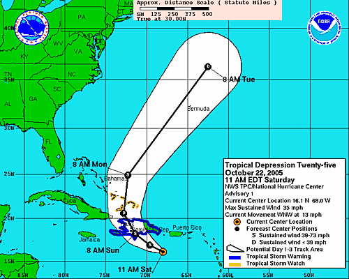
The Weather Alternative forecast for October 25-26, 2005, posted on October 3, 2005, warned that "The inhabitants the Dominican Republic should prepare for possible tropical storm or hurricane passage as the area just south of there (69W/17N) has the potential to attract a low pressure system."

The National Weather Service expects TD 25 to become Tropical Storm Alpha later today.

Their Tropical Depression Twenty-five Advisory Number 1 forecasts the following for Hispaniola (Dominican Republic and Haiti):

THE DEPRESSION IS EXPECTED TO PRODUCE TOTAL RAIN ACCUMULATIONS OF 4TO 8 INCHES OVER MUCH OF HISPANIOLA...WITH POSSIBLE ISOLATED MAXIMUM AMOUNTS OF 12 INCHES. THESE RAINS COULD PRODUCE LIFE-THREATENING FLASH FLOODS AND MUD SLIDES.

Tuesday, October 18, 2005

Where is Wilma headed?

Click here for October Forecasts

Click here for November Forecasts


Hurricane Wilma

In a recent post entitled Some October Forecasts, I mentioned "Tropical storm formation seems likely north of Haiti near 72 West Longitude and 22 North Latitude. The island itself should feel the effects of tropical downpours at this time."

MSNBC reported today that "Hurricane Wilma triggered mudslides that killed up to 10 people in Haiti as the season’s record-tying 21st storm strengthened rapidly on Tuesday and headed for the Gulf of Mexico on a path toward storm-weary Florida."

Conventional forecasters foresee Wilma hitting southern or central Florida by this weekend. This Saturday, the 22nd, shows important planetary alignements between the Sun and Jupiter, and Mercury and Mars. The recent Lunar Eclipse of October 17th focuses some of these energies over the Florida Panhandle. This may be an indication where Wilma will make landfall.

Monday, October 03, 2005

Some October Forecasts

Click here for long-range forecasts for November 2005.


October 13-15, 2005
A strong cold front will push across the eastern US lowering temperatures and exciting gusty winds. There is a possibility that the front will interact with a tropical system in the eastern Gulf of Mexico around 84 West Longitude and 25 North Latitude threatening the Florida Panhandle and eastern Gulf States.
The Mississippi Valley will see stormy conditions while the West Coast gets a shot of colder air and windy weather that moves into the Great Basin.


October 14-15, 2005
A developing storm will take aim on the New England area as moisture is drawn up from the south and interacts with colder Canadian air.
Tropical moisture heads toward the Yucatan of Mexico resulting in heavy rain.


October 15-18, 2005
Tropical storm
formation or passage is indicated in the northwestern Gulf of Mexico around 94 West Longitude and 26 North Latitude. Long-range forecast models show that the coastal areas of eastern Texas and western Louisiana will most likely feel the effects of this tropical influence.
Extreme southern Mexico, around the State of Oaxaca should experience heavy rains due to an influx of tropical moisture.
Tropical storm formation seems likely north of Haiti near 72 West Longitude and 22 North Latitude. The island itself should feel the effects of tropical downpours at this time.


October 20-21, 2005
Relative humidities will increase over the Mississippi Valley and eastward. This may result in fog potential or lower barometer resulting in precipitation.
The potential for tropical downpours is indicated over the southern Mexican State of Chiapas.


October 22-23, 2005
What appears to be a powerful storm system will leave its mark over the Four Corners region of the Rockies and Nevada as it brings gusty winds and rain to the region.


October 25-26, 2005
The inhabitants the Dominican Republic should prepare for possible tropical storm or hurricane passage as the area just south of there (69W/17N) has the potential to attract a low pressure system.
In the eastern Pacific, the area in and around 120 West Longitude and 15 North Latitude (about 850 miles southwest of Cabo San Lucas) is another potential area for hurricane or tropical storm genesis.


October 28-30, 2005
As cold air pushes through the Northeast US, storm conditions will develop over Maryland, Delaware, and surrounding States.

Friday, September 30, 2005

Hurricane Otis

Click here for November 2005 long-range weather forecasts.


Hurricane Otis

Following is a forecast published in the September 2005 issue of El Quinto Sol, a Mexican magazine.


October 1-3, 2005:
Increasing temperatures disrupt atmospheric conditions. The target area is Northwest Mexico and the Gulf of California where there may even be some tropical activity or at least noticeable storms.

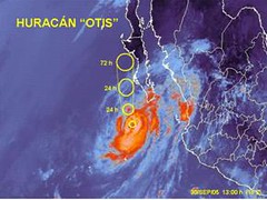
This is now being fulfilled in Hurricane Otis, which, according to the National Weather Service "is expected to steer WNW around a deep layered ridge eventually turning north and crossing the Central Baja Peninsula."

Monday, September 26, 2005

The Weather Alternative

From alternative music and media to alternative medicine, we're increasingly offered nontraditional replacements to mainstream methods, institutions and practices. Although conventional approaches serve a purpose, growing awareness of their limitations and flaws impel men to explore along the fringe for new, and in some cases, ancient solutions.

So why not alternative weather forecasts? Present day orthodox forecast techniques lack the ability to accurately predict the weather beyond three or four days. Even with the assistance of the largest weather computer in the world, whose lightning-fast calculations approach about 400 million per second, the results of its three-day forecasts are speculative; its six to seven day forecasts are worthless. According to conventional weather forecasters, this is due to the complexity of atmospheric forces and processes.

For example, on September 19, 2002 Tropical Storm Isidore roamed off the southwestern coast of Cuba. Forecasters were pretty confident its trajectory would take it over the island and then out into the waters of the south-central Gulf of Mexico. After that, it was anybody’s guess. One forecaster commented after noticing that computer models showed so much disagreement that it was time to dust off the chaos butterflies of MIT Professor Ed Lorenz. He was referring to the discovery Lorenz made while working with computer-simulated weather. Lorenz found that even a very slight alteration of the original variables used in his computations produced drastically different “weather” results. This small change in input resulting in a huge change in output was termed the “butterfly effect” since something as small as the wind produced by a butterfly’s flapping wings could theoretically contribute to the production of a hurricane somewhere in the world.

What some scientists see as complexity, however, might actually be viewed as simplicity when the frame of reference is changed. Johannes Kepler, the 17th century astronomer and discoverer of the planetary laws of motion, experimented with what today would be considered an alternative forecast method that made long-range weather forecasts possible. Kepler observed that the angular relationships among the planets coincided with the formation of weather systems here on Earth that, in turn, produced storms, droughts, floods, etc. His first brush with fame came not because of his breakthrough regarding the planetary laws of motion but because of his accurate long-range weather forecast of the severe winter that put Styermark, Germany on ice in 1593. Since the planets move in repetitive cycles that can be known beforehand, he reasoned, the weather induced by them can also be known beforehand.

We can all see the advantages that such predictions could have. Accurate long-range weather forecasts would bring enormous benefits to the weather derivatives market, agriculture, transportation, construction, and other industries, not to mention the lives that could be saved through advance knowledge of severe weather conditions.

The Weather Alternative's forecast system is based on Kepler's work. Although no forecast method, be it conventional or alternative, can claim 100 percent accuracy, it is interesting to note the dependability this method offers.

Saturday, September 24, 2005

More on Rita's Path


Hurricane Rita

On September 21st, I posted the following:

The Weather Alternative's forecasts are based on planetary cycles. One forecast model shows the potential for increased wind velocities and storm conditions around September 24, 2005 at 88 West Longitude and 30 North Latitude. This is roughly the area around Mobile, Alabama. With Rita now churning in the Gulf of Mexico, this may be an indication of where she makes landfall. Orthodox forecasters, at present, are showing possible landfall further west along the Texas Gulf Coast.

The aforementioned forecast model did not show Hurricane Rita's point of landfall, but it certainly did bring increased wind velocities and storm conditions around the Moblie, Alabama area on the 24th. Here's what the National Weather Service had to say:

URGENT - WEATHER MESSAGE
NATIONAL WEATHER SERVICE
MOBILE AL
1110 AM CDT SAT SEP 24 2005

...WIND ADVISORY REMAINS IN EFFECT THROUGH 400 PM TODAY...

...THE NATIONAL WEATHER SERVICE IN MOBILE HAS ISSUED A FLASH FLOODWATCH THROUGH SUNDAY...

SPIRAL BANDS OF HEAVY RAIN WILL PERIODICALLY MOVE ACROSS THE AREA TODAY...AND...TONIGHT AND SUNDAY AS RITA SLOWS AND BEGINS TO MOVE A LITTLE MORE TOWARD THE EAST OVER INTERIOR PORTIONS OF LOUISIANA AND SOUTHERN ARKANSAS...

RAIN ACCUMULATIONS WILL GENERALLY BE 1 TO 2 INCHES...WITH ACCUMULATIONS OF 2 TO 4 INCHES POSSIBLE TONIGHT THROUGH SUNDAY.

Wednesday, September 21, 2005

Rita's Path?

The Weather Alternative's forecasts are based on planetary cycles. One forecast model shows the potential for increased wind velocities and storm conditions around September 24, 2005 at 88 West Longitude and 30 North Latitude. This is roughly the area around Mobile, Alabama. With Rita now churning in the Gulf of Mexico, this may be an indication of where she makes landfall. Orthodox forecasters, at present, are showing possible landfall further west along the Texas Gulf Coast.

Friday, September 09, 2005

Long-Range Weather Forecasts November 2005

These forecasts were compiled between August 21, 2005 and September 6, 2005.


Atlantic

November 5-7, 2005:

Forecast: Tropical storm and/or hurricane development or passage is imminent around 72 West Longitude and 22 North Latitude. This is roughly 160 miles north of Haiti and somewhat southwest of the Bahamas. It may be a broad weather pattern that affects Hispanola and/or south of it.


November 5-6, 2005:

Forecast: The potential for tropical storm formation is indicated around 50 West Longitude and 8 North Latitude.


November 20-21, 2005:

Forecast: Tropical activity possible in and around 50 West Longitude and 8 North Latitude.


November 22-24, 2005:

Forecast: Tropical storm or hurricane formation is likely along 63 West Longitude and 20 North Latitude. This lies about 265 miles northeast of Puerto Rico.


Caribbean

November 1-2, 2005:

Forecast: Watch for heavy rains or a tropical system over area comprising Jamaica and eastern Cuba.


November 12-15, 2005:

Forecast: It seems that a tropical weather system, be it a tropical wave, storm etc., or other severe weather pattern will affect HispaƱola.


November 23-24, 2005:

Forecast:
Tropical storm or heavy rains for the area around Jamaica and eastern Cuba.


U.S. Mainland

November 2-4, 2005:

Forecast: A cold Canadian air mass will sink southward over the northern Plains States with the potenial for triggering storms over the Dakotas, Minnesota, Nebraska, and Iowa.


November 2-4, 2005:

Forecast: A chilly air mass from northern regions will descend over the Northeast U.S. and generate wet and soggy conditions as it interacts with a moisture already in place.


November 3-5, 2005:

Forecast: A strong cold front will push into the West Coast area bringing rain and colder temperatures as it progresses through the Intermountain West.
The Rockies will eventually feel the brunt of this system especially over Utah and Colorado.

November 5-7, 2005:

Forecast: Another round of storms batters the West Coast States. Moist, warm air finds its way over the region producing "caffeinated" storms over the Intermountain West.

Forecast: As warm, moist air is funneled northward over the Plains, colder, drier air rushes southward over the Mississippi Valley. The inevitable result is that storms will erupt over both these areas as the colder air collides with this southerly invasion. Watch, in particular, for strong storms over the Arrowhead of Minnesota. Gusty winds usually accompany this pattern.


Forecast: Cold and windy conditions, originating in the central U.S., rush eastward toward the eastern Great Lakes, Mid-Atlantic, and Southeast.


Forecast: New England may be dealing with a weather phenomenon all its own. One forecast model indicates a storm system south of Maine, roughly at the latitude of Washington DC, that heads northward toward New England. This may represent a Nor’easter or a tropical system.

November 11-13, 2005:

Forecast: Cool and fair conditions are shown for the eastern portion of the country most likely courtesy of a high pressure system over Canada or the Great Lakes area.

November 13-15, 2005:

Forecast: Rising temperatures over the Intermountain West may erupt in thunderstorms.


November 14-17, 2005:

Forecast: The incursion of colder air over the eastern half of the country and consequent tumbling temperatures will necessitate frost and feeze advisories over the region. The 16th and 17th appear to be high points when cold air and windy conditions will manifest over the Mississippi Valley area.


November 15-17, 2005:

Forecast: An active weather pattern is promised for the Rockies as moisture is drawn up from the Gulf of California sparking severe thunderstorms over Arizona, Utah, and surrounding areas.


November 17-18, 2005:

Forecast: A robust weather system hits the West Coast as atmospheric conditions deteriorate resulting in a round of severe weather.


Forecast: Strong storms will bully the Plains States as conflicting atmospheric currents lay into each other.


November 19-20, 2005:

Forecast: Another bout of blustery weather and lower temperatures is shown for the Mississippi Valley and eastern U.S.


November 20-22, 2005:

Forecast: Another vigorous storm system will intensify over the West Coast States resulting in cold and wet conditions.


November 21-24, 2005:

Forecast: This promises to be a very active period for the Plains. The necessary ingredients to produce blizzard-like conditions seem to be present over the Northern Tier States.


November 23-25, 2005:

Forecast: Chilly air and blustery winds will whip the Rockies calling for high wind and winter storm warnings over the region.

November 23-24, 2005:

Forecast: The clash between high and low pressure systems will focus on the coastal areas of Virginia and North Carolina. High winds or severe storms are likely to hit this area. This may be part of a larger weather pattern that affects the Mid-Atlantic area.


November 27-29, 2005:

Forecast: A cool high pressure area will enter the West Coast. This drier air mass may ignite some storms and windy conditions in its attempt to establish itself over the region.


Forecast: Increasing wind speeds and falling temperatures will be the story from the western Great Lakes, across the Mississippi Valley, and eastward as cold Canadian air pushes southward. This weather pattern will extend across the eastern Great Lakes and into the Mid-Atlantic area etc. Inclement weather is also shown over northwest Texas.
Sunday, September 04, 2005

Long-Range Weather Forecasts

Coming Soon! Long-range weather forecasts for November 2005 will soon be posted on The Weather Alternative.

Wednesday, August 31, 2005

Scoreboard August 2005: 88 % Accuracy

Here are the results of the long-range weather forecasts for August 2005. These forecasts were prepared at the end of July 2005.


Forecast
August 4-5, 2005:

Showers are indicated over eastern Maine and Nova Scotia.

Results
Aug 4, 2005: (The Weather Channel)

As the cold front infiltrates northern New England and Upstate New York on Friday, high temperatures will reach into the 90s...Scattered thunderstorms will erupt out ahead of the front.

Aug 5, 2005: (The Weather Channel)
After a hot, muggy and in some cases thundery Friday from New England to Virginia, the passing cold front will bring less humid air...


Forecast
August 5-6, 2005:

1) Some unsettled weather is shown over the Great Basin area.
2) Warm and fair throughout the Mississippi Valley area.
3) Warm conditions that may break out in thunderstorms over New York State and surrounding area.

Results
Aug 5, 2005: (National Weather Service)

1) The NWS reported flash flood warnings for Utah and Nevada.

Aug 5, 2005: (The Weather Channel)
2) Except for scattered showers and thunderstorms lingering from the Ohio River and southern Missouri southward, most of the Midwest will enjoy a rain-free weekend.

Aug 5, 2005: (National Weathe Service)
3) ...HIGH HEAT AND HUMIDITY FOR NEW YORK CITY THIS AFTERNOON...


Forecast

August 8-9, 2005:
1) Front setting off thunderstorms over the Pacific Northwest.
2) Possible tropical storm and/or hurricane formation over the Lesser Antilles (61 West/16 North)

Results

Aug 8, 2005: (National Weather Service)
1) ISOLATED THUNDERSTORMS WILL RETURN ACROSS THE CENTRAL AND EASTERN OREGON MOUNTAINS TODAY AND INTO THIS EVENING.
(The Weather Channel)
Gusty afternoon winds will prevail along the immediate coast from the Olympic Peninsula to the Mexican border.

Aug 8, 2005: (National Weather Service)
2) CENTRAL ATLC TROPICAL WAVE IS ALONG 60W/61W S OF 19N...SCATTERED MODERATE/ISOLATED STRONG CONVECTION IS FROM 14N-18N E OF 65W TO OVER THE LEEWARD ISLANDS. THIS ACTIVITY WILL MOVE E OF THE LEEWARDS OVER THE NEXT COUPLE OF HOURS.

Forecast
August 9-11, 2005:
1) A stormy period is indicated for the Rockies. The weather pattern then continues over the Plains.
2) Storms are on the increase over New England.

Results
Aug 10, 2005: (National Weather Service)
1) RIVERTON WY AN UPPER LEVEL DISTURBANCE WILL MOVE ACROSS NORTHWEST AND NORTH CENTRAL WYOMING...THE POSSIBILITY OF STRONG THUNDERSTORMS WITH SMALL HAIL...FREQUENT LIGHTNING...WIND GUSTS UP TO 45 MPH AND VERY HEAVY RAIN.


1) COLORADO...A VERY MOIST AIRMASS IS IN PLACE ...THUNDERSTORMS CAPABLE OF PRODUCING LARGE HAIL AND LOCALLY HEAVY RAINFALL OVER THE URBAN CORRIDOR AND NORTHEAST COLORADO PLAINS.


(The Weather Channel)
1) The Northern Plains will be stormy through the early morning hours Thursday as a thunderstorm complex will make its way across Nebraska and into the Missouri River Valley. The primary threat with this stormy weather will be hail and wind, however the isolated tornado cannot be ruled out.

Aug 9, 2005: (The Weather Channel)
2) Showers and thunderstorms will threaten areas today from the Appalachians to the Mid-Atlantic and into New England.

Forecast
August 12-14, 2005:
1) Windy conditions affect the Pacific Northwest as a front pushes through.
2) Breezy to windy conditions and most likely cooler temps affect the Great Basin and Rocky Mountains.
3) Windy weather is also shown for the Mid-Atlantic region through New England.

Results
Aug 11, 2005: (The Weather Channel)
1 & 2) ...the accompanying low humidity and locally gusty winds are the perfect enablers for the many wildfires raging in parts of Washington, Oregon, Idaho, and western Montana...From the Rockies eastward, cool Canadian high pressure will slide southward Friday (Aug 12) and over the weekend...clouds showers will add to the chill. High temperatures in Cheyenne and Denver could be in the 50s Saturday (Aug 13).

Aug 11, 2005: (National Weather Service)
3)...THUNDERSTORMS WITH GUSTY WINDS...HAIL AND HEAVY RAIN WILL
AFFECT SOUTHWEST MAINE THROUGH 415 PM..


Aug 12, 2005: (National Weather Service)
3)...TORNADO WARNING FOR... NORTHERN PIKE COUNTY IN NORTHEAST PENNSYLVANIA...THIS STORM IS PRODUCING DESTRUCTIVE STRAIGHT LINE WINDS.

Aug 13, 2005: (National Weather Service)
3) UPTON NY...A STRONG SOUTHWEST WIND WILL USHER HOT AND HUMID CONDITIONS...

Forecast
August 16-18, 2005:
1) Warmer conditions are shown for the Plains as a southerly airflow kicks in. If enough moisture is available, thunderstorms will ensue.
2) Rising temperatures over the Northeast and New England with the potential to trigger thunderstorms.

Results
Aug 17, 2005: (Accuweather)
1) Across the southern Plains, a warm, southerly wind will blow, allowing temperatures to heat up into the 90s in most places.

Aug 16, 2005: (The Weather Channel)
2) The weekend heat in the Northeast is now just a memory as much more comfortable air is in place. Highs across much of the region will remain in the 70s today.

Forecast
August 17-19, 2005:
A warm period is shown for the West Coast and Great Basin areas.

Results
Aug 18, 2005: (The Weather Channel)
Temperatures for the Pacific Coast return to average as highs will climb back into the 70s for Seattle and low 80s for Portland.

Aug 19, 2005: (The Weather Channel)
High pressure will push into the Pacific Northwest allowing temperatures to warm into the 80s and 90s from Seattle to down to Medford and east to Boise. The Idaho Panhandle will see temperatures climb into the 90s...

Forecast
August 20-22, 2005:
Another stormy period is indicated for New England. There is a chance that this could be a tropical system.

Results
August 21, 2005: (National Weather Service)
...SCATTERED STRONG THUNDERSTORMS WILL AFFECT CENTRAL NEW HAMPSHIRE...THESE STORMS MAY DEPOSIT UP TO ONE AND ONE-HALF INCHES OF RAIN IN LESS THAN 40 MINUTES...

TAUNTON MA...A LINE OF STRONG THUNDERSTORMS WITH THE POTENTIAL TO PRODUCE WIND GUSTS TO 40 MPH ALONG A LINE EXTENDING FROM...FRAMINGHAM TO...PUTNAM TO...MANSFIELD...THESE STORMS MAY ALSO CONTAIN VERY HEAVY RAINFALL.


Forecast
August 24-28, 2005:
1) A strong cold front will enter the Pacific Northwest and set off storms as the front advances through the Great Basin area.

Results
August 27, 2005: (The Weather Channel)
A cold front will bring much cooler temperatures and showers to parts of the Pacific Northwest late in the weekend (Sunday Aug 28) into Monday. Seattle and Portland which have consistently peaked in the mid 80s and upper80s/low 90s for much of this month will see their thermomters dip into the 60s and 70s as we head into early next week.


2) The potential for tropical storm development is shown in and around 117 West Longitude and 20 North Latitude. This lies in the eastern Pacific about 560 miles southwest of the tip of Baja California.


Results
August 27, 2005: (National Weather Service)
TROPICAL STORM IRWIN IS CENTERED NEAR 17.4N 112.6W AT 27/1500
UTC MOVING W AT 10 KT. MAXIMUM SUSTAINED WIND SPEED IS 35 KT WITH GUSTS TO 45 KT...


August 28, 2005: (National Weather Service)
TROPICAL DEPRESSION IRWIN CENTERED NEAR 16.9N 115.5W...OR 480 NM SW OF THE SOUTHERN TIP OF BAJA CALIFORNIA...AT 28/1500 UTC


3) Tropical storm development is likely near 142 West Longitude and 18 North Latitude.

Results
August 24-28, 2005:
No Tropical storm development reported.


4) Texas and the Plains will see an active weather pattern at this time resulting in storms producing wind, hail, and possible tornadoes.

Results
August 25, 2005: (The Weather Channel)
The Midwest will experience more active storms through Friday (Aug 26). Flood watches are in effect for parts of southern Nebraska, Kansas and Missouri. Parts of Kansas received six to nine inches of rain on Wednesday night (24th) into early Thursday (25th). More rain and thunderstorms are likely in these areas as a vigorous cold front approaches from the northern Plains overnight into Friday. This cold front will offer widespread gusty thunderstorms for the region with travel and air port headaches due to the storms.

5) Moisture is also drawn up from the Gulf of Mexico over the Gulf Coast States of Louisiana, Mississippi, and Alabama. As the moisture surges northward toward the Central Mississippi Valley, storms will result.

Results
August 25, 2005: (National Weather Service)
NATIONAL WEATHER SERVICE LAKE CHARLES LA
.A STRONG HIGH PRESSURE SYSTEM IN THE MID LEVELS OF THE ATMOSPHERE WILL HELP TEMPERATURES SOAR TO THE MID TO UPPER 90S THIS AFTERNOON. HIGH LOW LEVEL MOISTURE WILL ALSO BE IN PLACE RESULTING IN OPPRESSIVE CONDITIONS.


NATIONAL WEATHER SERVICE JACKSON MS

THE NATIONAL WEATHER SERVICE IN JACKSON HAS ISSUED A HEAT
ADVISORY FOR PORTIONS OF SOUTHEAST ARKANSAS...NORTHEAST LOUISIANA AND
NORTH CENTRAL MISSISSIPPI.

August 25, 2005: (The Weather Channel)
Stormy weather is in store from the Plains to the mid and upper Mississippi Valleys as several disturbances impact the region...some of the thunderstorm may become strong to severe. In addition, a disturbance rolling from the central Plains to the mid-Mississippi Valley will bring locally heavy rainfall to areas from eastern Kansas through Missouri.

6) A front through the Mid-Atlantic region will result in storms around the 26th.

Results
August 25, 2005: (The Weather Channel)
The cold front will offer more chances for storms on Saturday (27th) in western sections and then region wide on Sunday (28th)

August 27, 2005: (The Weather Channel)
...showers and some embedded thunderstorms will work their way eastward into western Virginia, West Virginia, western Pennsylvania, and southwestern New York...

7) The Northeast will experience a severe weather pattern that may be tropical in nature. One model shows a possible storm system off the coast of Virginia and North Carolina heading northward to the New York area.

Results
August 27, 2005: (Accuweather)
As high pressure over New England shifts east, a more tropical air mass will move into the Northeast this weekend. Residents of the mid-Atlantic will certainly notice a difference today as it will be more muggy than the previous week. In fact, dewpoints will climb into the middle to upper 60s in many locations this afternoon. Tomorrow will feel even worse, with dewpoints at the 70 degree mark or higher as far north as southern New England.

August 27, 2005: (National Weather Service)
AN INCREASE IN TROPICAL MOISTURE ALONG WITH A STALLED FRONT OVER CENTRAL NEW YORK STATE WILL CAUSE THESE SHOWERS AND STORMS TO FORM. THE BEST CHANCE OF PRECIPITATION APPEARS TO BE FROM TUESDAY (30th) THROUGH WEDNESDAY (31st)...WITH SOME HEAVY DOWNPOURS POSSIBLE. THIS
COULD ALSO HAVE SOME REMNANTS OF HURRICANE KATRINA INVOLVED WITH THIS SYSTEM.


8) Puerto Rico may find itself in the path of a tropical storm or hurricane as a number of indicators zero in on the area between 64-66 West Longitude and 17-18 North Latitude.

Results
August 26, 2005: (National Weather Service)
NATIONAL WEATHER SERVICE SAN JUAN PR

AN UPPER LEVEL TROUGH WILL BE IN A POSITION TO PUT THE LOCAL AREA IN THE REGION FAVORABLE FOR ACTIVE WEATHER.
DOPPLER WEATHER RADAR AND SPOTTER REPORTS INDICATED STRONG THUNDERSTORMS...THESE STRONG STORMS WILL CONTINUE MOVING VERY SLOWLY NORTH NORTHWEST ACROSS THESE AREAS...WITH OTHER THUNDERSTORMS DEVELOPING THEREAFTER. RESIDENTS SHOULD EXPECT FREQUENT AND DANGEROUS CLOUD TO GROUND LIGHTNING...WIND GUSTS IN EXCESS OF 40 MPH...TORRENTIAL RAINFALL AND SOME LOW LYING FLOODING TO ACCOMPANY THESE STORMS. IN ADDITION...SOME PEA SIZED HAIL IS ALSO POSSIBLE.


Forecast
August 30-31, 2005:
1) A weather system will bring cool, dry air to the West Coast and Rockies.
2) The same is indicated for the Plains.
3) Fair and warm conditions are shown for the Mississippi Valley area.

Results
August 29, 2005: (The Weather Channel)
1) A cold front sweeping eastward across the northwest could bring some scattered showers to parts Oregon, Washington, Idaho, and western Montana. This same front will also usher in much cooler air to the above mentioned areas...A cold front should push through the northern Rocky Mountains during the day Tuesday (30th) producing an area of scattered showers and thunderstorms over Montana and Wyoming. After that front clears the western third of the country high pressure should take over producing glorious weather through the end of the week.

August 29, 2005 (The Weather Channel)
2) ...most of the Midwest should have a nice day Tuesday (30th). A cold front is forecast to push out of the Rocky Mountains through the northern Plains Tuesday afternoon and evening.
Temperatures should run 5 to 10 degrees below average through midweek along the Canadian border with highs mostly in the 60s and 70s. Farther south readings should be closer to average with highs in the 70s and lower 80s.


August 30, 2005 (National Weather Service)
3) TROPICAL STORM KATRINA MOVED INLAND BRINGING RAIN TO MUCH OF THE SOUTHEASTERN UNITED STATES OVERNIGHT. OVER THE CENTRAL AND UPPER MISSISSIPPI RIVER VALLEY HIGH PRESSURE AND MOSTLY CLEAR SKIES WERE COMMON...TODAY AND TONIGHT...HIGH PRESSURE OVER THE UPPER MIDWEST WILL KEEP
THE REGION DRY AND MILD...AND BLOCK REMNANTS OF KATRINA FROM REACHING THE AREA.


NATIONAL WEATHER SERVICE KANSAS CITY/PLEASANT HILL MO
ACROSS THE REGION...WE WILL BE IN BETWEEN HURRICANE KATRINA TO OUR EAST...AND ANOTHER AREA OF LOW PRESSURE TO OUR NORTHWEST. WINDS WILL SLOWLY TURN TO THE SOUTH...WITH HIGH TEMPERATURES IN THE 80S TO AROUND 90 FOR THE REST OF THE WEEK.