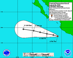
The National Weather Service has issued its first forecast advisory on Tropical Depression 9-E. It is presently located at 106.3 West Longitude and 17.2 North Latitude. By August 27th, as can be seen from the map below, TD 9-E is forcast to move very near the coordinates mentioned in the
Weather Alternative forecast for August 24-28, 2005. This forecast stated "
The potential for tropical storm development is shown in and around 117 West Longitude and 20 North Latitude. This lies in the eastern Pacific about 560 miles southwest of the tip of Baja California." This forecast was prepared at the end of July 2005.
Weather map courtesy of the National Weather Service
No comments:
Post a Comment