 The Weather Alternative post of June 8th made note of the fact that Mars would trigger the Solar Eclipse degree of September 11, 2007. In astrometeorology, solar eclipses are sensitive to the hard aspects of the outer planets for about a 3 year period. The forecast mentioned a sensitive spot about 170 miles south of Guadalajara, Mexico where a tropical system may form. This is roughly 103 west longitude and 18 north latitude.
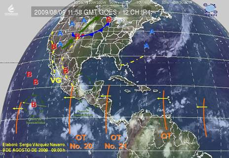
The weather map above from the Mexican Weather Service shows tropical wave #20 over this area on August 9th. (labeled OT No. 20) Their meteorologists reported on Aug 8th Onda tropical No. 20 A lo largo de 100°W y al Sur de 20°N, sobre el Centro y Sur de México, favorecerá fuerte actividad convectiva, con nublados densos y lluvias acompañadas de actividad eléctrica. (Tropical Wave # 10 along 100 west and south of 20 north, over central and southern Mexico, will favor strong convective activity with thick clouds and rain accompanied by electrical activity)
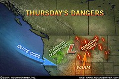
 The forecast also warned of a low pressure system or front affecting the Rockies. The Accuweather map at left for August 6th shows a potent storm system that brought a wide variety of adverse weather. Thunderstorms brought damaging winds, hail, and drenching rain to Idaho and Montana.
 The Weather Channel map at right is for August 7th. Notice the two low pressure systems over the northern Rockies. The Weather Channel reported A vigorous upper-level disturbance moving from the Northwest into the northern Plains will pop more thunderstorms across the Great Basin, Rockies and northern high Plains today.
The thunderstorms could become severe again especially in Montana.
Gusty winds will keep the fire danger high across the Four Corners Region.
Atlantic Hurricane and Southern Texas Rain
Solar Eclipse Action for August and September 2009
August 10-15, 2009
Introduction to the Weather Alternative
How Long-Range Forecasts Are Made
Success and Motive
Your success in life depends on your motive. There is an old fable about a dog that boasted of his ability as a runner. One day he chased a rabbit and failed to catch it. The other dogs ridiculed him on account of his previous boasting. His reply was, "You must remember that the rabbit was running for his life, while I was only running for my dinner." The incentive is all-important.
No comments:
Post a Comment