 Here are the results of a number of long-range weather forecasts for various dates in October. The first was for October 21-24, 2009. The forecast was posted on June 16th of this year.
Forecast
October 21-24, 2009: The transit Sun will make it’s first square to the eclipse degree. The Rockies once again should see a front triggering storms or low pressure area.
Results
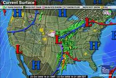
The Accuweather map above is for October 21st showing a low pressure system over the southern Rockies. Heavy snow buried the mountains of southern Colorado and northern New Mexico. Seventeen inches of snow fell near Cuchara, Colorado. Other portions of Colorado received between 4 to 15 inches.
 Another Weather Alternative forecast posted back in June is the following:
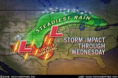
Oct 22-25, 2009: Saturn conjoins the solar eclipse along 88 west longitude, which is roughly the Mississippi Valley area. Since the Gulf of Mexico, and Central America are also affected, this should be a time of strong storms and possible hurricane activity there.
Results
The Weather Channel map (above right) is for October 22nd and shows a strong low pressure area and front affecting the Mississippi Valley. Accuweather reported the area was hit with drenching rain. Moisture from Hurricane Rick enhanced the torrential downpours.
 The forecast also mentioned possible strong storms or hurricane activity in the Gulf of Mexico and Central America.
Nothing tropical developed in the Gulf but, as shown in the Accuweather Map at left for October 22nd, an area of low pressure formed in the southwestern Caribbean causing heavy rain and thunderstorms across Costa Rica, Nicaragua, and Honduras.
 Another forecast for eastern Texas read as follows:
Forecast
Oct 23-24, 2009 ...the weather over eastern Texas at this time should include storms that generate strong winds be they from a tropical system, tornadoes, or severe thunderstorms etc.
Results
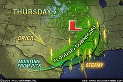
As shown in the Accuweather map for the 22nd (a day before my forecast) eastern Texas was getting flooding downpours. There were tornadoes and damaging wind gusts. (See below)
Accuweather, Oct 22nd: In only 3 hours, 4.29 inches of rain poured down and inundated Fannett, Texas, on Thursday. Arkadelphia, Ark., had 5 inches of rain. High floodwaters stranded motorists and kept firefighters busy with high water rescues. Water was up to windows of cars in Beaumont, Texas. Some communities located along swollen bodies of water had flooding. Many homes and businesses were flooded by up to a foot of water in Farmerville, La. Some of the storms became severe and produced damaging wind gusts on top of the heavy downpours. Tornadoes touched down in the Cameron and Jefferson Davis Parishes of Louisiana during the midday and afternoon hours.

This next forecast was posted in September.
Forecast
Oct 24-26, 2009 Moisture is drawn up over the Plains resulting in storms over the Dakotas and Nebraska.
Results
From Accuwether October 24:
The latest storm system will put a damper on some outdoor plans through Monday (Oct 26) as it spreads rain from the Dakotas and Nebraska to the Great Lakes and Ohio Valley.
The rain will mix with or change over to snow on the western fringe, including in places like Scottsbluff, Neb., Rapid City, S.D., and Bismarck, N.D., through Sunday. Several inches could accumulate in the Black Hills of South Dakota by Sunday.
Introduction to the Weather Alternative
How Long-Range Forecasts Are Made
Solar Eclipse Action October and November 2009
Is Obama Poised to Cede US Sovereignty? Check out these comments by Lord Christopher Monckton
No comments:
Post a Comment