We've had some interesting weather out west in recent days from record-shattering rain in California due to an out-of-season low pressure system, the third-largest wildfire in Arizona's history, and the first tropical depression of 2011. Since this period and area of the country were the focus of my long-range weather forecast for June 3-7, let's see how the forecast turned out.
My May 26 post began by pointing out that on the 3rd of June Mercury would make a 90-
degree or storm-breeding aspect to Neptune at the same time that Neptune began its apparent retrograde motion, which has been observed to coincide with excessive humidity and abundant moisture. I mentioned that these planets affected the western U.S. the Baja Peninsula, and the area around Guadalajara, Mexico. I concluded that the aforementioned areas would receive an influx of moisture due to low pressure systems or fronts. This was definitely the case with the California storm, although I didn't mention California in particular but just the western U.S.
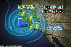
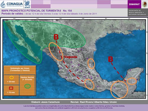
I thought that the Arizona area would see an increase in monsoonal flow bringing abundant moisture. On the contrary, dry and windy conditions have brought one of the largest wildfires to Arizona during this period. What's up with that? While I focused on Neptune's pluvial influence, one of the major ingredients was Mercury's square to Neptune. Mercury is known for its connection with windy conditions and as McCormack stated in his "Astrotech Weather Guide," "Mercury is largely concerned with wind direction and velocity and predicates sporadic strong winds." Looks like I missed that one completely. Throughout the forecast period numerous red flag warnings were in effect for Arizona due to the strong winds. Even the Baja Peninsula, one of the areas I included in the forecast, began the forecast period with warnings for strong winds as shown by the green area on the following map. The map legend relates the green area to "vientos fuertes" or strong winds.
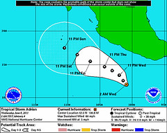
The forecast period ended with the formation of Tropical Storm Adrian. In the forecast I suggested the possibility of the Guadalajara and Baja areas being affected by a tropical system or other type of severe weather. As it stands now, Accuweather commented this morning that one possible path for Adrian takes it toward Mexico somewhere between Jalisco (Guadalajara) and Michoacan or northern Guerrero although it takes it there or near there a bit later than I thought.
June 2011: Long-range Weather Forecasts
Hurricane Hot Spots for June 2011
Neptune and Rockies Flood Potential
Hurricane Season 2011 Baja, Mexico
Hurricane Risk-Management
Hurricane Season 2011 Predictions
Overview of UK Winter 2012-13
The Winters of 2011-14
Cyclone Yasi fulfills long-range prediction!
Tropical Storm Matthew Fulfills Long-range Forecast!
Hurricane Earl and T.D. 10E Fulfill Long-range Forecasts!
Tropical Storm Alex Fulfills Long-range Prediction!
Bonnie Fulfills Long-range Forecast!
Introduction to the Weather Alternative
How Long-Range Forecasts Are Made
Excerpts from Tidal Dynamics by Fergus J. Wood
Science, Health, and Double Blind Studies
Read here

My May 26 post began by pointing out that on the 3rd of June Mercury would make a 90-
degree or storm-breeding aspect to Neptune at the same time that Neptune began its apparent retrograde motion, which has been observed to coincide with excessive humidity and abundant moisture. I mentioned that these planets affected the western U.S. the Baja Peninsula, and the area around Guadalajara, Mexico. I concluded that the aforementioned areas would receive an influx of moisture due to low pressure systems or fronts. This was definitely the case with the California storm, although I didn't mention California in particular but just the western U.S.

I thought that the Arizona area would see an increase in monsoonal flow bringing abundant moisture. On the contrary, dry and windy conditions have brought one of the largest wildfires to Arizona during this period. What's up with that? While I focused on Neptune's pluvial influence, one of the major ingredients was Mercury's square to Neptune. Mercury is known for its connection with windy conditions and as McCormack stated in his "Astrotech Weather Guide," "Mercury is largely concerned with wind direction and velocity and predicates sporadic strong winds." Looks like I missed that one completely. Throughout the forecast period numerous red flag warnings were in effect for Arizona due to the strong winds. Even the Baja Peninsula, one of the areas I included in the forecast, began the forecast period with warnings for strong winds as shown by the green area on the following map. The map legend relates the green area to "vientos fuertes" or strong winds.

The forecast period ended with the formation of Tropical Storm Adrian. In the forecast I suggested the possibility of the Guadalajara and Baja areas being affected by a tropical system or other type of severe weather. As it stands now, Accuweather commented this morning that one possible path for Adrian takes it toward Mexico somewhere between Jalisco (Guadalajara) and Michoacan or northern Guerrero although it takes it there or near there a bit later than I thought.

June 2011: Long-range Weather Forecasts
Hurricane Hot Spots for June 2011
Neptune and Rockies Flood Potential
Hurricane Season 2011 Baja, Mexico
Hurricane Risk-Management
Hurricane Season 2011 Predictions
Overview of UK Winter 2012-13
The Winters of 2011-14
Cyclone Yasi fulfills long-range prediction!
Tropical Storm Matthew Fulfills Long-range Forecast!
Hurricane Earl and T.D. 10E Fulfill Long-range Forecasts!
Tropical Storm Alex Fulfills Long-range Prediction!
Bonnie Fulfills Long-range Forecast!
Introduction to the Weather Alternative
How Long-Range Forecasts Are Made
Excerpts from Tidal Dynamics by Fergus J. Wood
Science, Health, and Double Blind Studies
Read here

No comments:
Post a Comment