The July 28th post entitled General Weather Indications for August 2011 made a number of long-range weather predictions based on planetary cycles also known as astrometeorology. Here is a summary of the weather experienced in order to see how accurate the forecasts were.
Forecast
August 1-4
The gist of this forecast was for heat to affect the Plains and Mississippi Valley along with the chance of some precipitation. Hopefully, Texas would receive some rain.
Results
Record high temperatures were set the first few days of August in Joplin, Mo; Fort Smith, Ar and Salina, Ks to mention a few. Storms, unfortunately, bypassed Texas as shown in the Accuweather map below.
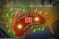

But they did hit throughout the Plains as shown by the following weather headlines:
Aug 1
More Powerful Storms Target Dakotas to Wisconsin
Aug 3
A cold front sparks scattered thunderstorms from the Ohio Valley to western Kansas today.
Forecast
August 9-13, and throughout the rest of August
Low pressure systems and rain was forecast for the 9th through the 13th as well as the remainder of the month. The Accuweather map below shows damaging storms that hit the Northeast on the 9th.
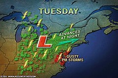

Other weather headlines for the month are shown next:
Aug 13
Heavy Rains In Store From D.C to Boston
Aug 20
Philadelphia Close to All-Time Record Rainfall
Aug 21
Gusty Storms Take Aim at Northeast, mid-Atlantic
Aug 27 - On the last day of the New Moon period Hurricane Irene arrives.
Forecast
August - West Coast
A number of charts showed cooler conditions over the West Coast states during the month of August.
Results
Aug 8
Accuweather posted an article entitled " Tired of the Heat? Head West!" Heat began to return to the area around the 21st.
Forecast
August 16, 21
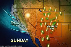
The forecast stated that around the 16th the Pacific Northwest and northern California could see a strong cold front pushing inland, and around the 21st monsoonal moisture might trigger storms in the desert Southwest.
Results
The Weather Channel reported on the 15th that a cold front triggered scattered thunderstorms in eastern Idaho, Montana, northern Utah and northern and western Wyoming.
On the 21st, as shown in the Accuweather map below, storms were possible over the Four Corners region.
Forecast
August 9-11
This forecast warned of a possilbe low pressure system or front approaching off the West Coast.
Results
On the 10th, the Weather Channel reported "A trough of low pressure moves through the Northwest kicking up some late afternoon thunderstorms in eastern Idaho and western Montana."
Forecast
August 20-21
Increasing temperatures and storm systems were indicated for the Dakotas, eastern Montana, and eastern Wyoming.
Results
Here's what conventional forecasters reported:
Aug 21
Showers and thunderstorms possible for much of the Rockies and High Plains today and tonight
Aug 22
South of a vigorous storm crossing western and central Canada, the day will be quite windy across Montana with gusts as high as 40 to 55 mph. Gusty winds will be on the increase across western North Dakota.
Forecast
August 16
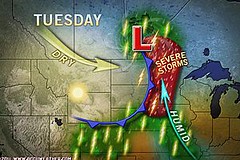
The triple conjunction of the Sun, Mercury, and Venus was to affect the Plains with heat leading to thunderstorms and rain also possible over extreme southern Texas.
Results
As seen from the Accuweather map below for August 16th, strong storms affected the Plains as they also did on the 17th. Extreme southern Texas, however, saw no rainfall.
Forecast
August 21-22
Good rain was supposed to fall on these dates over the Arklatex region.
Results
On the evening of the 20th, strong storms were possible over northern Oklahoma and Arkansas. Then on the 22nd, a few thunderstorms developed from eastern Oklahoma to the lower Mississippi Valley.
Forecast
August 27-28
The forecast indicated a stormy time over the eastern Great Lakes.
Results
A cold front affected the area but the main show was Hurricane Irene a bit further east.
Hurricane Irene Closely Fulfills Long-range Forecast
New Weather Alternative Website
What About Rain For Texas?
Tropical Storm Harvey Fulfills Long-range Weather Prediction!
Hurricane Season 2011 Baja, Mexico
Hurricane Risk-Management
Hurricane Season 2011 Predictions
Overview of UK Winter 2012-13
The Winters of 2011-14
Fulfilled Long-range Forecasts for Hurricane Season 2010
Introduction to the Weather Alternative
How Long-Range Forecasts Are Made
Excerpts from Tidal Dynamics by Fergus J. Wood
No comments:
Post a Comment