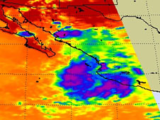
Here are the results of the Dell Horoscope long-range weather forecasts for the first half of September 2011. These forecasts were prepared in February of this year and published in the August edition of Dell Horoscope.
Forecast
Sept 1-3
This forecast expected tropical storm development to take place about 480 miles south of Guadalajara, Mexico or around 103 west longitude and 14 north latitude.
Results
Tropical Depression 8-E formed on the 31st of August and by the 1st of September was at 102 west/18 north.

Here's the report from the National Weather Service.
Tropical Depression 8E
THE REMNANTS OF TROPICAL DEPRESSION EIGHT-E CONTINUE TO PRODUCE
SHOWERS AND THUNDERSTORMS ALONG THE SOUTHWESTERN COAST OF MEXICO.
RE-DEVELOPMENT OF THIS SYSTEM...IF ANY...IS EXPECTED TO BE SLOW TO
OCCUR AS IT MOVES WEST-NORTHWESTWARD AT ABOUT 10 MPH. THIS SYSTEM
HAS A LOW CHANCE...10 PERCENT...OF BECOMING A TROPICAL CYCLONE
DURING THE NEXT 48 HOURS. REGARDLESS OF DEVELOPMENT...HEAVY RAINS
COULD CONTINUE OVER EXTREME SOUTHWESTERN MEXICO DURING THE NEXT DAY
OR SO.
Forecast
Sept 7-10
This forecast warned of possible tropical system over the southern Baja Peninsula and a flare up of tropical activity in the western Gulf of Mexico.
Results
There was no system reported over the Baja at this time but Tropical Storm Nate fulfilled the Gulf forecast as covered in the post Tropical Storm Nate Fulfills Long-range Weather Forecast!
Forecast
Forecast
Sept 1-3
This forecast expected tropical storm development to take place about 480 miles south of Guadalajara, Mexico or around 103 west longitude and 14 north latitude.
Results
Tropical Depression 8-E formed on the 31st of August and by the 1st of September was at 102 west/18 north.

Here's the report from the National Weather Service.
Tropical Depression 8E
THE REMNANTS OF TROPICAL DEPRESSION EIGHT-E CONTINUE TO PRODUCE
SHOWERS AND THUNDERSTORMS ALONG THE SOUTHWESTERN COAST OF MEXICO.
RE-DEVELOPMENT OF THIS SYSTEM...IF ANY...IS EXPECTED TO BE SLOW TO
OCCUR AS IT MOVES WEST-NORTHWESTWARD AT ABOUT 10 MPH. THIS SYSTEM
HAS A LOW CHANCE...10 PERCENT...OF BECOMING A TROPICAL CYCLONE
DURING THE NEXT 48 HOURS. REGARDLESS OF DEVELOPMENT...HEAVY RAINS
COULD CONTINUE OVER EXTREME SOUTHWESTERN MEXICO DURING THE NEXT DAY
OR SO.
Forecast
Sept 7-10
This forecast warned of possible tropical system over the southern Baja Peninsula and a flare up of tropical activity in the western Gulf of Mexico.
Results
There was no system reported over the Baja at this time but Tropical Storm Nate fulfilled the Gulf forecast as covered in the post Tropical Storm Nate Fulfills Long-range Weather Forecast!
Forecast
Sept 9-11
More severe weather was mentioned for the western coast of Mexico around the state of Jalisco.
Results
No system developed here.
Forecast
No system developed here.
Forecast
Sept 11-15
A tropical wave or depression was forecast for the area west of Jamaica in the Caribbean around 80 west longitude and 18 north latitude.
Results
On the 11th a tropical wave west of Jamaica was reported by the National Weather Service over 83 west between 15 and 20 north. Over the next days the wave brought heavy rainfall to Yucatan, Belize, Honduras, and Guatemala. Here's a clip from the National Weather Service on the 13th.
Sept 13
ABUNDANCE OF
TROPICAL MOISTURE COVERS THE ENTIRE CARIBBEAN AND S GULF OF
MEXICO INCLUDING THE YUCATAN PENINSULA AS DEPICTED ON THE TOTAL
PRECIPITABLE WATER IMAGERY. CLUSTERS OF SCATTERED MODERATE TO
ISOLATED STRONG CONVECTION ARE S OF 19N W OF 83W TO INLAND OVER
CENTRAL AMERICA AND THE YUCATAN PENINSULA.
Hurricane Irwin Fulfills Long-range Weather Forecast!
Update on Winter 2011-12
Tropical Storm Nate Fulfills Long-range Weather Forecast!
Tropical Storm Lee Fulfills Long-range Weather Forecast
Hurricane Irene Closely Fulfills Long-range Forecast
New Weather Alternative Website
Tropical Storm Harvey Fulfills Long-range Weather Prediction!
Hurricane Beatriz Fulfills Long-range Weather Prediction!
Hurricane Risk-Management
Hurricane Season 2011 Predictions
Overview of UK Winter 2012-13
The Winters of 2011-14
Fulfilled Long-range Forecasts for Hurricane Season 2010
Introduction to the Weather Alternative
How Long-Range Forecasts Are Made
Excerpts from Tidal Dynamics by Fergus J. Wood

No comments:
Post a Comment