Forecast
Sept 15-17
There is a slight chance that the western Gulf of Mexico could come alive now as Cardinal Solar Ingress Venus is triggered again at longitude and latitude 95 west and 22 north.
Results
National Weather Service
Sept 15
A BROAD UPPER TROUGH COVERS THE REMAINDER OF THE GULF GENERATING SCATTERED SHOWERS/ISOLATED THUNDERSTORMS IN THE BAY OF CAMPECHE WITHIN 75 NM ALONG THE COAST BETWEEN 91W-95W.
Forecast
Sept 16-19
The opposition of Venus and Uranus, and the square between Venus and Pluto may once again threaten the Baja California with severe weather that may be tropical in nature.
Results
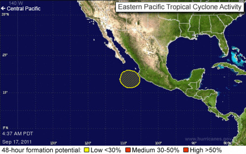
As shown in the maps below for Sept 17th a small area of low pressure formed south of the Baja, which had a 20 percent chance of development.
Forecast
Sept 17-20
Things are not looking good for Hispaniola and the Bahamas as the chance for severe weather or a tropical system is high now.
Results
National Weather Service
Sept 17
A SECOND AREA OF VERY MOIST AIR IS ALONG A SURFACE TROUGH TO THE E ALONG 31N65W 27N72W ACROSS THE CENTRAL BAHAMAS TO 21N77W. STRONG
SHOWERS/THUNDERSTORMS ARE NEAR THE SOUTHERN HALF OF THE TROUGH AXIS
ACROSS THE BAHAMAS FROM 21N-27N BETWEEN 72W-78W...
Sept 18
UPPER LEVEL LOW IS DOMINATING THE ERN CARIBBEAN CENTERED OVER EASTERN
PUERTO RICO.
A SURFACE TROUGH CONTINUES TO SIT OVER THE CENTRAL BAHAMAS...
Sept 19
AN UPPER LEVEL WESTERN ATLANTIC OCEAN TROUGH PASSES THROUGH
32N70W...ACROSS THE CENTRAL BAHAMAS TO 23N76W...ACROSS CENTRAL
CUBA..
Sept 20
CONTINUED UPPER LEVEL TROUGHING OVER THE SW NORTH ATLC
EXTENDS SOUTHWARD INTO THE NE CARIBBEAN AND IS PROVIDING FOR THE
ADVECTION OF TROPICAL MOISTURE NORTHWARD ACROSS HISPANIOLA...
PUERTO RICO...AND THE LEEWARD ISLAND.
Forecast
Sept 17-20
Further north, a severe weather system threatens the U.S. Northeast through New England. It is possible that any tropical system forming or passing through the Bahamas is drawn northward. toward Long Island and New England. Northeast and New England Showers and thunderstorms are ongoing or developing region wide.
Results
Sept 19-20
The Weather Channel
A few 1-inch-or-greater downpours are possible, especially across the Mid-Atlantic Appalachian Mountains.
Forecast
Sept 20-22
A possible tropical system is shown off the west coast of the Baja. This may be part of the system seen in the Sept 16-19 forecast.
Results
No tropical system reported.
Forecast
Sept 21-23
An area of disturbed weather about 325 miles south of Puerto Rico around 66 west longitude and 15 north latitude may show signs of organization now.
Results
Sept 22nd
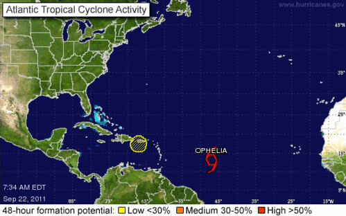
As seen in the graphic below, a weak low was centered over Puerto Rico near 18 north/66 west. Close to the forecast coordinates.
Forecast
Sept 25-28
The Sun and Mercury oppose Uranus and square Pluto. These aspects center over the Baja California and may be indicative of severe weather or a tropical system that is drawn up over the area.
Results
Sept 27
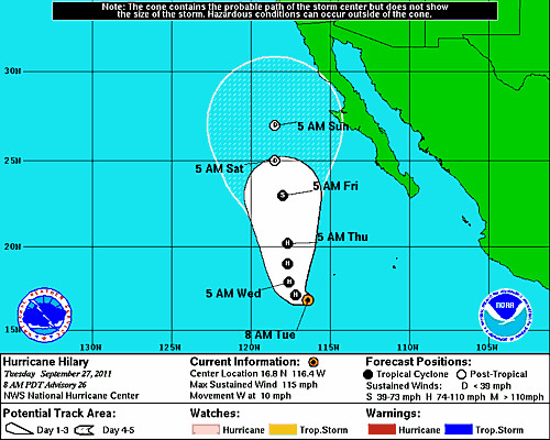
The map below shows Hurricane Hilary approaching the Baja California.
Forecast
Sept 25-28
During this same period, the above aspects set up a broad sensitive area from Jamaica through Cuba and the Bahamas all the way up through the North Carolina coast. This could very well be a tropical system that menaces the Caribbean as it turns and heads up the U.S. coast through the Carolinas.
Results
Sept 25
The Accuweather post for this date says "Worst Weekend Weather in Store for Eastern North Carolina."
Steady bands of rain will continue to move from south to north across the same areas over the next several days in eastern North Carolina. Many cities have already picked up nearly 2 inches of rain, and another 2-4 inches are likely from Emerald Isle to Elizabeth city and points eastward through Tuesday. Isolated amounts of over 6 inches are not out of the question.
Sept 25-26
National Weasther Service reported that an upper level low centered south of the Cayman Islands was generating showers and thunderstorms across Jamaica to the Yucatan and Cuba. On the 26th they reported some heavy showers and thunderstorms across the entire Florida Peninsula into Cuba.
Hurricane Irwin Fulfills Long-range Weather Forecast!
Update on Winter 2011-12
Tropical Storm Nate Fulfills Long-range Weather Forecast!
Tropical Storm Lee Fulfills Long-range Weather Forecast
Hurricane Irene Closely Fulfills Long-range Forecast
New Weather Alternative Website
Tropical Storm Harvey Fulfills Long-range Weather Prediction!
Hurricane Beatriz Fulfills Long-range Weather Prediction!
Hurricane Risk-Management
Hurricane Season 2011 Predictions
Overview of UK Winter 2012-13
The Winters of 2011-14
Fulfilled Long-range Forecasts for Hurricane Season 2010
Introduction to the Weather Alternative
How Long-Range Forecasts Are Made
Excerpts from Tidal Dynamics by Fergus J. Wood
Occupy Wall Street

No comments:
Post a Comment