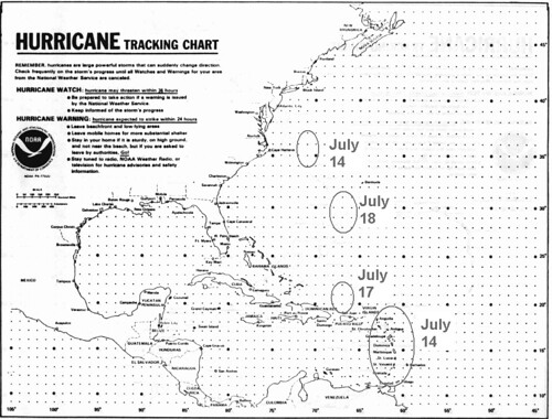
 The above map was included with the forecast and showed the dates and places of possible tropical activity. I had circles the area over the Lesser Antilles and labeled it July 14th. Here's what the National Weather Service reported on this date: TROPICAL WAVE APPROACHING THE LESSER ANTILLES EXTENDS FROM
 20N60W TO 9N56W MOVING W NEAR 20 KT.
I also circled an area off the North Carolina and Virginia coasts to watch around the 14th as well. No tropical activity was reported although conventional meteorologists reported that North Carolina was the target for numerous thunderstorms on the 15th.
Around the 17th, I expected some sort of tropical activity just north of Hispaniola. On the 16th, the National Weather Service reported that a tropical wave was affecting the North Central Caribbean and the Bahamas. This wave along with daytime heating "HAS HELPED FORM CLUSTERS OF STRONG CONVECTION NEAR THE WAVE AXIS. ONE CLUSTER IS ACROSS HAITI FROM 18N-21N BETWEEN 72W-74W." This is basically the area mentioned in the forecast.
On the 18th, I expected an area in and around 30 north latitude and 66-67 west longitude to produce some kind of tropical activity. Here's what the National Weather Service reported happening near there on the 18th.
AN UPPER LEVEL TROUGH IS TO THE E ALONG 30N62W TO AN UPPER LEVEL LOW IN
THE CENTRAL CARIBBEAN. THE UPPER TROUGH SUPPORTS SOME ISOLATED
SHOWER/POSSIBLE THUNDERSTORMS FROM 120 NM EITHER SIDE OF A LINE
FROM HISPANIOLA TO 29N62W.
On the 19th it was over 29N65W. I, of course, was expecting stronger storm systems to manifest over these areas. So these tropical waves and upper level lows were small potatoes compared the storms that hit New England on the 17th and 18th. I had expected either a tropical system to lash the area or some other type of severe weather to do so. The Accuweather map below is for the 18th.

Accuweather said on the 17th that these beastly storms had the potential to produce intense gusts of wind, hail larger than quarters, and torrential, blinding downpours as well as perhaps spawn a tornado or two from New York state through New England. On the 18th, their headline ran: Vicious Storms Wednesday: Boston, NYC, Philly, DC.
Olympics Weather July 27- August 12, 2012
Mars Conjunct Saturn August 15, 2012
Jupiter-Neptune and Heavy Rain
The Solar Eclipse of November 13, 2012
Long-range effects of the May 20, 2012 Solar Eclipse
Long-range effects of the May 20, 2012 Solar Eclipse Part 2
July 20-29, 2012 Long-range Weather Forecast
Hurricane Season 2011 Forecast Results
Hurricane Risk-Management
Texas Summer 2012
New Weather Alternative Website
Overview of UK Winter 2012-13
The Winters of 2011-14
Fulfilled Long-range Forecasts for Hurricane Season 2010
Introduction to the Weather Alternative
When you change the way you look at things, the things you look at change.”
― Wayne W. Dyer
No comments:
Post a Comment