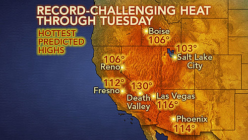
I noted that on July 1st, Mercury was going to trigger the Mercury-Venus conjunction. I mentioned how this could excite windy conditions and also draw a warm, moist air mass from the south over the West Coast. The Sun was then to trigger the Uranus-Pluto square of the previous May on July 2nd. This influence was to lower temperatures and bring windy and stormy conditions. Putting it all together, I thought we could see a strong front bringing stormy conditions or a wind event such as Santa Ana winds.
Results
The weather pattern that developed did not follow my synthesis exactly but the main elements were present. For example, on July 1st, Accuweather published the following weather map showing the temperatures experienced in the historic heat wave that was developing. This corresponds to the warm, moist air mass drawn up from the south (although more warm than moist).

On July 2nd, Accuweather then publish the next map with their post entitled "Historic Heat to Ease Temporarily in West." They pointed out how that starting on July 4th a dip in the jet stream would diminish the heat. This corresponds to the Sun-Uranus-Pluto influence that was to bring lower temperatures.

Although the West did not experience a Santa Ana wind event, there were winds to be dealt with. On July 1st, Accuweather also reported "Wind-Whipped Arizona Wildfire Kills 19 Firefighters." The National Weather Service also posted numerous Gale Warnings for Washington, Oregon, California coasts. In addition, the NWS in Oregon warned in a Fire Weather Message on July 2nd "WINDY CONDITIONS AND LOW RELATIVE HUMIDITY IN THE COLUMBIA
BASIN WEDNESDAY AND FOR THE FOURTH OF JULY." A similar message was posted on the 3rd for Washington.
June
I made a number of forecasts regarding the developing California water shortage in a two part post. (here and here) I have yet to post the results of Part 1 but have looked at the results of Part 2. The first one is posted here. Now we'll look at the last forecast posted in Part 2. That forecast was for the period of June 7-12. I concluded that with Neptune and the Sun affecting the area off California coast, we should experience a chance of precipitation for the West Coast.
Results
The Weather Channel reported on June 9th that an upper-level low from off the California coast would punch into Nevada triggering scattered thunderstorms. Unfortunately, lightning strikes could potentially start fires.
By the 11th, a low-pressure area entered the Pacific Northwest causing showers and thunderstorms for a couple of days.
Hurricane Season 2013 Part 1
West Coast Weather July-August 2013
Tropical Storm Andrea Fulfills Long-range Forecast!
California Water Shortage Part 2
California Water Shortage Spring 2013 Forecast
Timing the Relief for Drought-Stricken U.S. Plains
Testing Astrometeorology Part 2
Hurricane Sandy Fulfills Long-range Weather Prediction!
Testing Astrometeorology Part 1
Long-range effects of the May 20, 2012 Solar Eclipse
Long-range effects of the May 20, 2012 Solar Eclipse Part 2
Hurricane Season 2011 Forecast Results
Hurricane Risk-Management
New Weather Alternative Website
Overview of UK Winter 2012-13
The Winters of 2011-14
Fulfilled Long-range Forecasts for Hurricane Season 2010
Introduction to the Weather Alternative
Monument to Atheism (click here to read)

No comments:
Post a Comment