Monday, October 09, 2006

Stormy West and Rockies

Click here for October 2006 Hurricane and Severe Weather Outlook

Click here for the Introduction to The Weather Alternative

Scroll down to see more long-range forecast results

Here's another long-range forecast issued by The Weather Alternative at the end of September that's shaping up:

Oct 8-10:
A storm system moves in over the West Coast States and pushes toward the Rockies.


The Weather Channel reports today that:

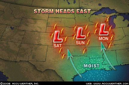
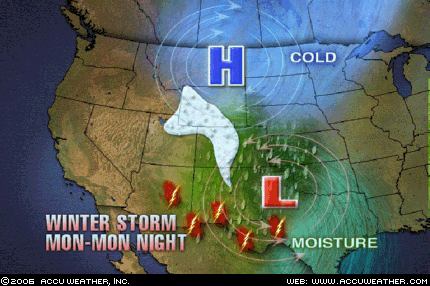
Two disturbances will bring wet weather to a large part of the West on Monday. An upper low over western Arizona will pump moisture into the Four Corners region and across the Rocky Mountains.
As a result, look for showers and thunderstorms across Arizona, New Mexico, Utah, and Colorado.
Flood watches are in effect for portions of Utah and Colorado as some of the rain could be locally heavy.

Farther north, another disturbance will trigger snow across the Northern Rockies. Snow advisories and winter storm warnings are in effect for parts of Montana and Wyoming, and some mountain locations could see a foot of snow.

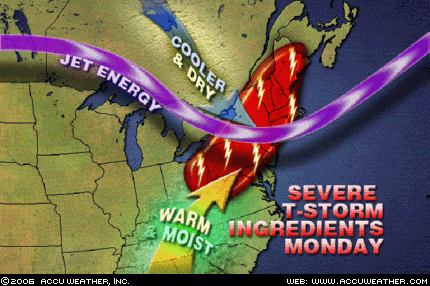
Weather graphic courtesy of Accuweather

Saturday, October 07, 2006

Coming Cold Wave

Click here for October 2006 Hurricane and Severe Weather Outlook

Click here for the Introduction to The Weather Alternative

Conventional meteorologists over the last few days have been warning us of a very powerful cold front that will push southward over the Plains and move toward the east. Here's the latest from Accuweather:
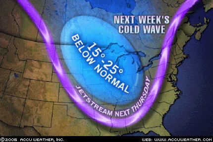
...a blast of cold air...will reach the Plains Wednesday (11th) of next week. A sharp cold front from northern Canada will bring temperatures 15 to 25 degrees below normal, and combined with a strong wind, a drastic change will be on the horizon. Showers and thunderstorms ahead of this cold front will pass through the Plains and into the east. Some locations will receive their first snow of the season behind this cold front as rain will change to snow across the northern Plains, northern Great Lakes, as well as the northern Rockies.
This cold blast will reach southward into the southern Plains and push eastward toward the Atlantic coastline.


This will be a direct fulfillment of The Weather Alternative's October 10-12, 2006 forecast posted at the end of September, which read:

Storms should rev up over the Plains and West Coast. After the 12th, falling temperatures and windy conditions are in store for the eastern U.S.

Wednesday, October 04, 2006

Coastal Storm Approaches

Click here for October 2006 Hurricane and Severe Weather Outlook

Click here for the Introduction to The Weather Alternative

The Weather Alternative forecast for October 5-7, 2006 was prepared in December 2005 and stated "Storms hit from coastal North Carolina and Virginia through the Northeast."

Today Accuweather confirms this long-range forecast.

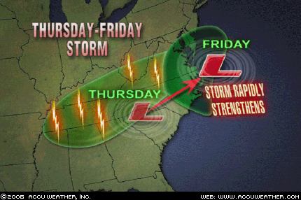
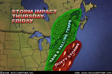
Following summer's brief return, a coastal storm will batter the central Atlantic states as the workweek draws to a close. After causing showers and thunderstorms to rumble across the Northeast, a cold front will drop into the Tennessee Valley on Thursday (5th). Instead of making a quick passage through the region, an area of low pressure will slow down the front's southward progress. To complicate matters, a strong upper-level storm system will also dive into the region, allowing the low pressure to rapidly intensify as it moves off the North Carolina coast on Friday (6th). As the storm interacts with a strong area of high pressure to the north, the southeastern mid-Atlantic states and northeastern North Carolina will be pounded with heavy rain and high winds Friday into Friday night.

The Weather Alternative also issued some other forecasts for this same time period.

A tropical moisture is indicated over the Bahamas, Cuba, and Jamaica.

Jamaica's Meteorological Service issued the following statement today:

Thur..Tropical Wave passes over the island.

Fri..Surface to upper level trough over Bahamas and Cuba.

Sat..Surface to upper level trough over Bahamas and Cuba.

A storm system will advance into the Pacific Northwest and Intermountain West, pushing showers and thunderstorms into those areas.

Accuweather reported today:

The West will also be wet, thanks to a slow moving upper-level low located off the coast of Northern California. As this low works closer to the coast tonight, colder air will be drawn south into California, lowering snow levels in the northern and central Sierra Mountains to 6,000 feet.

Thursday, September 28, 2006

October 2006 Hurricane and Severe Weather Outlook

Click here for September 2006 Hurricane and Severe Weather Outlook

Click here for the Introduction to The Weather Alternative

Scroll down and check out fulfilled long-range forecast.

Oct 4-6:
A cold front over the Mississippi Valley triggers storms that push eastward.

Oct 5-7:
Storms hit from coastal North Carolina and Virginia through the Northeast.
A tropical moisture is indicated over the Bahamas, Cuba, and Jamaica.
A storm system will advance into the Pacific Northwest and Intermountain West, pushing showers and thunderstorms into those areas.

Oct 7-9:
Cold air funnels in over the Plains and pushes eastward triggering storms that eventually reach the Southeast, Mid-Atlantic, and Northeast.

Oct 8-10:
A storm system moves in over the West Coast States and pushes toward the Rockies.


Oct. 10-12:
Storms should rev up over the Plains and West Coast. After the 12th, falling temperatures and windy conditions are in store for the eastern U.S.

Oct 11-13:
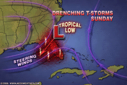
Low pressure brings rain to the Bahamas, Cuba, and Jamaica. Storms will affect the coastal area of Florida, Georgia, and South Carolina.

Oct. 15-18:
The general weather pattern over California begins to change now as a warmer more moisture-laden air mass enters the region. This may result in tropical moisture being funneled into the area setting off heavy showers. Fog may also be a concern now.
Abundant moisture is also drawn up over the Plains creating severe weather potential along the Front Range of the Rockies.
The Mid-Atlantic States will have to deal with what promises to be some good-sized storms of their own.

Oct 19-21:
Showers and storms hit the Northeast down through Virginia, the coastal areas of Florida, Georgia, and South Carolina, as well as the Bahamas, Cuba, and Jamaica.


Oct. 19-21:
Storms continue to kick out into the Plains as contrasting air masses feed low pressure systems. The West Coast gets a new round of storms while temperatures drop over the eastern U.S.

Oct. 22-25:
A new wave of inclement weather reaches the West Coast States. The period climaxes with the potential for tempestuous, widespread storms and heavy downfall. The Plains should respond with an outbreak of severe weather, which may include possible tropical storm implications along the southwest coast of Texas.
The potential for major tropical activity is also shown for the eastern coast of India.
The eastern U.S. should be dealing with its own weather anomalies as temperatures skyrocket. The atmosphere may try and equalize the situation by unleashing strong storms over the Southeast and Mid-Atlantic regions. A tropical system cannot be ruled out.
Another Hurricane Hot Spot may develop off the eastern coast of Nicaragua threatening Central America, while the island of Jamaica is in for severe weather as well.

Oct 25-27:
A vigorous low pressure system will trek across the Rockies generating strong storms.


Oct 28-30:
A low pressure system off the California coast will hurl wind and rain into California and Oregon. Major changes should be underway for the Plains as well. A whirling dervish of a storm center over northern Minnesota and Wisconsin will most likely usher in windy conditions. Tropical moisture from the Gulf will help ignite hefty storms over the Ark Latex region.
A Hurricane Hotspot forms in the Eastern Pacific at 94 West Longitude and 10 North Latitude or about 400 miles south of Oaxaca, Mexico.

Wednesday, September 27, 2006

Soaking Rain for the Northeast

Click here for September 2006 Hurricane and Severe Weather Outlook

Click here for the Introduction to The Weather Alternative

The Weather Alternative's long-range forecast (prepared in December 2005) for September 26-28 is shaping up just fine. The forecast called for The potential for heavy rainfall is shown over the eastern US from the eastern Great Lakes southward to Virginia.

Here's the latest from Accuweather:

The front moving through the Great Lakes today will reach Pennsylvania and western New York by Thursday, bringing cloudy, damp weather and noticeably cooler air. The wettest weather in the coastal mid-Atlantic will come on Thursday night, and Friday looks like a washout for New England. To add insult to injury, the upper-level trough that is pushing this front along will be lifting up to the north, meaning the front will be slowing down. So, while places in the Great Lakes will just be having a quick spell of rain today, much of the Northeast will have a soaking rain for a longer period of time.

Sunday, September 24, 2006

Strong Storms for Eastern US

Click here for September 2006 Hurricane and Severe Weather Outlook

Click here for the Introduction to The Weather Alternative

The strong storms affecting the US East Coast are a direct fulfillment of the following long-range weather forecast. This forecast was prepared in December 2005, published in the July 2006 edition of Dell Magazine and posted on this blog in August 2006.

Forecast

Sept. 24-26:
A blast of cold air will assault the Mid-Atlantic and Southeast generating gusty winds and slashing temperatures.

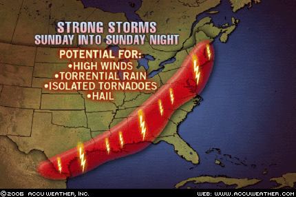
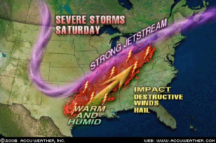
Today Accuweather published the following map and comment.


The storm system that has pounded the Midwest and Mississippi Valley with severe weather recently will sweep southward and eastward this afternoon, spreading the severe weather threat from Bangor, Maine, to Albany, Georgia, and into Brownsville, Texas. The AccuWeather.com Severe Weather Center is urging residents or visitors across these areas to keep an eye to the sky and check back to AccuWeather.com as any of these thunderstorms has the potential to produce damaging winds, heavy rain and hail. In addition, isolated tornadoes cannot be ruled out.

In addition to the above forecast, The Weather Alternative also forecast the following:

Sept. 23-25:
A tropical weather system may be brewing near the Dominican Republic and tropical moisture unloads over the Florida Panhandle.

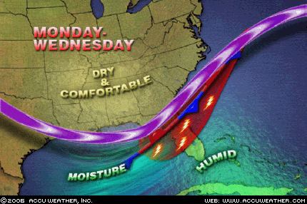
Accuweather reports: A frontal boundary will stall across northern and central Florida through the middle of the week. Moist air will continue to spread up along the front from Monday to Wednesday, leading to widespread showers and thunderstorms. The heaviest rainfall during the period will likely be from Gainesville to Orlando, Fla.


The National Weather Service published the following about the Dominican Republic:

TROPICAL WAVE IS OVER THE LESSER ANTILLES ALONG 62W S OF 20N MOVING SLOWLY WESTWARD AT AROUND 10KT. BROADENING INVERTED-V SIGNATURE CURVATURE WITH SCATTERED SHOWERS/ISOLATED THUNDERSTORMS FROM 13N-18N BETWEEN 58W-64W. THIS WAVE WILL MOVE ACROSS THE VIRGIN ISLANDS AND PUERTO RICO LATE TODAY TROUGH MONDAY AND IS EXPECTED TO REACH DOMINICAN REPUBLIC MONDAY AFTERNOON OR EVENING...INCREASING THE CHANCE OF RAIN OVER THOSE ISLANDS.

Thursday, September 21, 2006

Large Storm for Central U.S.

Click here for September 2006 Hurricane and Severe Weather Outlook

Click here for the Introduction to The Weather Alternative

Conventional meteorologists, over the last couple of days, have realized that a potent storm system is taking shape over the Central U.S. This was forecast by The Weather Alternative back in December 2005 and posted this blog on August 24, 2006. The forecast is repeated below.

Forecast

Sept. 21-23:

The insurgence of warm, moist air over the Gulf Coast States from Texas to Florida will act as a potential storm breeder on its journey northward into the central U.S.


Graphic by Accuweather.com

Sept 21, 2006- The Weather Channel

A soaking inch-plus rain will extend from the Dakotas to the western Great Lakes. Thunderstorms will be ongoing or developing from the eastern sections of the central Plains, across the mid-Mississippi Valley, to the Ohio Valley. With a strong energetic jet stream from Kansas to Lower Michigan, warming temperatures and a plentiful return of moisture from the Gulf, severe thunderstorms with hail, damaging wind gusts and tornadoes will erupt over Iowa, Missouri and Illinois Friday. Winds will be strong and gusty over the northern Plains, Mississippi Valley, western Great Lakes and Ohio Valley.

Tuesday, September 19, 2006

September 16-17, 2006 Forecast Results

Click here for September 2006 Hurricane and Severe Weather Outlook

Click here for the Introduction to The Weather Alternative

Forecast (prepared December 2005)

Sept. 16-17:
A potential tropical disturbance may get its act together over Cuba and Florida. A low pressure system will develop over the Front Range of the Rockies.

Results

A potential tropical disturbance may get its act together over Cuba and Florida.

Sept 16, 2006- Accuweather

A lingering frontal boundary across the southern peninsula of Florida will yield a few showers and thunderstorms, but at least there are no tropical systems to worry about.

A low pressure system will develop over the Front Range of the Rockies.


Sept 16, 2006- Accuweather

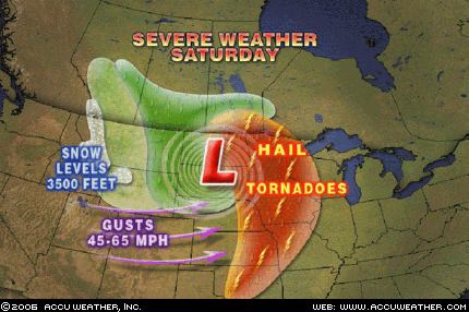
A strong storm system will dive into the northern Plains today setting the stage for a wide variety of weather… thunderstorms will become severe today with hail and even isolated tornadoes battering eastern Nebraska, western Iowa and northward into the eastern Dakotas and western Minnesota. This cold front will also lead to strong winds through the central Rockies today with gusts 45- to 65 mph. A few gusts past 70 mph could whip through canyons and gorges of the front range in Colorado and Wyoming.

Monday, September 18, 2006

September 14-16, 2006 Forecast Results

Click here for September 2006 Hurricane and Severe Weather Outlook

Click here for the Introduction to The Weather Alternative

Most of these forecasts were prepared in December 2005.

Forecast

Sept. 14-16:
Tropical activity is shown for the area in and around Puerto Rico. Meanwhile, a new cold front hits the West Coast States dropping temperatures and increasing moisture.The Mississippi Valley and eastward will be the focal point for windy and stormy conditions.

Results

Tropical activity is shown for the area in and around Puerto Rico. (66 West/18 North)

Sept 14, 2006- NWS

TROPICAL WAVE IS ALONG 64W/65W S OF 18N MOVING W 15 KT...SCATTERED MODERATE/ISOLATED STRONG CONVECTION IS FROM 14N18N BETWEEN 63W-66W.

Meanwhile, a new cold front hits the West Coast States dropping temperatures and increasing moisture.

Sept 14, 2006- The Weather Channel
West

A significant upper level disturbance will move into the Northwest today, in the wake of a cold front that passed through yesterday. With this disturbance in the area, and much cooler air moving in, scattered showers will develop during the afternoon hours.

Sept 15, 2006- The Weather Channel
West
The unusually intense storm and early season cold snap will continue to work its way across the West this weekend on its way to engulf most of the nation.

The Mississippi Valley and eastward will be the focal point for windy and stormy conditions.

Sept 15, 2006- The Weather Channel
A giant early season storm with hints of the winter to come will take control of the north-central U.S. this weekend. A strong cold front will kick off this fast-forward to late fall as it plows eastward from the Plains to the Appalachians over the next 3 days.

Severe thunderstorms with hail, damaging winds and a few tornadoes will develop Saturday from the eastern Dakotas, Minnesota and western Wisconsin to eastern Kansas and Missouri. Some severe thunderstorms will continue across Illinois and Missouri on Sunday. As the front reaches Michigan and the Ohio Valley Monday, the thunderstorms will shift eastward across the remainder of the Midwest.

While strong warm southerly winds have gusted in advance of the front, equally strong northerly and northwesterly winds will further enhance the cold over the Plains and Midwest once the front moves through.

Thursday, September 14, 2006

September 12-14 Forecast Results

Click here for September 2006 Hurricane and Severe Weather Outlook

Click here for the Introduction to The Weather Alternative

Forecast:

Most of these forecasts were prepared in December 2005.

Sept. 12-14:
Gusty winds hit the Plains, and storms affect the Mid-Atlantic, Northeast and New England. These storms over the eastern U.S. should bring abundant moisture and cause flooding problems. The culprit may be a tropical system drawn up over North Carolina or Virginia.Moisture increases over the southern California area. A front triggers showers and storms over the Rockies.Heavy rain is indicated for the island of Hispañola, which may be due to some type of tropical system.

Results

Gusty winds hit the Plains...

Sept 14, 2006- The Weather Channel

Windy conditions will develop over the central and high Plains in response to a low pressure moving toward that area.

...and storms affect the Mid-Atlantic, Northeast and New England. These storms over the eastern U.S. should bring abundant moisture and cause flooding problems. The culprit may be a tropical system drawn up over North Carolina or Virginia.

Sept 12, 2006- Accuweather

As this storm heads east, a wave of low pressure is forecast to develop along the front as it moves across Georgia late on Wednesday. That will enhance rainfall across the Carolinas and southeastern Virginia. The ground in this area remains saturated from heavy rainfall from Tropical Storm Ernesto, and there is some concern that localized flooding could occur in this area Thursday.

Sept 14, 2006- The Weather Channel

Northeast
An area of low pressure will spread rain across the Middle Atlantic into the Northeastern States today, some of which could be heavy at times.

Moisture increases over the southern California area.


Sept 14, 2006- Accuweather

Along the coastline, a thickening marine layer will prolong the low clouds, fog and drizzle along the coastline of California.


A front triggers showers and storms over the Rockies.

Sept 14, 2006- National Weather Service

THIS HAZARDOUS WEATHER OUTLOOK IS FOR WESTERN AND CENTRAL WYOMING

..DAY ONE...TODAY AND TONIGHT STRONG AND GUSTY WEST TO SOUTHWEST WINDS OF 20 TO 35 MPH ARE EXPECTED ACROSS WESTERN AND CENTRAL WYOMING THROUGH THIS EVENING AS A POWERFUL STORM SYSTEM CONTINUES TO DEVELOP OVER THE PACIFIC NORTHWEST.

AHEAD OF THIS SYSTEM THUNDERSTORMS WILL BE ON THE INCREASE THROUGH THE EVENING HOURS...ESPECIALLY ACROSS SOUTHWEST WYOMING. SOME OF THESE STORMS COULD PRODUCE WIND GUSTS TO 50 MPH...SMALL HAIL...BRIEF HEAVY RAIN AND DANGEROUS CLOUD TO GROUND LIGHTNING. A LIGHT ACCUMULATION OF SNOW IS POSSIBLE ABOVE 9000 TO 10000 FEET.

Heavy rain is indicated for the island of Hispañola, which may be due to some type of tropical system.

Sept 14, 2006- Dominican Republic Weather Service

A tropical wave is located over the Mona Passage moving westward at 26 kph. A mid to upper level low is in the troposhpere over the island.


Saturday, September 09, 2006

Stormy West Coast and Plains

Click here for September 2006 Hurricane and Severe Weather Outlook.

Click here for the Introduction to The Weather Alternative

The Weather Alternative long-range forecast for Sept 8-9, 2006 called for a stormy period for the U.S. West Coast and Plains. These forecasts were prepared during December 2005.

The Plains
Here are the latest reports from Accuweather .com:

A storm system will take shape today across the west-central Plains and then head northeastward into Illinois by Monday. This storm will tap into moist Gulf of Mexico air, allowing for rain and thunderstorms to spread on eastward with it. In the area just south of the warm front and east of the cold front, enough instability will be around along with favorable jet steam energy to allow for a few storms to be locally severe with gusty winds and hail. The best threat for a severe storm today will be in western Oklahoma and the Texas Panhandle. By tomorrow, the threat will shift into central and eastern Kansas into Missouri, and by Monday into parts of southern Illinois.

The West Coast

Sept 8, 2006- Accuweather

The wildfire danger remains at a critical level in the Northwest interior. A cold front moving into the region will bring cooler temperatures and higher humidity. However, dry thunderstorms developing ahead of the front could spark more fires, and gusty winds associated with the cold front could help to spread existing fires.

A disturbance in the upper levels of the atmosphere has been causing heavy rainfall the past couple of days over the Southwest and southern Rockies.

Thursday, August 31, 2006

More Fulfilled Hurricane Predictions

Click here for September 2006 Hurricane and Severe Weather Outlook.

Click here for August 2006 Hurricane and Severe Weather Outlook.

Besides accurately predicting the time and place of Ernestos' landfall (click link), a close Weather Alternative forecast for hurricane activity over the Baja California is being fulfilled.
Hurricane John will begin to affect the Baja tomorrow. (These forecasts were prepared in December 2005)

The forecast read:

Aug. 28-30:

Tropical storm formation is possible over the central Baja Peninsula.

Today the Weather Channel reported:
After its close encounter with Mexico's southwest Pacific coast, John will then head towards the southern Baja Peninsula by Friday afternoon remaining as a Category 3 hurricane. A hurricane warning is in effect for the Southern Baja Peninsula from Las Pas southward on the East Coast and from Santa Fe Southward on the West Coast. This does include Cabo San Lucas. Reports are indicating that 10,000 people have been evacuated in and around the Los Cabos beach resort in preparation for John's arrival.


Hurricane Kristy is the fulfillment of another long-range forecast published in the July issue of Dell Magazine (not posted on this blog).

The forecast read:

August 30-Sept 1:
A Hurricane Hot Spot in the eastern Pacific is likely to develop near 119 West Longitude and 16 North Latitude...

The National Weather Service reported on August 30th:

TROPICAL STORM KRISTY CENTERED NEAR 16.7N 115.1W AT 30/1500 UTC MOVING NW OR 305 DEG AT 5 KT.

Monday, August 28, 2006

Ernesto Fulfills Long-Range Prediction


Click here for September 2006 Hurricane and Severe Weather Outlook.

Click here for August 2006 Hurricane and Severe Weather Outlook.

The Weather Alternative Forecast for August 28-30, 2006 stated "Tropical troubles are still brewing over a broad area from western Cuba through western Florida and into Georgia and South Carolina." This forecast was prepared in December 2005 and posted on The Weather Alternative July 23, 2006.

Today Tropical Storm Ernesto is hitting southern Cuba. A Hurricane Watch has been issued for parts of mainland South Florida.

Sunday, August 27, 2006

August 19-22, 2006 Forecast Results

Click here for September 2006 Hurricane and Severe Weather Outlook.

Click here for August 2006 Hurricane and Severe Weather Outlook.

Forecast for August 19-22, 2006

These forecasts were developed during the first two weeks of December 2005.

Aug. 19-22:

Several atmospheric ingredients will come together over the Southeastern States from the Big Bend of Florida into Georgia creating a threat of severe weather. The threat will extend into the Ohio Valley as well. It is possible that this signifies a tropical system or at least abundant tropical moisture that drops heavy rain over the Southeast.

Results

August 19, 2006- Accuweather

The cold front that triggered these storms is steadily moving east and showers and strong storms are expected later today across the Ohio Valley and into the eastern Great Lakes.

August 19, 2006- Map by Accuweather


August 21, 2006- Accuweather

Drenching Southern Storms

(State College, PA) - The front that brought soaking rain to parts of the Northeast over the weekend is stalling in the South. AccuWeather.com is forecasting that showers and thunderstorms through the end of the week may lead to localized flooding problems.

August 16-18, 2006 Forecast Results

Click here for September 2006 Hurricane and Severe Weather Outlook.

Click here for August 2006 Hurricane and Severe Weather Outlook.

Forecast for August 16-18, 2006

These forecasts were developed during the first two weeks of December 2005.

Aug. 16-18:
A strong storm system is indicated over New England and the Canadian Maritimes as energy moving from the west interacts with a warm, moist air mass.

Results

Aug 19, 2006- Weather Channel (Storms arrived a day later than my forecast period)
Northeast

High pressure moving to the east will allow a storm system to approach from the west. Numerous showers and thunderstorms will spread across western New England and the Upper Ohio Valley today, along with the potential for an isolated severe thunderstorm or two, as well as heavy downpours and localized flooding.

Thursday, August 24, 2006

September 2006 Hurricane and Severe Weather Outlook

Click here for August 2006 Hurricane and Severe Weather Outlook.

Most of these forecasts were prepared in December 2005.

August 30-Sept 1:
Look for increasing moisture over the southern California coast resulting in foggy conditions or rain.
Storms will be active over the Rockies.

Sept. 2-5:
A potential Hurricane Hot Spot is activated off the eastern coast of Mexico in the Gulf around the 2nd or 3rd. At the same time, a broad area encompassing the central Caribbean, Cuba, Florida, and the Carolinas may be the breeding grounds for more tropical activity.

Sept. 3-5:
Changes are also underway for the West Coast States and the Rockies. Look for lower temperatures and windy conditions there. The New England area should expect strong storms that head to the Canadian Maritimes.
A tropical disturbance may flare up over the Bahamas.

Sept. 5-7:
More moisture is drawn up over southern California resulting in an increased chance of showers and thunder storms.
The Rockies warm up as winds from the south increase temperatures and precipitation.
Texas and the Plains at this time will deal with unseasonable heat that cranks up the storm machine over the area.

Sept 6-8:
Tropical troubles may be brewing for the island of Hispañola and surrounding areas.
The US East Coast will attract a tropical flow over Virginia and northward through the eastern Great Lakes. If not an actual tropical system, strong storms will drop heavy rain with the potential for flash flooding and bring windy conditions.

Sept. 8-9:
A stormy period continues for the U.S. West Coast and the Plains.

Sept. 12-14:
Gusty winds hit the Plains, and storms affect the Mid-Atlantic, Northeast and New England. These storms over the eastern U.S. should bring abundant moisture and cause flooding problems. The culprit may be a tropical system drawn up over North Carolina or Virginia.
Moisture increases over the southern California area. A front triggers showers and storms over the Rockies.
Heavy rain is indicated for the island of Hispañola, which may be due to some type of tropical system.

Sept. 14-16:
Tropical activity is shown for the area in and around Puerto Rico. Meanwhile, a new cold front hits the West Coast States dropping temperatures and increasing moisture.
The Mississippi Valley and eastward will be the focal point for windy and stormy conditions.

Sept. 16-17:
A potential tropical disturbance may get its act together over Cuba and Florida. A low pressure system will develop over the Front Range of the Rockies.

Sept 19-21:
Storm potential is shown for the island of Hispañola and the Mid-Atlantic through the Northeast.

Sept 20-22:
Heavy downpours are shown over the Florida Peninsula and western Cuba.

Sept. 21-23:
The U.S. West Coast shows severe weather in the form of extreme temperature changes and/or storms.

The insurgence of warm, moist air over the Gulf Coast States from Texas to Florida will act as a potential storm breeder on its journey northward into the central U.S.

Severe storms will break out over the Mid-Atlantic States and Northeast.

Sept. 23-25:
A tropical weather system may be brewing near the Dominican Republic and tropical moisture unloads over the Florida Panhandle.

Sept. 24-26:
A blast of cold air will assault the Mid-Atlantic and Southeast generating gusty winds and slashing temperatures.
A new Hurricane Hot Spot emerges for the fall portion of the hurricane season off the coast of Africa. The formation of a significant tropical system is possible now along the African West Coast around 18 West Longitude and 18 North Latitude, which should move westward toward 31 West-16 North.
Another danger spot is shown along the eastern Central American coast of Belize, Guatemala, and Honduras.
Noteworthy weather events are in store for the U.S. West Coast bringing abnormally wet conditions. Such will be the case for coastal California especially around the 26th when an influx of tropical moisture is drawn northward over the State from southern regions. The western Plains carry the potential for excessive humidity and abnormal rainfall to dominate now and move eastward through the Mississippi Valley.

Sept 26-28:
The potential for heavy rainfall is shown over the eastern US from the eastern Great Lakes southward to Virginia. Storms are indicated for the Plains.

Sept. 28-30:
The Central Gulf of Mexico may spawn a tropical disturbance that is drawn up over the Mississippi-Alabama costal area and into the Deep South. If not an actual tropical system, at the least tropical moisture should be funneled into the area from the Gulf. Rain is indicated over the Florida Peninsula. Low pressure may form off the Baja sending moisture over southern California.

Sept. 29-Oct. 1:
A tropical system may be indicated between Puerto Rico and the Lesser Antilles now.
Monday, August 21, 2006

August 14-15, 2006 Forecast Results

Click here for August 2006 Hurricane and Severe Weather Outlook.

These forecasts were developed during the first two weeks of December 2005.

Forecast

Aug 14-15:
Meteorological mayhem breaks out over the Southeast U.S. through the Ohio Valley as atmospheric elements combine over the area. One scenario shows a tropical system approaching the west coast of Florida and pushing inland with soaking rains. Another model suggests strong storms with damaging winds and flooding.

Results

August 14, 2006- The Weather Channel

A few severe storms Ohio Valley Monday

A stalled front off the coast of northeast Florida may drift slightly southward into an area of lower wind shear aloft over the next day or two. This could provide the opportunity for a tropical or subtropical low pressure system to develop somewhere along the front in the vicinity of enhanced thunderstorms over the Gulf Stream.


August 16, 2006- The Weather Channel

A flare-up of heavy showers associated with a low pressure center about 125 miles southeast of Myrtle Beach, S. C., is being monitored closely. Air force reserve Hurricane Hunters are tasked to investigate the disturbance this afternoon. It's possible a tropical depression could form later today or tonight if the convection--the heavy showers--persists. Upper-level winds are light (minimal wind shear) and the disturbance is near the Gulf Stream (plenty of warm water).

Sunday, August 20, 2006

August 11-13, 2006 Forecast Results

Click here for August 2006 Hurricane and Severe Weather Outlook.

There forecasts were prepared during the first two weeks of December 2005.

Forecast

Aug. 11-13:
Gusty winds will prevail along the West Coast with storm potential further inland.

Results

August 11, 2006- Accuweather

Farther south, it will continue to be active across the Southwest, mainly in Arizona, New Mexico and Colorado, as monsoonal moisture streaming into the area will spark the development of thunderstorms. Some storms will dump heavy rains that could create a threat of flash flooding.

AREA FORECAST DISCUSSION
NATIONAL WEATHER SERVICE MEDFORD OR
858 PM PDT SAT AUG 12 2006

.DISCUSSION...LITTLE CHANGE. WEAK 500 MB TROUGH EXTENDS FROM THE NORTHERN ROCKIES TO SOUTHERN OREGON. THERMAL TROUGH OVER NORTHERN CALIFORNIA IS PULLING SOME MODERATE NORTHERLIES DOWN THE SOUTH COAST. SHOULD AGAIN SEE BREEZY OFFSHORE WINDS ACROSS THE RIDGES OF SOUTHWEST OREGON WITH MARGINAL HUMIDITY RECOVERY TONIGHT.


AREA FORECAST DISCUSSION
NATIONAL WEATHER SERVICE MEDFORD OR
315 AM PDT SUN AUG 13 2006

.DISCUSSION...ONLY A FEW CHANGES NEEDED AFTER THE EVENING SHIFT
UPDATES. ABOVE NORMAL HIGHS LOOK GOOD THIS AFTERNOON AS THERMAL TROUGH POSITION SHIFTS FROM THE SOUTHERN OREGON COAST TO NEAR THE CASCADES THIS AFTERNOON. AIR MASS IS DRY AND STABLE TODAY. WILL SEE GUSTY WINDS ALONG THE COAST WITH STRONG HIGH PRESSURE OFFSHORE AND THE THERMAL TROUGH NOT FAR INLAND.

Wednesday, August 16, 2006

August 9-12, 2006 Forecast Results

Click here for August 2006 Hurricane and Severe Weather Outlook.

These forecasts were prepared during the first two weeks of December 2005.

Forecast

Aug. 9-12:

A tropical system may get its act together over Cuba and the Bahamas. Tropical moisture from this system or elsewhere should be pulled up over the Florida Peninsula and the Carolinas. Severe storms will develop over the Ohio Valley as well. Another hot spot for hurricane development is shown off the eastern coast of Mexico in the western Gulf around 96 West Longitude and 22 North Latitude.

Results

A tropical system may get its act together over Cuba and the Bahamas. Tropical moisture from this system or elsewhere should be pulled up over the Florida Peninsula nad the Carolinas.

South Florida rain

9:25 a.m. ET 8/9/2006
Senior Meteorologist, The Weather Channel

South
A tropical wave plus a weather system aloft combined to dump pockets of heavy rain on parts of southern Florida on Tuesday (8th) and more rain is likely into Wednesday (9th). Look for some localized flooding, especially on streets.


Tropical wave eyes Florida

5:55 a.m. ET 8/9/06
Matthew Newman, Sr. Meteorologist, The Weather Channel

A tropical wave over the Bahamas is interacting with an upper low near southern Florida may produce pockets of heavy rain for southern Florida.

August 11, 2006- The Weather Channel

One area to watch however will be off the eastern Carolinas where a front is expected to stall. While unlikely, stalled fronts in these areas can sometimes generate areas of low pressure.

Severe storms will develop over the Ohio Valley as well.

August 10, 2006- Accuweather

Before the drier air pushes into the Ohio Valley, a strong disturbance moving through the Plains and western Midwest states will spark another round of severe thunderstorms across these areas today…By Saturday (12th), the Ohio Valley will be rid of the storms…

Another Hurricane Hot Spot is shown off the eastern coast of Mexico in the western Gulf around 96 West Longitude and 22 North Latitude.

August 11, 2006- NWS

...DISCUSSION...
GULF OF MEXICO...
THE UPPER LEVEL LOW REMAINS IN THE W GULF NEAR 25N95W COVERING
THE AREA W OF 86W…

August 11, 2006- Mexican Weather Bureau

Vaguada en el Golfo de México
Del 11 al 16 de agosto

El sistema se encuentra en el Norte del Golfo de México, avanzará hacia el Oeste y se espera que alcance la costa de Tamaulipas a partir del día 11. Entrará a tierra el día 12, originando una amplia zona de inestabilidad, misma que estará asociada a tiempo severo en el Noreste de México.

A rough translation of the above states that a low pressure system in the northern Gulf of Mexico will move toward the West affecting the coast of Tamaulipas on the 11th. The low pressure system will then be over land on the 12th bringing an unstable air mass, which will be associated with severe weather in the northeast of Mexico.


Monday, August 07, 2006

August 6-7, 2006 Forecast Results

Click here for August 2006 Hurricane and Severe Weather Outlook.

This forecast was developed during the first two weeks of December 2005.

Forecast

Aug. 6-7:
The coastal areas from Virginia and North Carolina through New England are in for some severe weather in the form of storms producing wind and rain.

Results

August 6, 2006-Accuweather


The Northeast is primed for strong to severe thunderstorms Monday...Storms will produce heavy downpours, damaging winds and large hail, with an isolated tornado possible.

August 7, 2006- The Weather Channel

Northeast
Scattered showers and thunderstorms, some severe, will gallop through the Northeast today in advance of a Canadian cold front. Gusty winds will prevail as the front approaches, and winds in some of the storms could be quite strong.

August 7, 2006- National Weather Service
BULLETIN - IMMEDIATE BROADCAST REQUESTEDSPECIAL MARINE WARNING
NATIONAL WEATHER SERVICE
WAKEFIELD VA629 AM EDT MON AUG 7 2006

THE NATIONAL WEATHER SERVICE IN WAKEFIELD HAS ISSUED A* SPECIAL MARINE WARNING FOR... CHESAPEAKE BAY FROM WINDMILL POINT TO NEW POINT COMFORT VA CHESAPEAKE BAY FROM SMITH POINT TO WINDMILL POINT VA

SPECIAL WEATHER STATEMENT
NATIONAL WEATHER SERVICE
WAKEFIELD VA851 AM EDT MON AUG 7 2006

ACCOMACK VA-INLAND WORCESTER MD-MARYLAND BEACHES MD-NORTHAMPTON VA-851 AM EDT MON AUG 7 2006

...THUNDERSTORMS MOVING THROUGH THE EASTERN SHORE...