This next forecast, published a month ago, called for a severe weather pattern over the Florida Peninsula or the passage of a tropical system over Florida which then headed toward the Carolinas. The time frame was between July 18th and 20th and was indicated by planetary "lines" that crossed over the southern tip of Florida as shown in the map below.
On Friday, July 18th, although no tropical system developed over Florida, Accuweather announced that an eastern coastal storm would bring downpours and ruin the weekend beach day from the Outer Banks of North Carolina to Cape Cod, Massachusetts. The Accuweather map below shows the gathering storm system.
Meanwhile back in Florida at this time, a flood threat existed over the Florida Panhandle and surrounding areas over Alabama and Georgia. This gave way to daily thunderstorms bringing localized downpours over the Florida area and up through the Mid-Atlantic. The next two Accuweather maps show both of these scenarios.
Hurricane Season 2014: Mexico
Potential Hurricane Strike Areas July 2014
East Coast Hurricane? September 2014
Tropical Cyclone Hadi
Hurricane Erick Fulfills Long-range Forecast
Tropical Storm Andrea Fulfills Long-range Forecast!
Timing the Relief for Drought-Stricken U.S. Plains
Testing Astrometeorology Part 2
Hurricane Sandy Fulfills Long-range Weather Prediction!
Testing Astrometeorology Part 1
Hurricane Season 2011 Forecast Results
Hurricane Risk-Management
New Weather Alternative Website
The Winters of 2011-14
Fulfilled Long-range Forecasts for Hurricane Season 2010
Introduction to the Weather Alternative
Latest Israel-Palestine Conflict
Monday, July 21, 2014
Wednesday, July 16, 2014
July 11-13, 2014 Forecast Results
In mid June of this year, I posted some forecasts for the month of July. The first forecast period was for July 11-13. In this forecast, I pinpointed three areas of concern for severe weather. One of those areas I thought carried potential for hurricane formation. Those areas, as can be seen from the astro-locality map below where the different sets of lines cross, were the mid-Mississippi Valley, the Deep South over Mississippi and Alabama, and an area in the eastern Gulf of Mexico off of Florida's west coast and south of the Panhandle.
I called for severe weather over the mid and southern Mississippi Valley area. On the 11th, a low pressure area developed over the Mississippi/Alabama area as shown in the Weather Channel map below.
Then on the 12th, storms began to fire from the mid-Mississippi Valley northward as well as along the crossing in the eastern Gulf of Mexico although no tropical system developed. The next Weather Channel infrared map shows the storms.
Finally, by the 14th (one day after my forecast window), a cold front sagged down over the southern Mississippi Valley. The Weather Channel reported, "Thunderstorms, some severe, are likely along the strong cold front in Tennessee, eastern Arkansas, northern parts of Mississippi, Alabama and Georgia..." The next Weather Channel map shows the front.
Hurricane Season 2014: Mexico
Potential Hurricane Strike Areas July 2014
East Coast Hurricane? September 2014
Tropical Cyclone Hadi
Hurricane Erick Fulfills Long-range Forecast
Tropical Storm Andrea Fulfills Long-range Forecast!
Timing the Relief for Drought-Stricken U.S. Plains
Testing Astrometeorology Part 2
Hurricane Sandy Fulfills Long-range Weather Prediction!
Testing Astrometeorology Part 1
Hurricane Season 2011 Forecast Results
Hurricane Risk-Management
New Weather Alternative Website
The Winters of 2011-14
Fulfilled Long-range Forecasts for Hurricane Season 2010
Introduction to the Weather Alternative
I called for severe weather over the mid and southern Mississippi Valley area. On the 11th, a low pressure area developed over the Mississippi/Alabama area as shown in the Weather Channel map below.
Then on the 12th, storms began to fire from the mid-Mississippi Valley northward as well as along the crossing in the eastern Gulf of Mexico although no tropical system developed. The next Weather Channel infrared map shows the storms.
Finally, by the 14th (one day after my forecast window), a cold front sagged down over the southern Mississippi Valley. The Weather Channel reported, "Thunderstorms, some severe, are likely along the strong cold front in Tennessee, eastern Arkansas, northern parts of Mississippi, Alabama and Georgia..." The next Weather Channel map shows the front.
Hurricane Season 2014: Mexico
Potential Hurricane Strike Areas July 2014
East Coast Hurricane? September 2014
Tropical Cyclone Hadi
Hurricane Erick Fulfills Long-range Forecast
Tropical Storm Andrea Fulfills Long-range Forecast!
Timing the Relief for Drought-Stricken U.S. Plains
Testing Astrometeorology Part 2
Hurricane Sandy Fulfills Long-range Weather Prediction!
Testing Astrometeorology Part 1
Hurricane Season 2011 Forecast Results
Hurricane Risk-Management
New Weather Alternative Website
The Winters of 2011-14
Fulfilled Long-range Forecasts for Hurricane Season 2010
Introduction to the Weather Alternative
Monday, July 07, 2014
Hurricane Season 2014: Mexico
A hurricane warning is likely to be issued for the Yucatan of Mexico and surrounding areas between August 24-27, 2014. During this time, a number of important planetary aspects will take place between Venus, Mars, and Saturn. The Full Moon of August 2014 sets us an important "planetary crossing" near the Yucatan Peninsula of our southern neighbor as shown in the astro-locality map below.
According to the study of astro-meteorology these planetary alignments coincide with dangerous atmospheric conditions that, during hurricane season, often lead to the formation of tropical systems or some kind of severe weather pattern. Such is the case on August 25th when Mars will conjoin Saturn. Then Venus will square both Mars and Saturn on the 26th and 27th. If you have any travel plans that would take you to this area of Mexico at the end of August, keep in touch with your favorite weather source at this time.
Independent of this, tropical storm activity or severe weather conditions may also form over this area around August 15-16, 2014.
Potential Hurricane Strike Areas July 2014
East Coast Hurricane? September 2014
Tropical Cyclone Hadi
Hurricane Erick Fulfills Long-range Forecast
Tropical Storm Andrea Fulfills Long-range Forecast!
Timing the Relief for Drought-Stricken U.S. Plains
Testing Astrometeorology Part 2
Hurricane Sandy Fulfills Long-range Weather Prediction!
Testing Astrometeorology Part 1
Long-range effects of the May 20, 2012 Solar Eclipse
Long-range effects of the May 20, 2012 Solar Eclipse Part 2
Hurricane Season 2011 Forecast Results
Hurricane Risk-Management
New Weather Alternative Website
The Winters of 2011-14
Fulfilled Long-range Forecasts for Hurricane Season 2010
Introduction to the Weather Alternative
One Hundred Billion Stars
According to the study of astro-meteorology these planetary alignments coincide with dangerous atmospheric conditions that, during hurricane season, often lead to the formation of tropical systems or some kind of severe weather pattern. Such is the case on August 25th when Mars will conjoin Saturn. Then Venus will square both Mars and Saturn on the 26th and 27th. If you have any travel plans that would take you to this area of Mexico at the end of August, keep in touch with your favorite weather source at this time.
Independent of this, tropical storm activity or severe weather conditions may also form over this area around August 15-16, 2014.
Potential Hurricane Strike Areas July 2014
East Coast Hurricane? September 2014
Tropical Cyclone Hadi
Hurricane Erick Fulfills Long-range Forecast
Tropical Storm Andrea Fulfills Long-range Forecast!
Timing the Relief for Drought-Stricken U.S. Plains
Testing Astrometeorology Part 2
Hurricane Sandy Fulfills Long-range Weather Prediction!
Testing Astrometeorology Part 1
Long-range effects of the May 20, 2012 Solar Eclipse
Long-range effects of the May 20, 2012 Solar Eclipse Part 2
Hurricane Season 2011 Forecast Results
Hurricane Risk-Management
New Weather Alternative Website
The Winters of 2011-14
Fulfilled Long-range Forecasts for Hurricane Season 2010
Introduction to the Weather Alternative
One Hundred Billion Stars
Thursday, June 19, 2014
Potential Hurricane Strike Areas July 2014
It's hurricane season again and time to look at some times and places where hurricanes or tropical systems might make landfall. These forecasts are based on planetary cycles, and since these can be known years in advance, this provides about one of the only ways of making long-range weather predictions. At the bottom of this post, you will find links to long-range weather forecasts for past hurricane seasons and their results.
We'll only be looking at the month of July and the very beginning of August. There are a number of indications that can be interpreted as potential hurricane harbingers. Sometimes, however, tropical systems do not materialize over the forecast areas, but other types of severe weather manifest such as severe thunderstorms, heavy rains, etc.
July 11-13, 2014
The first indication appears at the time of the First Quarter Moon of July 5th. This lunar phase sets up important planetary crossings over the southern Mississippi Valley area and the eastern Gulf of Mexico as shown in the map below. These planetary crossings are activated around July 11th and 12th. There is a strong probability that severe weather will affect the mid and southern Mississippi Valley area and that a tropical system may develop over the eastern Gulf of Mexico and affect the Florida Peninsula. If not an actual tropical system, tropical moisture may be drawn up over the area increasing rain for the Florida area.
July 18-20, 2014
The next indication comes from the Full Moon chart of July 12th. As shown in the map below, another planetary crossing affects the southern tip of Florida. This crossing is activated around July 18th and 19th and may indicate the formation or the passage of a tropical system over the Florida Peninsula as it heads northward toward the Carolinas. Once again, it may represent a severe weather pattern that is not an organized tropical system.
August 2-4, 2014
The last indication appears in the New Moon chart of July 26th. This chart sets up planetary crossings along the North Carolina coast--a favorite hurricane hangout. This is activated around August 2nd and 3rd. The map below does not show the original crossing but the later positions on August 2nd. At this time, the planetary crossings affect New York City and the surrounding areas. On these dates, certain planetary alignments suggest that a tropical system could progress from North Carolina up the coast to the Northeast and New England areas. If not an actual tropical system, strong thunderstorms packing dangerous winds could be a likely scenario.
East Coast Hurricane? September 2014
Tropical Cyclone Hadi
Hurricane Erick Fulfills Long-range Forecast
Tropical Storm Andrea Fulfills Long-range Forecast!
Timing the Relief for Drought-Stricken U.S. Plains
Testing Astrometeorology Part 2
Hurricane Sandy Fulfills Long-range Weather Prediction!
Testing Astrometeorology Part 1
Long-range effects of the May 20, 2012 Solar Eclipse
Long-range effects of the May 20, 2012 Solar Eclipse Part 2
Hurricane Season 2011 Forecast Results
Hurricane Risk-Management
New Weather Alternative Website
The Winters of 2011-14
Fulfilled Long-range Forecasts for Hurricane Season 2010
Introduction to the Weather Alternative
We'll only be looking at the month of July and the very beginning of August. There are a number of indications that can be interpreted as potential hurricane harbingers. Sometimes, however, tropical systems do not materialize over the forecast areas, but other types of severe weather manifest such as severe thunderstorms, heavy rains, etc.
July 11-13, 2014
The first indication appears at the time of the First Quarter Moon of July 5th. This lunar phase sets up important planetary crossings over the southern Mississippi Valley area and the eastern Gulf of Mexico as shown in the map below. These planetary crossings are activated around July 11th and 12th. There is a strong probability that severe weather will affect the mid and southern Mississippi Valley area and that a tropical system may develop over the eastern Gulf of Mexico and affect the Florida Peninsula. If not an actual tropical system, tropical moisture may be drawn up over the area increasing rain for the Florida area.
July 18-20, 2014
The next indication comes from the Full Moon chart of July 12th. As shown in the map below, another planetary crossing affects the southern tip of Florida. This crossing is activated around July 18th and 19th and may indicate the formation or the passage of a tropical system over the Florida Peninsula as it heads northward toward the Carolinas. Once again, it may represent a severe weather pattern that is not an organized tropical system.
August 2-4, 2014
The last indication appears in the New Moon chart of July 26th. This chart sets up planetary crossings along the North Carolina coast--a favorite hurricane hangout. This is activated around August 2nd and 3rd. The map below does not show the original crossing but the later positions on August 2nd. At this time, the planetary crossings affect New York City and the surrounding areas. On these dates, certain planetary alignments suggest that a tropical system could progress from North Carolina up the coast to the Northeast and New England areas. If not an actual tropical system, strong thunderstorms packing dangerous winds could be a likely scenario.
East Coast Hurricane? September 2014
Tropical Cyclone Hadi
Hurricane Erick Fulfills Long-range Forecast
Tropical Storm Andrea Fulfills Long-range Forecast!
Timing the Relief for Drought-Stricken U.S. Plains
Testing Astrometeorology Part 2
Hurricane Sandy Fulfills Long-range Weather Prediction!
Testing Astrometeorology Part 1
Long-range effects of the May 20, 2012 Solar Eclipse
Long-range effects of the May 20, 2012 Solar Eclipse Part 2
Hurricane Season 2011 Forecast Results
Hurricane Risk-Management
New Weather Alternative Website
The Winters of 2011-14
Fulfilled Long-range Forecasts for Hurricane Season 2010
Introduction to the Weather Alternative
Tuesday, May 20, 2014
East Coast Hurricane? September 2014
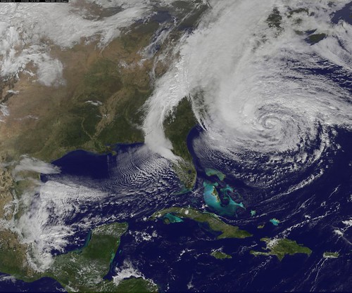
A Weather Alternative follower recently wrote asking if there were any indications of hurricanes for Maryland this September. After checking various charts and planetary alignments, I've put together some dates that may be worth watching for possible hurricane or severe weather activity along the East Coast.
Sept 7-10
During this period, we're dealing with the square of Mercury to Pluto, and the opposition of Venus to Neptune. Some of the keys charts used in long-range weather forecasting place these planets over the Virginia and North Carolina area. At this time, the Solar Eclipse of November 3, 2013 is triggered also highlighting the East Coast area again. This may be indicative of tropical activity or some kind of severe weather.
Sept 14-15
Mars triggers the Solar Eclipse of May 20, 2012 at this time. I've used this solar eclipse to forecast severe weather and hurricanes in the past. Check out this post. It was based on this chart that I forecast Hurricane Sandy five months in advance. Read about it here. Although I wouldn't expect such a devastating storm this time, since this eclipse has a history of producing severe weather and hurricanes, it's worth watching now.
Sept 20-23
There are 3 planetary alignments working together now. Venus parallels Uranus, Mars squares Neptune, and Pluto makes its direct station. A number of key charts localizes these planetary pairs over the East Coast. What makes it more interesting is that Saturn will oppose the Solar Eclipse degree of May 9, 2013. This places Neptune over the East Coast as Mars makes its square.
Tropical Cyclone Hadi
Hurricane Erick Fulfills Long-range Forecast
Tropical Storm Andrea Fulfills Long-range Forecast!
Timing the Relief for Drought-Stricken U.S. Plains
Testing Astrometeorology Part 2
Hurricane Sandy Fulfills Long-range Weather Prediction!
Testing Astrometeorology Part 1
Long-range effects of the May 20, 2012 Solar Eclipse
Long-range effects of the May 20, 2012 Solar Eclipse Part 2
Hurricane Season 2011 Forecast Results
Hurricane Risk-Management
New Weather Alternative Website
The Winters of 2011-14
Fulfilled Long-range Forecasts for Hurricane Season 2010
Introduction to the Weather Alternative
Who Created God?
Sept 7-10
During this period, we're dealing with the square of Mercury to Pluto, and the opposition of Venus to Neptune. Some of the keys charts used in long-range weather forecasting place these planets over the Virginia and North Carolina area. At this time, the Solar Eclipse of November 3, 2013 is triggered also highlighting the East Coast area again. This may be indicative of tropical activity or some kind of severe weather.
Sept 14-15
Mars triggers the Solar Eclipse of May 20, 2012 at this time. I've used this solar eclipse to forecast severe weather and hurricanes in the past. Check out this post. It was based on this chart that I forecast Hurricane Sandy five months in advance. Read about it here. Although I wouldn't expect such a devastating storm this time, since this eclipse has a history of producing severe weather and hurricanes, it's worth watching now.
Sept 20-23
There are 3 planetary alignments working together now. Venus parallels Uranus, Mars squares Neptune, and Pluto makes its direct station. A number of key charts localizes these planetary pairs over the East Coast. What makes it more interesting is that Saturn will oppose the Solar Eclipse degree of May 9, 2013. This places Neptune over the East Coast as Mars makes its square.
Tropical Cyclone Hadi
Hurricane Erick Fulfills Long-range Forecast
Tropical Storm Andrea Fulfills Long-range Forecast!
Timing the Relief for Drought-Stricken U.S. Plains
Testing Astrometeorology Part 2
Hurricane Sandy Fulfills Long-range Weather Prediction!
Testing Astrometeorology Part 1
Long-range effects of the May 20, 2012 Solar Eclipse
Long-range effects of the May 20, 2012 Solar Eclipse Part 2
Hurricane Season 2011 Forecast Results
Hurricane Risk-Management
New Weather Alternative Website
The Winters of 2011-14
Fulfilled Long-range Forecasts for Hurricane Season 2010
Introduction to the Weather Alternative
Who Created God?
Thursday, March 13, 2014
Tropical Cyclone Hadi
In December 2013, I was commissioned to prepare forecasts for eastern Australia covering the month of March 2014. I had warned the interested party that during the time between March 9-12 there were a number of indications of severe weather off the Queensland peninsula at this time. This was due to the Mercury square Saturn aspect of March 11th. But an interesting development was taking place because this aspect was falling exactly on the previous Sun square Saturn aspect that took place on February 11th exactly one month earlier. Here's the astro-locality map that tipped me off as to the time and location in March.
Topical Cyclone Hadi appeared over this area on the 10th and the 11th as shown in the weather map provided by the Australia Bureau of Meteorology. Another tropical cyclone was hitting the Queensland peninsula at the same time but that's another story.
Hurricane Erick Fulfills Long-range Forecast
Tropical Storm Andrea Fulfills Long-range Forecast!
Timing the Relief for Drought-Stricken U.S. Plains
Testing Astrometeorology Part 2
Hurricane Sandy Fulfills Long-range Weather Prediction!
Testing Astrometeorology Part 1
Long-range effects of the May 20, 2012 Solar Eclipse
Long-range effects of the May 20, 2012 Solar Eclipse Part 2
Hurricane Season 2011 Forecast Results
Hurricane Risk-Management
New Weather Alternative Website
The Winters of 2011-14
Fulfilled Long-range Forecasts for Hurricane Season 2010
Introduction to the Weather Alternative
Statistical Analysis of Astrology (see below)
Here's a paper analyzing the truth of astrology through a statistical method. The author does show that there is some positive evidence (jump to the conclusion if you're short on time).
Topical Cyclone Hadi appeared over this area on the 10th and the 11th as shown in the weather map provided by the Australia Bureau of Meteorology. Another tropical cyclone was hitting the Queensland peninsula at the same time but that's another story.
Hurricane Erick Fulfills Long-range Forecast
Tropical Storm Andrea Fulfills Long-range Forecast!
Timing the Relief for Drought-Stricken U.S. Plains
Testing Astrometeorology Part 2
Hurricane Sandy Fulfills Long-range Weather Prediction!
Testing Astrometeorology Part 1
Long-range effects of the May 20, 2012 Solar Eclipse
Long-range effects of the May 20, 2012 Solar Eclipse Part 2
Hurricane Season 2011 Forecast Results
Hurricane Risk-Management
New Weather Alternative Website
The Winters of 2011-14
Fulfilled Long-range Forecasts for Hurricane Season 2010
Introduction to the Weather Alternative
Statistical Analysis of Astrology (see below)
Here's a paper analyzing the truth of astrology through a statistical method. The author does show that there is some positive evidence (jump to the conclusion if you're short on time).
Friday, February 21, 2014
South America, China, and Australia Forecast Results
In mid-December of last year, I posted some long-range weather forecasts for Christmas and New Year's in South America and China. I included the astro-locality map below to show why I felt that the area around Bolivia and Argentina might be in for some severe weather between Dec 29, 2013 and Jan 3, 2014. I also included Ecuador and Peru. The map shows that one of the key charts used in this type of weather forecasting showed a build up of planets over the region. I foresaw a stormy period or some unusual weather.
I found that Argentina was in the grips of an intense heat wave going into this period. The following Argentine weather map showed the areas affected by the heat wave between Dec 22nd and 31st.
On the 31st severe thunderstorm warnings were issued for the north and northwestern areas of the country citing the potential for strong to severe storms generating wind gusts, hail, lightning, and periods of intense rain. On January 2nd, another warning was issued for this same area due to an advancing cold front triggering strong to severe thunderstorms.
I found mention of a low pressure area over southern Bolivia on January 1st, and severe thunderstorm warnings for most of Peru on January 2nd as shown in the map below.
The website that I used to track weather predictions I had published a few years ago for China had changed and I was unable to verify the weather there.
In another December post, I had issued a forecast for a severe weather pattern or tropical cyclone to hit the west coast of Australia between Jan 7-10, 2014. At the most, a couple of low pressure areas affect the area at this time as the map below for Jan 7th shows. By the 9th, there were Strong Wind Warnings for the west coast area of Ningaloo, Gascoyne, and Geraldton.
Hurricane Erick Fulfills Long-range Forecast
Tropical Storm Andrea Fulfills Long-range Forecast!
Timing the Relief for Drought-Stricken U.S. Plains
Testing Astrometeorology Part 2
Hurricane Sandy Fulfills Long-range Weather Prediction!
Testing Astrometeorology Part 1
Long-range effects of the May 20, 2012 Solar Eclipse
Long-range effects of the May 20, 2012 Solar Eclipse Part 2
Hurricane Season 2011 Forecast Results
Hurricane Risk-Management
New Weather Alternative Website
The Winters of 2011-14
Fulfilled Long-range Forecasts for Hurricane Season 2010
Introduction to the Weather Alternative
Does Science Prove Everything?
I found that Argentina was in the grips of an intense heat wave going into this period. The following Argentine weather map showed the areas affected by the heat wave between Dec 22nd and 31st.
On the 31st severe thunderstorm warnings were issued for the north and northwestern areas of the country citing the potential for strong to severe storms generating wind gusts, hail, lightning, and periods of intense rain. On January 2nd, another warning was issued for this same area due to an advancing cold front triggering strong to severe thunderstorms.
I found mention of a low pressure area over southern Bolivia on January 1st, and severe thunderstorm warnings for most of Peru on January 2nd as shown in the map below.
The website that I used to track weather predictions I had published a few years ago for China had changed and I was unable to verify the weather there.
In another December post, I had issued a forecast for a severe weather pattern or tropical cyclone to hit the west coast of Australia between Jan 7-10, 2014. At the most, a couple of low pressure areas affect the area at this time as the map below for Jan 7th shows. By the 9th, there were Strong Wind Warnings for the west coast area of Ningaloo, Gascoyne, and Geraldton.
Hurricane Erick Fulfills Long-range Forecast
Tropical Storm Andrea Fulfills Long-range Forecast!
Timing the Relief for Drought-Stricken U.S. Plains
Testing Astrometeorology Part 2
Hurricane Sandy Fulfills Long-range Weather Prediction!
Testing Astrometeorology Part 1
Long-range effects of the May 20, 2012 Solar Eclipse
Long-range effects of the May 20, 2012 Solar Eclipse Part 2
Hurricane Season 2011 Forecast Results
Hurricane Risk-Management
New Weather Alternative Website
The Winters of 2011-14
Fulfilled Long-range Forecasts for Hurricane Season 2010
Introduction to the Weather Alternative
Does Science Prove Everything?
Tuesday, January 21, 2014
Christmas and New Year's Day Forecast Results
These long-range weather forecasts were issued at the end of December, 2013. The Christmas Day forecast called for an energetic storm system or strong cold front to bring boisterous winds to the Northeast U.S. and New England areas.
Windy conditions did set in on Christmas Eve. The Accuweather map below shows the forecast area being affected by brisk winds and snow showers.
The main activity occurred on the 26th, a day later, when a low pressure area developed off the New England coast brining heavy and steady snow to the region. Three to six inches of snow was expected. Snow also accumulated in the Northeast causing numerous car accidents in eastern Pennsylvania. This storm was not as boisterous as expected. The Accuweather map below for the 26th shows the prevailing conditions.
The next forecast called for a low pressure system to travel from Virginia to the Canadian Maritimes and to affect the Northeast and New England with strong winds, precipitation, and hazardous weather between December 29th and January 2nd.
On the 29th, Accuweather reported that a snowstorm moving up from the south bringing drenching rain would then hit colder air and deposit heavy snow in the Northeast. The storm would then drop from 6 to 12 inches of snow over portions of New Hampshire, Maine, and New Brunswick. The combination of snow and wind brought risk of downed trees and power outages. The Accuweather map below shows the extent of the snowfall.
Then on January 2nd, Accuweather reported Blizzard to Reach From NYC to Boston Thursday Night. A major snowstorm spanned the Midwest, Appalachian Mountains, and New England affecting holiday travelers, school students, and businesses. Some areas of New England received 12 to 18 inches of snow. The storm kicked up winds creating blizzard conditions as shown in the map below. All in all, this was an accurate forecast.
January 1, 2014 Forecast: South America and China
Severe Weather Alert: Western Australia Jan. 7-10, 2014
Hurricane Erick Fulfills Long-range Forecast
Tropical Storm Andrea Fulfills Long-range Forecast!
Timing the Relief for Drought-Stricken U.S. Plains
Testing Astrometeorology Part 2
Hurricane Sandy Fulfills Long-range Weather Prediction!
Testing Astrometeorology Part 1
Long-range effects of the May 20, 2012 Solar Eclipse
Long-range effects of the May 20, 2012 Solar Eclipse Part 2
Hurricane Season 2011 Forecast Results
Hurricane Risk-Management
New Weather Alternative Website
The Winters of 2011-14
Fulfilled Long-range Forecasts for Hurricane Season 2010
Introduction to the Weather Alternative
The New Testament and Women
A quote from feminist theologian Rosemary Reuther
"It is generally assumed that Paul is the author of a Christianity of female subordination. But more recent studies have shown that the historical Paul in fact continued most of the assumptions and practices of early charismatic, inclusive Christianity. Indeed, most of the New Testament evidence that women functioned as local leaders, as well as traveling evangelists, is to be found in the Pauline letters. Paul addresses almost an equal number of women along with men (sixteen women and eighteen men) in his greetings to Church leaders in Romans 16. He mentions two women, Euodia and Syntche, as having preached the gospel "with Barnabas and me" in Philippians 4:2-3. He addresses a woman name Junia by the title of "apostle," and constantly refers to the husband and wife team, Priscilla and Aquila, as "Church leaders," usually naming Priscilla first. He also speaks of the prominent woman Phoebe by the title of both "deacon" and "prostasis" or leader, of her community.
Paul received from the early Church both a practice of thus including women in the ministries of catechesis, prophecy, local Church leadership, and traveling evangelism (the role Paul calls that of "apostle"), and also a baptismal theology of male-female equivalence in Christ as reflected in the Galatians 3:28 reference. This formula was not original with Paul; he cites it from early Christian tradition. The Galatians baptismal text expresses the early Christian vision of the new humanity in Christ. It was consciously moulded to contrast with the traditions of rabbinic piety, adapted from Hellenistic philosophy, in which the Jewish male thanks God for having been born male and not female, free and not slave, and Jew rather than Gentile. By declaring that in Christ these divisions had been overcome and all these groups made "one," the early Christian stated the essence of his or her new identity as one where the equivalence of all humans in the image of God had been restored."
Windy conditions did set in on Christmas Eve. The Accuweather map below shows the forecast area being affected by brisk winds and snow showers.
The main activity occurred on the 26th, a day later, when a low pressure area developed off the New England coast brining heavy and steady snow to the region. Three to six inches of snow was expected. Snow also accumulated in the Northeast causing numerous car accidents in eastern Pennsylvania. This storm was not as boisterous as expected. The Accuweather map below for the 26th shows the prevailing conditions.
The next forecast called for a low pressure system to travel from Virginia to the Canadian Maritimes and to affect the Northeast and New England with strong winds, precipitation, and hazardous weather between December 29th and January 2nd.
On the 29th, Accuweather reported that a snowstorm moving up from the south bringing drenching rain would then hit colder air and deposit heavy snow in the Northeast. The storm would then drop from 6 to 12 inches of snow over portions of New Hampshire, Maine, and New Brunswick. The combination of snow and wind brought risk of downed trees and power outages. The Accuweather map below shows the extent of the snowfall.
Then on January 2nd, Accuweather reported Blizzard to Reach From NYC to Boston Thursday Night. A major snowstorm spanned the Midwest, Appalachian Mountains, and New England affecting holiday travelers, school students, and businesses. Some areas of New England received 12 to 18 inches of snow. The storm kicked up winds creating blizzard conditions as shown in the map below. All in all, this was an accurate forecast.
January 1, 2014 Forecast: South America and China
Severe Weather Alert: Western Australia Jan. 7-10, 2014
Hurricane Erick Fulfills Long-range Forecast
Tropical Storm Andrea Fulfills Long-range Forecast!
Timing the Relief for Drought-Stricken U.S. Plains
Testing Astrometeorology Part 2
Hurricane Sandy Fulfills Long-range Weather Prediction!
Testing Astrometeorology Part 1
Long-range effects of the May 20, 2012 Solar Eclipse
Long-range effects of the May 20, 2012 Solar Eclipse Part 2
Hurricane Season 2011 Forecast Results
Hurricane Risk-Management
New Weather Alternative Website
The Winters of 2011-14
Fulfilled Long-range Forecasts for Hurricane Season 2010
Introduction to the Weather Alternative
The New Testament and Women
A quote from feminist theologian Rosemary Reuther
"It is generally assumed that Paul is the author of a Christianity of female subordination. But more recent studies have shown that the historical Paul in fact continued most of the assumptions and practices of early charismatic, inclusive Christianity. Indeed, most of the New Testament evidence that women functioned as local leaders, as well as traveling evangelists, is to be found in the Pauline letters. Paul addresses almost an equal number of women along with men (sixteen women and eighteen men) in his greetings to Church leaders in Romans 16. He mentions two women, Euodia and Syntche, as having preached the gospel "with Barnabas and me" in Philippians 4:2-3. He addresses a woman name Junia by the title of "apostle," and constantly refers to the husband and wife team, Priscilla and Aquila, as "Church leaders," usually naming Priscilla first. He also speaks of the prominent woman Phoebe by the title of both "deacon" and "prostasis" or leader, of her community.
Paul received from the early Church both a practice of thus including women in the ministries of catechesis, prophecy, local Church leadership, and traveling evangelism (the role Paul calls that of "apostle"), and also a baptismal theology of male-female equivalence in Christ as reflected in the Galatians 3:28 reference. This formula was not original with Paul; he cites it from early Christian tradition. The Galatians baptismal text expresses the early Christian vision of the new humanity in Christ. It was consciously moulded to contrast with the traditions of rabbinic piety, adapted from Hellenistic philosophy, in which the Jewish male thanks God for having been born male and not female, free and not slave, and Jew rather than Gentile. By declaring that in Christ these divisions had been overcome and all these groups made "one," the early Christian stated the essence of his or her new identity as one where the equivalence of all humans in the image of God had been restored."
Tuesday, December 17, 2013
January 1, 2014 Forecast: South America and China
Lately, I've been discussing certain important lunar cycles that affect weather patterns. I showed how Typhoon Haiyan was directly related to the Moon's closest monthly approach to Earth (perigee) and its maximum southern declination. (see post here)
I also ventured some forecasts based on the Moon's repeat performance of the same thing in December. Those forecasts pinpointed India and the Rocky Mountains of the United States as areas for potentially severe weather. The result was Cyclone Madi that affected India and a powerful winter storm that hit the Rockies. (see post here)
Forecast - December 29, 2013 - January 3, 2014
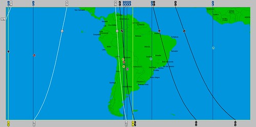
This setup will happen yet again on January 1, 2014 when the Moon will be at perigee and maximum south declination at the time of the New Moon. This type of New Moon has earned the nickname SuperMoon. At this time the Moon will also make a series of weather-disrupting aspects to Uranus, Sun, Pluto, Mars, and Mercury. Let's pinpoint where this will manifest. The astro-locality map, based on the winter solstice chart, below shows a strong concentration over Bolivia and Argentina in South America. Other charts (not shown) also include Ecuador and Peru. This most likely indicates a stormy period or unusual weather. For some of these South American countries it's their rainy season.
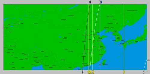
The next area to watch is China. The same planetary influences affect eastern portions of the country most likely indicating a clashing of colder Siberian air with a warmer, moist air mass from the south. The result should be a strong winter low pressure area or front that cuts through the region.
Severe Weather Alert: Western Australia Jan. 7-10, 2014
New Year's Day Weather 2014
Christmas Day Weather 2013
Hurricane Erick Fulfills Long-range Forecast
Tropical Storm Andrea Fulfills Long-range Forecast!
Timing the Relief for Drought-Stricken U.S. Plains
Testing Astrometeorology Part 2
Hurricane Sandy Fulfills Long-range Weather Prediction!
Testing Astrometeorology Part 1
Long-range effects of the May 20, 2012 Solar Eclipse
Long-range effects of the May 20, 2012 Solar Eclipse Part 2
Hurricane Season 2011 Forecast Results
Hurricane Risk-Management
New Weather Alternative Website
Overview of UK Winter 2012-13
The Winters of 2011-14
Fulfilled Long-range Forecasts for Hurricane Season 2010
Introduction to the Weather Alternative
Were They Real? The Scientific Case for Adam and Eve

I also ventured some forecasts based on the Moon's repeat performance of the same thing in December. Those forecasts pinpointed India and the Rocky Mountains of the United States as areas for potentially severe weather. The result was Cyclone Madi that affected India and a powerful winter storm that hit the Rockies. (see post here)
Forecast - December 29, 2013 - January 3, 2014
This setup will happen yet again on January 1, 2014 when the Moon will be at perigee and maximum south declination at the time of the New Moon. This type of New Moon has earned the nickname SuperMoon. At this time the Moon will also make a series of weather-disrupting aspects to Uranus, Sun, Pluto, Mars, and Mercury. Let's pinpoint where this will manifest. The astro-locality map, based on the winter solstice chart, below shows a strong concentration over Bolivia and Argentina in South America. Other charts (not shown) also include Ecuador and Peru. This most likely indicates a stormy period or unusual weather. For some of these South American countries it's their rainy season.
The next area to watch is China. The same planetary influences affect eastern portions of the country most likely indicating a clashing of colder Siberian air with a warmer, moist air mass from the south. The result should be a strong winter low pressure area or front that cuts through the region.
Severe Weather Alert: Western Australia Jan. 7-10, 2014
New Year's Day Weather 2014
Christmas Day Weather 2013
Hurricane Erick Fulfills Long-range Forecast
Tropical Storm Andrea Fulfills Long-range Forecast!
Timing the Relief for Drought-Stricken U.S. Plains
Testing Astrometeorology Part 2
Hurricane Sandy Fulfills Long-range Weather Prediction!
Testing Astrometeorology Part 1
Long-range effects of the May 20, 2012 Solar Eclipse
Long-range effects of the May 20, 2012 Solar Eclipse Part 2
Hurricane Season 2011 Forecast Results
Hurricane Risk-Management
New Weather Alternative Website
Overview of UK Winter 2012-13
The Winters of 2011-14
Fulfilled Long-range Forecasts for Hurricane Season 2010
Introduction to the Weather Alternative
Were They Real? The Scientific Case for Adam and Eve
Sunday, December 15, 2013
December 4, 2013 Forecast Results
In a recent post entitled An Observation on Typhoon Haiyan (Nov. 20), I formulated some forecasts for the period around Dec. 4, 2013. These forecasts were based on the two overlapping lunar cycles of perigee and maximum declination. On Dec. 4th, the Moon was also making important aspects to Uranus and Pluto. I had seen that this same setup in November had affected the Philippines coinciding with Typhoon Haiyan's arrival over the islands.
The first country that I thought would be affected by this setup was India, which I suspected would be hit by a cold front.
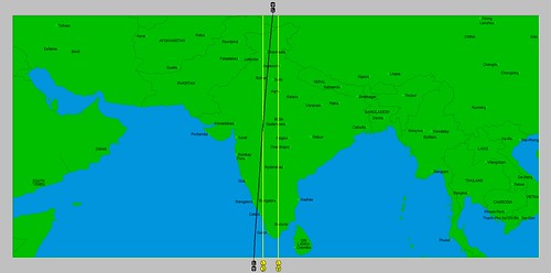
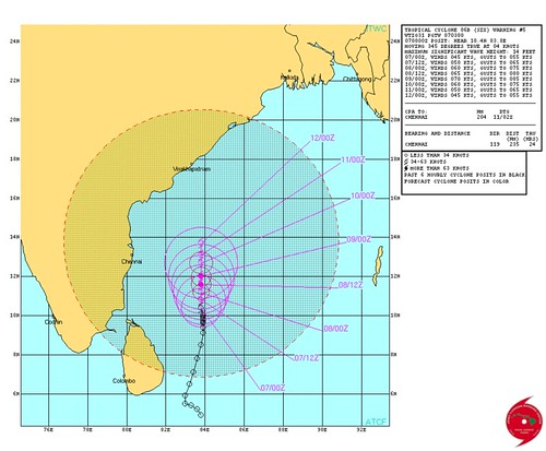
Around Dec. 4th, however, the southeastern portion of India was affected by a well-marked low pressure area that became Cyclone Madi. This was interesting since, as mentioned above, the lunar configurations of the previous month had resulted in Typhoon Haiyan. Here's the warning map issued on December 7th.
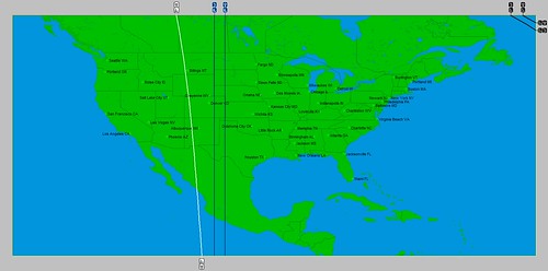
The next area of concern was the Rocky Mountain area of the United States. As shown in the astro-locality map below, the Moon, Uranus, and Pluto afflicted the area.
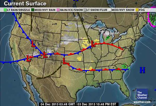
A winter storm dubbed "Cleon" by the Weather Channel dumped 20 to 30 inches of snow in some areas of the Rockies. Arctic air then plunged south across the region. The Weather Channel map below is for the evening of Dec. 3rd.
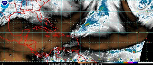
The last area centered in the western Atlantic just off the coast of Surinam.

No major system or low pressure was reported there at this time. From the water vapor imagery map of Dec. 5th below, there may have been some minor convection at most.
Severe Weather Alert: Western Australia Jan. 7-10, 2014
New Year's Day Weather 2014
Christmas Day Weather 2013
Hurricane Erick Fulfills Long-range Forecast
Tropical Storm Andrea Fulfills Long-range Forecast!
Timing the Relief for Drought-Stricken U.S. Plains
Testing Astrometeorology Part 2
Hurricane Sandy Fulfills Long-range Weather Prediction!
Testing Astrometeorology Part 1
Long-range effects of the May 20, 2012 Solar Eclipse
Long-range effects of the May 20, 2012 Solar Eclipse Part 2
Hurricane Season 2011 Forecast Results
Hurricane Risk-Management
New Weather Alternative Website
Overview of UK Winter 2012-13
The Winters of 2011-14
Fulfilled Long-range Forecasts for Hurricane Season 2010
Introduction to the Weather Alternative
The first country that I thought would be affected by this setup was India, which I suspected would be hit by a cold front.
Around Dec. 4th, however, the southeastern portion of India was affected by a well-marked low pressure area that became Cyclone Madi. This was interesting since, as mentioned above, the lunar configurations of the previous month had resulted in Typhoon Haiyan. Here's the warning map issued on December 7th.
The next area of concern was the Rocky Mountain area of the United States. As shown in the astro-locality map below, the Moon, Uranus, and Pluto afflicted the area.
A winter storm dubbed "Cleon" by the Weather Channel dumped 20 to 30 inches of snow in some areas of the Rockies. Arctic air then plunged south across the region. The Weather Channel map below is for the evening of Dec. 3rd.
The last area centered in the western Atlantic just off the coast of Surinam.
No major system or low pressure was reported there at this time. From the water vapor imagery map of Dec. 5th below, there may have been some minor convection at most.
Severe Weather Alert: Western Australia Jan. 7-10, 2014
New Year's Day Weather 2014
Christmas Day Weather 2013
Hurricane Erick Fulfills Long-range Forecast
Tropical Storm Andrea Fulfills Long-range Forecast!
Timing the Relief for Drought-Stricken U.S. Plains
Testing Astrometeorology Part 2
Hurricane Sandy Fulfills Long-range Weather Prediction!
Testing Astrometeorology Part 1
Long-range effects of the May 20, 2012 Solar Eclipse
Long-range effects of the May 20, 2012 Solar Eclipse Part 2
Hurricane Season 2011 Forecast Results
Hurricane Risk-Management
New Weather Alternative Website
Overview of UK Winter 2012-13
The Winters of 2011-14
Fulfilled Long-range Forecasts for Hurricane Season 2010
Introduction to the Weather Alternative
Monday, December 02, 2013
Severe Weather Alert: Western Australia Jan 7-10, 2014
The potential for a severe weather pattern, possibly a tropical cyclone, to hit the west coast of Australia between January 7-10, 2014 is indicated in long-range forecast models. The models are based on the method utilized by Johannes Kepler, the 17th Century astronomer and discoverer of the planetary laws of motion. Kepler's observations led him to conclude that alignments among the planets of our solar system correlated with weather events on Earth.
Based on these studies, the alignment of the planets Mercury and Venus on January 8, 2014 and that of Mars and Jupiter on January 9 indicate a severe weather pattern will develop over the west coast of Western Australia. Traditionally, Venus has been observed to impregnate the atmosphere with moisture, thus increasing temperatures and humidity. When aligned with Mercury, warm winds blow resulting in the formation of low pressure systems. The Mars-Jupiter combination results in excessive heat that can result in the sudden formation of storm systems.
Taken together, an anomalous weather pattern will develop over the west coast of Western Australia at this time and push toward the east. Increasing temperatures and humidity will likely result in a low pressure system that affects the area. Since Australia is in its cyclone season, one possible scenario is that a tropical cyclone affects the forecast area. If not an actual cyclone, severe storms are likely. Stay tuned to your local weather providers at this time for more details.
New Year's Day Weather 2014
Christmas Day Weather 2013
Hurricane Erick Fulfills Long-range Forecast
Tropical Storm Andrea Fulfills Long-range Forecast!
Timing the Relief for Drought-Stricken U.S. Plains
Testing Astrometeorology Part 2
Hurricane Sandy Fulfills Long-range Weather Prediction!
Testing Astrometeorology Part 1
Long-range effects of the May 20, 2012 Solar Eclipse
Long-range effects of the May 20, 2012 Solar Eclipse Part 2
Hurricane Season 2011 Forecast Results
Hurricane Risk-Management
New Weather Alternative Website
Overview of UK Winter 2012-13
The Winters of 2011-14
Fulfilled Long-range Forecasts for Hurricane Season 2010
Introduction to the Weather Alternative
Global Warming Skeptics Speak Out: Dr. Joseph D'Aleo (2008)
Wednesday, November 27, 2013
New Year's Day Weather 2014

A potent
winter storm gearing up around the 29th of December will afflict the
Northeast U.S., New England, and Nova Scotia through January 2nd of
the New Year. Long-range forecast models provide strong indications of a low
pressure system to form or at least pass near the Virginia coast and buffet the
northeastern sector of the country with strong winds, precipitation, and
hazardous weather conditions as it treks toward the Canadian Maritimes.
This
long-range forecast is based on the relationship observed between planetary
phenomena and atmospheric changes as expounded upon by Johannes Kepler, the
discoverer of the planetary laws of motion. A fully documented record of his
work from 1602 to 1629 appears in Kepler’s “Mysterium Cosmographicum.”
Planetary alignments
involving the Sun, Mercury, Mars, Uranus, and Pluto culminate at this time. The
above forecast is based on observations of previous weather patterns that
coincided with these same alignments. In addition, the New Moon of January 1st
will be a perigee-syzygy, commonly referred to as a SuperMoon. This describes a
New or Full Moon that takes place when the Moon is at its closest approach to
Earth. This particular SuperMoon has the extra influence of the Moon also being
at its southernmost declination indicating storms of a more intense nature.
Stay safe
and check in with your local weather news source to keep abreast of conditions
in your area at this time.
Christmas Day Weather 2013
Hurricane Erick Fulfills Long-range Forecast
Tropical Storm Andrea Fulfills Long-range Forecast!
Timing the Relief for Drought-Stricken U.S. Plains
Testing Astrometeorology Part 2
Hurricane Sandy Fulfills Long-range Weather Prediction!
Testing Astrometeorology Part 1
Long-range effects of the May 20, 2012 Solar Eclipse
Long-range effects of the May 20, 2012 Solar Eclipse Part 2
Hurricane Season 2011 Forecast Results
Hurricane Risk-Management
New Weather Alternative Website
Overview of UK Winter 2012-13
The Winters of 2011-14
Fulfilled Long-range Forecasts for Hurricane Season 2010
Introduction to the Weather Alternative
Hurricane Erick Fulfills Long-range Forecast
Tropical Storm Andrea Fulfills Long-range Forecast!
Timing the Relief for Drought-Stricken U.S. Plains
Testing Astrometeorology Part 2
Hurricane Sandy Fulfills Long-range Weather Prediction!
Testing Astrometeorology Part 1
Long-range effects of the May 20, 2012 Solar Eclipse
Long-range effects of the May 20, 2012 Solar Eclipse Part 2
Hurricane Season 2011 Forecast Results
Hurricane Risk-Management
New Weather Alternative Website
Overview of UK Winter 2012-13
The Winters of 2011-14
Fulfilled Long-range Forecasts for Hurricane Season 2010
Introduction to the Weather Alternative
Monday, November 25, 2013
Christmas Day Weather 2013

A boisterous
weather system will affect the Northeast U.S. and New England on Christmas Day
this year. The storm system will carry potentially damaging winds as an energetic
low pressure area or strong front treks through the region.
This
long-range forecast is based on the relationship observed between planetary
phenomena and atmospheric changes as expounded upon by Johannes Kepler, the
discoverer of the planetary laws of motion. A fully documented record of his
work from 1602 to 1629 appears in Kepler’s “Mysterium Cosmographicum.”
In regards
to Christmas Day, the celestial alignments taking place at this time include
the opposition of the planets Mars and Uranus as well as Mars’ activation of
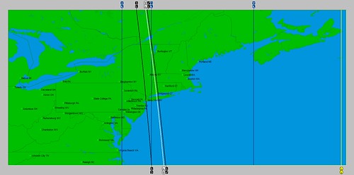
the July 1, 2011 Solar Eclipse. As seen in the astro-locality map below, a
number of planetary influences (represented by the white, blue, and black lines
on the map) congregate over the U.S. Northeast.
The last
opposition between Mars and Uranus occurred on July 18, 2012. This particular
opposition also affected the same northeastern section of the country.
Accuweather reported on this date that “vicious storms” affected Boston, NYC,
Philly, and DC. They warned of “beastly storms” packing “damaging blasts of
wind.” Hail, lightning, and blinding downpours also accompanied the storms.
So, those of
you living in this area of the country or travelling there for the holidays
stay safe and have a Merry Christmas.
An Observation on Typhoon Haiyan
Hurricane Erick Fulfills Long-range Forecast
Tropical Storm Andrea Fulfills Long-range Forecast!
Timing the Relief for Drought-Stricken U.S. Plains
Testing Astrometeorology Part 2
Hurricane Sandy Fulfills Long-range Weather Prediction!
Testing Astrometeorology Part 1
Long-range effects of the May 20, 2012 Solar Eclipse
Long-range effects of the May 20, 2012 Solar Eclipse Part 2
Hurricane Season 2011 Forecast Results
Hurricane Risk-Management
New Weather Alternative Website
Overview of UK Winter 2012-13
The Winters of 2011-14
Fulfilled Long-range Forecasts for Hurricane Season 2010
Introduction to the Weather Alternative
An Observation on Typhoon Haiyan
Hurricane Erick Fulfills Long-range Forecast
Tropical Storm Andrea Fulfills Long-range Forecast!
Timing the Relief for Drought-Stricken U.S. Plains
Testing Astrometeorology Part 2
Hurricane Sandy Fulfills Long-range Weather Prediction!
Testing Astrometeorology Part 1
Long-range effects of the May 20, 2012 Solar Eclipse
Long-range effects of the May 20, 2012 Solar Eclipse Part 2
Hurricane Season 2011 Forecast Results
Hurricane Risk-Management
New Weather Alternative Website
Overview of UK Winter 2012-13
The Winters of 2011-14
Fulfilled Long-range Forecasts for Hurricane Season 2010
Introduction to the Weather Alternative
Wednesday, November 20, 2013
An Observation on Typhoon Haiyan
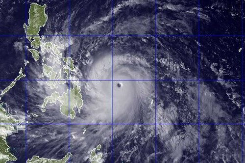
On November
8th, Typhoon Haiyan slammed into the Philippines killing over 10,000
people. Here, over the years on the pages of the Weather Alternative, I’ve made numerous accurate long-range forecasts
naming the dates and places of hurricane formations and landfalls months in
advance. The links below provide the specifics. My work is based on the work of
Johannes Kepler, who was convinced of the truth that the alignments of the
planets in our solar system affect weather patterns here on Earth.
As I
reviewed the different planetary alignments at the time of Typhoon Haiyan’s
landfall over the Philippines, I came across an interesting “key” that I think
will be instrumental in future forecasts. That key has to do with our closest satellite,
the Moon. In astro-meteorology, the Moon has long been known as an important
timing factor in long-range weather forecasting, the distributor of moisture,
and the celestial trigger that activates other planetary alignments. The Moon,
as a weather forecasting tool, has been expertly explored by long-range weather
forecaster Ken Ring of www.predictweather.com
Besides orbiting
the Earth every 27.32 days, the Moon also varies in its closeness to Earth. Its
closest approach to Earth is called perigee, and its farthest distance from the
Earth is termed apogee. This aspect of the Moon’s orbit is referred to as the
anomalistic month, which is 27.55 days in length. The Moon also moves north and
south of the equator in its orbit at the same time. At some point in the month,
the Moon will reach its highest north declination and then begin to head south.
After it reaches its southern most declination it begins to head north again
and repeat the cycle.
Each one of
these cycles is important in long-range weather forecasting. At times, these
cycles can overlap each other for a while, and when they do, the lunar influence
is even stronger than usual. This is exactly what was happening during Typhoon
Haiyan’s landfall over the Philippines. Around November 7th, the
Moon was at its closest approach to Earth (perigee) and at its
southernmost declination. In addition to this, the Moon was making a square to
Uranus and an opposition to Pluto. These two outer planets and been in exact
square to each other on November 1st so they were still very close.
The square between these two planets, according to astro-meteorology is very
disruptive to atmospheric conditions. The chart below shows that at the time
the Moon made its square to Uranus all three celestial bodies were over the
Philippines.

Let’s follow
this pattern because it repeats itself during the month of December. The Moon
will be at its southernmost declination and at its closest approach to Earth
again as it squares Uranus and conjoins Pluto on December 4th. Now,
Uranus and Pluto will not be as close to each other as they were in
November, but I think we should see some type of severe weather system
generated by this. The first astro-locality map below shows that India will be
affect. This is the post-monsoon season in India, so, since Uranus-Pluto can
signify cold air masses, there might be an outbreak of cold air from the north.
The next map
shows that this trio will also affect the Rocky Mountains of the United States.
This could result in a strong cold front and perhaps precipitation and windy
conditions.
The last map
shows the Moon, Uranus, and Pluto over the waters just north of the Guyanas of
South America. We are no longer in hurricane season at this time but perhaps
some type of low pressure area will form.
Hurricane Erick Fulfills Long-range Forecast
Tropical Storm Andrea Fulfills Long-range Forecast!
Timing the Relief for Drought-Stricken U.S. Plains
Testing Astrometeorology Part 2
Hurricane Sandy Fulfills Long-range Weather Prediction!
Testing Astrometeorology Part 1
Long-range effects of the May 20, 2012 Solar Eclipse
Long-range effects of the May 20, 2012 Solar Eclipse Part 2
Hurricane Season 2011 Forecast Results
Hurricane Risk-Management
New Weather Alternative Website
Overview of UK Winter 2012-13
The Winters of 2011-14
Fulfilled Long-range Forecasts for Hurricane Season 2010
Introduction to the Weather Alternative
Obamacare Fix

Sunday, November 03, 2013
Dangerous Weather Pattern Results
The October 1, 2013 post Dangerous Weather Pattern October 30-November 3, 2013 warning of a severe weather pattern to affect the Plains and Mississippi Valley materialized on schedule fulfilling the long-range forecast issued thirty days in advance.
Here are some of the details:
Forecast
The forecast related that the storm system would likely start over the West Coast states, transfer its energy eastward, and crank up over the Plains.
Results
The Weather Channel reported on Tuesday, October 29th that "The cold front from the Rockies winter storm charges eastward Wednesday (30th) increasing the threat of severe thunderstorms in western and central Oklahoma and central Texas."
Forecast
The forecast then mentioned that serious activity starts around October 30th when a major storm system would affect the Central Plains with severe weather warnings as far south as Texas. The severe weather system would then continue through the Mississippi Valley.
Results
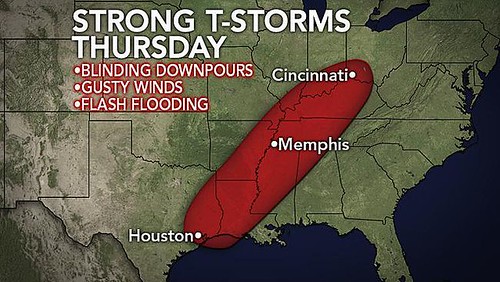
Accuweather reported that on Wednesday, October 30th, "Thunderstorms produced wind gusts over 60 mph in southwestern Oklahoma Wednesday night and extreme downpours caused flash flooding across central Texas into the early morning hours Thursday." Below is the Weather Channel map for October 30th.
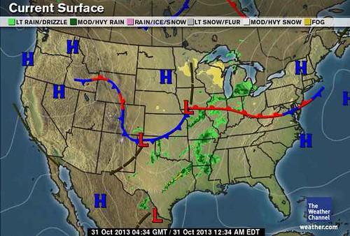
According to the Weather Channel, 1 to 3 inches of rain was expected from Missouri to Michigan with isolated amounts of 4 to 5 inches in some areas. Sustained winds of 15 to 35 mph with gusts up to 50 mph were expected over the Great Lakes. The lower Mississippi Valley was also under a severe weather threat best shown by the following Accuweather map for October 31st.
Shortly I will post some long-range weather forecasts for the U.S. Northeast winter.
Hurricane Erick Fulfills Long-range Forecast
Tropical Storm Andrea Fulfills Long-range Forecast!
Timing the Relief for Drought-Stricken U.S. Plains
Testing Astrometeorology Part 2
Hurricane Sandy Fulfills Long-range Weather Prediction!
Testing Astrometeorology Part 1
Long-range effects of the May 20, 2012 Solar Eclipse
Long-range effects of the May 20, 2012 Solar Eclipse Part 2
Hurricane Season 2011 Forecast Results
Hurricane Risk-Management
New Weather Alternative Website
Overview of UK Winter 2012-13
The Winters of 2011-14
Fulfilled Long-range Forecasts for Hurricane Season 2010
Introduction to the Weather Alternative
Here are some of the details:
Forecast
The forecast related that the storm system would likely start over the West Coast states, transfer its energy eastward, and crank up over the Plains.
Results
The Weather Channel reported on Tuesday, October 29th that "The cold front from the Rockies winter storm charges eastward Wednesday (30th) increasing the threat of severe thunderstorms in western and central Oklahoma and central Texas."
Forecast
The forecast then mentioned that serious activity starts around October 30th when a major storm system would affect the Central Plains with severe weather warnings as far south as Texas. The severe weather system would then continue through the Mississippi Valley.
Results
Accuweather reported that on Wednesday, October 30th, "Thunderstorms produced wind gusts over 60 mph in southwestern Oklahoma Wednesday night and extreme downpours caused flash flooding across central Texas into the early morning hours Thursday." Below is the Weather Channel map for October 30th.
According to the Weather Channel, 1 to 3 inches of rain was expected from Missouri to Michigan with isolated amounts of 4 to 5 inches in some areas. Sustained winds of 15 to 35 mph with gusts up to 50 mph were expected over the Great Lakes. The lower Mississippi Valley was also under a severe weather threat best shown by the following Accuweather map for October 31st.
Shortly I will post some long-range weather forecasts for the U.S. Northeast winter.
Hurricane Erick Fulfills Long-range Forecast
Tropical Storm Andrea Fulfills Long-range Forecast!
Timing the Relief for Drought-Stricken U.S. Plains
Testing Astrometeorology Part 2
Hurricane Sandy Fulfills Long-range Weather Prediction!
Testing Astrometeorology Part 1
Long-range effects of the May 20, 2012 Solar Eclipse
Long-range effects of the May 20, 2012 Solar Eclipse Part 2
Hurricane Season 2011 Forecast Results
Hurricane Risk-Management
New Weather Alternative Website
Overview of UK Winter 2012-13
The Winters of 2011-14
Fulfilled Long-range Forecasts for Hurricane Season 2010
Introduction to the Weather Alternative
Tuesday, October 01, 2013
Dangerous Weather Pattern October 30-November 3, 2013
The commencement of the fall season on September 22nd of this year set up some important planetary influences over the central U.S. These initial positions are about to be triggered during the period of October 30th through November 3rd. A simple glance at the astro-locality map for the beginning of the fall season shows five planetary lines making various crossings over the eastern Plains.
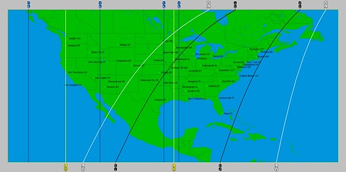
The three vertical lines from left to right represent the positions of Saturn, the Moon, and Venus. The two diagonal lines crossing them from left to right represent Pluto and Jupiter.
Serious planetary activity starts around October 30th when transit Mercury conjoins the middle of the three vertical lines or the Moon line. Mercury is at this time retrograde, which increases its storm-engendering capabilities. Then on November 1st, the Sun will conjoin this retrograde Mercury exactly on the Saturn line. When the Sun conjoins a retrograde Mercury very stormy and windy conditions are indicated--much more so when taking place on Saturn's position.
At the same time, Saturn will now move over the Venus line or the rightmost of the three vertical lines mentioned. Uranus will make a square aspect to the Pluto line, and Jupiter will make a square aspect to the Mercury line, which is the blue line running vertically through the Rocky Mountains.
Taken together we appear to have the potential for a major storm system to affect the central Plains and Mississippi Valley area at this time. This may be one of those storm systems which starts on the West Coast and transfers its energy eastward until it really cranks up over the Plains. I wouldn't be surprised to see the National Weather Service begin to issue severe weather warnings as far south as Texas and northward through the Plains. These may include winter weather warnings and high wind warnings. The Weather Channel of late has started to name winter storms. Although we're not in the winter season, they may give this storm some kind of name.
Hurricane Erick Fulfills Long-range Forecast
Tropical Storm Andrea Fulfills Long-range Forecast!
Timing the Relief for Drought-Stricken U.S. Plains
Testing Astrometeorology Part 2
Hurricane Sandy Fulfills Long-range Weather Prediction!
Testing Astrometeorology Part 1
Long-range effects of the May 20, 2012 Solar Eclipse
Long-range effects of the May 20, 2012 Solar Eclipse Part 2
Hurricane Season 2011 Forecast Results
Hurricane Risk-Management
New Weather Alternative Website
Overview of UK Winter 2012-13
The Winters of 2011-14
Fulfilled Long-range Forecasts for Hurricane Season 2010
Introduction to the Weather Alternative
The three vertical lines from left to right represent the positions of Saturn, the Moon, and Venus. The two diagonal lines crossing them from left to right represent Pluto and Jupiter.
Serious planetary activity starts around October 30th when transit Mercury conjoins the middle of the three vertical lines or the Moon line. Mercury is at this time retrograde, which increases its storm-engendering capabilities. Then on November 1st, the Sun will conjoin this retrograde Mercury exactly on the Saturn line. When the Sun conjoins a retrograde Mercury very stormy and windy conditions are indicated--much more so when taking place on Saturn's position.
At the same time, Saturn will now move over the Venus line or the rightmost of the three vertical lines mentioned. Uranus will make a square aspect to the Pluto line, and Jupiter will make a square aspect to the Mercury line, which is the blue line running vertically through the Rocky Mountains.
Taken together we appear to have the potential for a major storm system to affect the central Plains and Mississippi Valley area at this time. This may be one of those storm systems which starts on the West Coast and transfers its energy eastward until it really cranks up over the Plains. I wouldn't be surprised to see the National Weather Service begin to issue severe weather warnings as far south as Texas and northward through the Plains. These may include winter weather warnings and high wind warnings. The Weather Channel of late has started to name winter storms. Although we're not in the winter season, they may give this storm some kind of name.
Hurricane Erick Fulfills Long-range Forecast
Tropical Storm Andrea Fulfills Long-range Forecast!
Timing the Relief for Drought-Stricken U.S. Plains
Testing Astrometeorology Part 2
Hurricane Sandy Fulfills Long-range Weather Prediction!
Testing Astrometeorology Part 1
Long-range effects of the May 20, 2012 Solar Eclipse
Long-range effects of the May 20, 2012 Solar Eclipse Part 2
Hurricane Season 2011 Forecast Results
Hurricane Risk-Management
New Weather Alternative Website
Overview of UK Winter 2012-13
The Winters of 2011-14
Fulfilled Long-range Forecasts for Hurricane Season 2010
Introduction to the Weather Alternative
Sunday, September 22, 2013
Potential Hurricane Strike Results
In my August 30, 2013 post, I mentioned some interesting planetary alignments that I thought could results in a tropical system forming in the western Atlantic and then traveling northward to the Nova Scotia area of Canada. My time frame was between September 19-22. Read the forecast here.
In the forecast, I mentioned that the area around 66 west longitude and 33 north latitude would come to life at this time. This is the area in and around Bermuda, which lies at 64 west and 32 north. On Sept. 20th, Accuweather published the following map showing a low pressure system developing over this very area.

My forecast then called for the system to travel northward and affect Nova Scotia. On the 21st, Accuweather then reported that this system will stream some heavy rain from Nova Scotia to Newfoundland on Monday and Tuesday the 23rd and 24th.
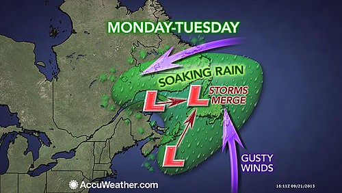
My forecast window was from Sept 19-22, so the rain will actually arrive just a tad late. But, not a bad forecast. Although it's not a hurricane, it is bringing tropical moisture to the areas I pinpointed about 3 weeks beforehand.
Hurricane Erick Fulfills Long-range Forecast
Tropical Storm Andrea Fulfills Long-range Forecast!
Timing the Relief for Drought-Stricken U.S. Plains
Testing Astrometeorology Part 2
Hurricane Sandy Fulfills Long-range Weather Prediction!
Testing Astrometeorology Part 1
Long-range effects of the May 20, 2012 Solar Eclipse
Long-range effects of the May 20, 2012 Solar Eclipse Part 2
Hurricane Season 2011 Forecast Results
Hurricane Risk-Management
New Weather Alternative Website
Overview of UK Winter 2012-13
The Winters of 2011-14
Fulfilled Long-range Forecasts for Hurricane Season 2010
Introduction to the Weather Alternative
Abortion Clinics Closing at Record Rate
Abby Johnson From Planned Parenthood to Pro-Life Advocate
In the forecast, I mentioned that the area around 66 west longitude and 33 north latitude would come to life at this time. This is the area in and around Bermuda, which lies at 64 west and 32 north. On Sept. 20th, Accuweather published the following map showing a low pressure system developing over this very area.
My forecast then called for the system to travel northward and affect Nova Scotia. On the 21st, Accuweather then reported that this system will stream some heavy rain from Nova Scotia to Newfoundland on Monday and Tuesday the 23rd and 24th.
My forecast window was from Sept 19-22, so the rain will actually arrive just a tad late. But, not a bad forecast. Although it's not a hurricane, it is bringing tropical moisture to the areas I pinpointed about 3 weeks beforehand.
Hurricane Erick Fulfills Long-range Forecast
Tropical Storm Andrea Fulfills Long-range Forecast!
Timing the Relief for Drought-Stricken U.S. Plains
Testing Astrometeorology Part 2
Hurricane Sandy Fulfills Long-range Weather Prediction!
Testing Astrometeorology Part 1
Long-range effects of the May 20, 2012 Solar Eclipse
Long-range effects of the May 20, 2012 Solar Eclipse Part 2
Hurricane Season 2011 Forecast Results
Hurricane Risk-Management
New Weather Alternative Website
Overview of UK Winter 2012-13
The Winters of 2011-14
Fulfilled Long-range Forecasts for Hurricane Season 2010
Introduction to the Weather Alternative
Abortion Clinics Closing at Record Rate
Abby Johnson From Planned Parenthood to Pro-Life Advocate
Subscribe to:
Posts (Atom)