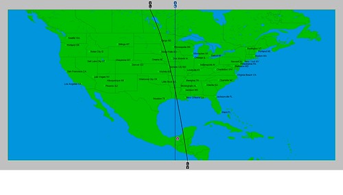
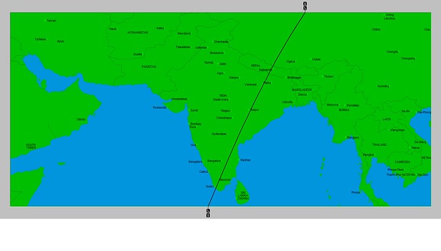
In my June 2015 article in Dell Horoscope, I mentioned that there was a chance that a low pressure system could manifest over the Louisiana area around June 21st due to the placements of Mercury and Neptune in the key summer season chart. Here's a visual representation of how those two planets affect the area.
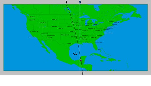
This crossing that we see over Louisiana has the potential to be activated later on in the season, and different forecasts will come up over the next months that will focus on this. But in the article, I thought that around June 21st we might see some low pressure activity since Mercury would square Neptune on the 23rd. In astro-meteorology, squares are disruptive influences on weather patterns. In the next map below, we see their positions on the 23rd, when they perfect their square. The crossing moves southward into the Gulf of Mexico.
You'll notice I put a little circle to the left of the crossing. That's because on the 25th a tropical wave was moving through that corner of the Gulf and positioned at 94 west longitude and 24 north latitude where the circle is. Prior to this, the tropical wave was over the Yucatan on the 24th.
The first forecast of my article Celestial Storm Warnings that appears in the June 2015 edition of Dell Horoscope is for the period between June 9-12. The forecast was based on the astro-locality map below where we see two planetary lines (those of Mercury and Neptune) crossing south of New England and east of Virginia around 70 west longitude and 36 north latitude.
Although the article deals with hurricane forecasts, I mentioned it might be too early on in the season at this particular location for a tropical system to form. Therefore, I said there might be a non-tropical low pressure area that forms there or a front.
The National Weather Service forecast map for June 8th shows a stationary front forming over 70 west longitude and about 33 north latitude, as shown in the next map.
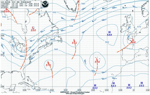
Then on the 9th, the NWS map shows a low pressure area forming around 35 north latitude but a bit farther east at around 64 west longitude. It's shown on the next map and labeled with an "L" and the number 576.
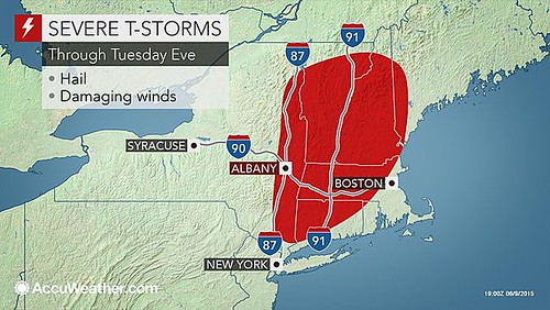
It's interesting to note that the planetary lines in the astro-locality map extend northward through New England. On the 9th, AccuWeather.com posted the following map showing severe thunderstorms with hail and damaging winds for the New England area.
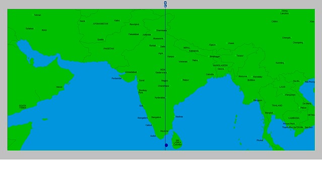
The May 30th post, India Heat Wave, discussed one of the planetary influences at work over the country that, from an astro-meteorological standpoint, indicated the heat wave. I also ventured to say that the Full Moon chart of June 2nd would set up a different planetary influence that would be an indication of a pattern change to wetter conditions. This was due to Venus occupying the eastern coast of India. In astro-meteorology, Venus in the sign Cancer, is indicative of increasing moisture and showers. The map below shows the position of Venus at the time of the Full Moon.
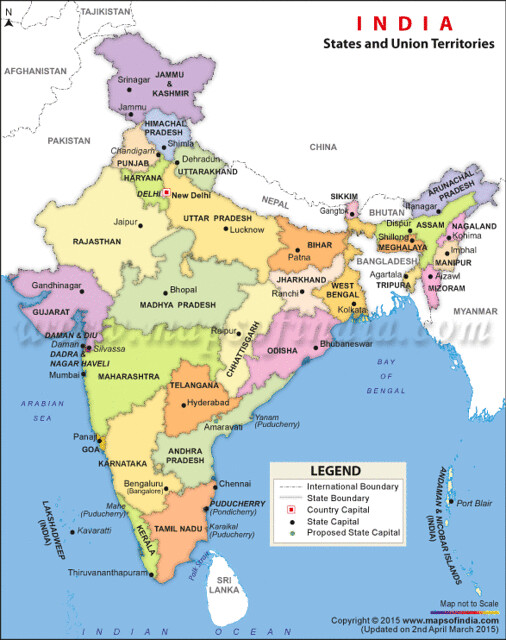
Following are a few news reports of monsoon activity over the Indian subcontinent in recent days confirming an influx of moisture over the regions that Venus occupied at the Full Moon. I've included a political map of India in order to recognize more easily the states affected by the monsoon rains.
On June 5th, the India Meteorological Department stated that "Monsoon Hits Kerala." From the political map, we see that Kerala is located on the southwestern tip of the subcontinent. The astro-locality map shows the Venus line passing over that area. In the same post, the IMD stated that parts of Tamil Nadu and Andhra Pradesh could expect the advance of the monsoon in the next 48 hours. These areas fall under the Venus line in the astro-locality map.
The news story on June 6th read "Rains lash Andhra, Telangana; conditions conducive for monsoon." We'll note that Telangana is also under the Venus line. The article declared that these pre-monsoon showers brought down temperatures to the delight of the inhabitants of these areas.
Today's news report for June 9th indicated that a cyclonic circulation is now present over the coastal areas of Andhra Pradesh bringing good rainfall to the area. The report also mentions that the monsoon will remain active over Northeast India, which we can see from the astro-locality map, is under the influence of the Venus line.
India has been suffering a heat wave since around May 21st that has claimed, up until now, about 1,700 lives. Here are a couple of observations on the astro-meteorological causes of the heat wave.
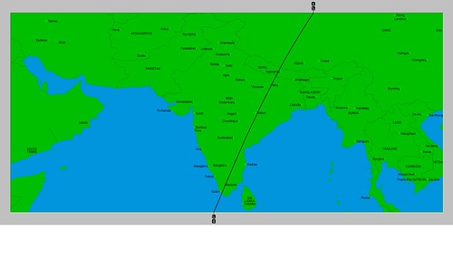
On May 18th, the New Moon took place at 26 degrees Taurus. This placed the planet Uranus over 78 east longitude through central India as seen in the astro-locality map below. In astro-meteorology Uranus induces the highest barometric pressure. At this time, Uranus is transiting the sign Aries. Although Uranus is generally known to decrease temperatures, Aries is equated with hot and dry temperatures and conditions. So combining the high pressure of Uranus with Aries characteristics, we have the makings of a heat wave.
The next lunar phase is the Full Moon of June 2nd. This chart, as seen below, will place the planet Venus along the eastern coast of India. Venus in astro-meteorology is indicative of downfall in excess of the normal period. Venus is transiting through the sign Cancer which is a wet sign. This would be an indication that the weather pattern changes to usher in moisture over those portions of India and begin to combat the reigning heat wave. Let's hope so.
You can find my latest hurricane predictions for the 2015 season in the June edition of Dell Horoscope. I cover what I feel are important planetary alignments that could result in tropical storm or hurricane formation between June and November of this year. Check it out. I'll be posting the results here on the Weather Alternative blog.
For more information about long-range weather forecasting and forecast accuracy, see the links below.
Here are the results of The Weather Alternative forecasts for March 2015. The first forecast period for March 11-14 zeroed in on the U.S. East Coast. I expected similar weather to that of November 17, 2014 when a strong winter storm brought a low pressure area and frigid winds to the Northeast and New England as well as low pressure systems from the Carolinas northward.
Here are some of the weather headlines from that period. On the 13th, AccuWeather reported, "Northeast Storm to Raise Flooding Risk, Bring Wintry Travel." On the 14th, the National Weather Service warned, "Heavy Snow to Impact Northern New England."
The flooding mentioned by AccuWeather was to affect the central Appalachians to the mid-Atlantic and create slippery travel and power outages in New England. The heavy snow to impact northern New England was due to a redeveloping low over the Gulf of Maine.
The AccuWeather map below shows the system on the 14th with even some flooding for Long Island and southern New England. It was this storm that added two more inches of snow to the Boston total for the season making it snowiest season on record with a total of 108.6 inches.
The next forecast was for the March 16-19 period. I thought windy conditions would affect California and stormy weather would hit the Pacific Northwest.
The National Weather Service reported on the 16th that unsettled weather would affect the Pacific Northwest. Then for the 18th they reported that a closed upper-level low will develop over Southern California and Northwestern Mexico a chance of thunderstorms resulting in brief heavy rains and small hail. A similar setup was reported for central California but no weather systems of major importance.
For more information about long-range weather forecasting and forecast accuracy, see the links below.
There are some planetary alignments in March that have the potential to result in some interesting weather patterns. I'd like to comment on two periods in March. One affects the East Coast U.S. and the other the West Coast.
March 11-14, 2015
This period features the conjunction of Mars and Uranus, and the square of Mars and Pluto. These aspects by Mars serve to trigger the Uranus-Pluto square beforehand which is exact on the 16th. What makes this even more important is that the conjunction takes place on the degree of the previous lunar eclipse of October 8, 2014. Here is the astro-locality map for that eclipse.
Notice the lines that fall over the New England area. This is where the Sun and Moon were rising and setting at the time of the eclipse. It is this point that will be triggered by the Mars-Uranus-Pluto combination.
The last time Mars activated this eclipse degree was on November 15, 2014. By the 17th of November, Winter Storm Bozeman (as nicknamed by the Weather Channel) was over New England. The AccuWeather map below shows the weather that affected the area.
The following Weather Channel map presents another view of the November 17th storm. We see multiple low pressure system running along the East Coast much like the lines in our astro-locality map has many planetary lines affecting the East Coast from the Carolinas northward.
We may expect similar weather between March 11th and 14th this year. The Mars-Uranus combination usually brings energetic weather systems and gusty winds. Mars-Pluto is also very disruptive to weather conditions. So we may see a strong front or low pressure system(s) that affects the Carolinas northward through New England with windy and stormy conditions.
March 16-19, 2015
Saturn will make its retrograde station on the 14th and then receive a square from Mercury on the 16th. The astro-locality map for the winter season places Saturn over California as can be seen by the black line in the map below.
The other yellow line represents the position of Jupiter, which also plays an important role in relation to the developing weather pattern there. This is because Jupiter will oppose the planetary position held by Mars at the beginning of the winter season.
So, what kind of weather can we expect? Well, last year Saturn was also placed over the West Coast in the seasonal winter map. At the time Saturn made its retrograde station last year on March 2nd, the days following showed energetic storm systems that entered the Pacific Northwest even affecting northern and central California at times.
When Mercury squared Saturn last year, there were strong and gusty winds in Nevada, New Mexico and southern California but not much moisture. As for the Mars-Jupiter combination, it is a storm-breeding aspect. Taken together we can probably count on a wind event for the California area with perhaps stormy conditions potentially affecting the Pacific Northwest.
For more information about long-range weather forecasting and forecast accuracy, see the links below.
My forecast for January 28-31, 2015 called for wet and windy West Coast weather for Washington, Oregon, and California. This was based on certain planetary alignments such as the Sun's conjunction to Mercury which excites wind velocities, and Venus' alignment with Saturn, which is known for heavy downfall. Both of these congregated over the West Coast as shown in the astro-locality map below.
My idea was that these two alignments would work together, but in actuality the one seemed to block the other. The wet weather was experienced over the Southwestern states over Arizona, New Mexico, and the Four Corners region. A "closed low" over southern California and strong low-level winds brought an abundance of Pacific moisture onshore which fueled moderate to heavy precipitation there. According to the National Weather Service, a beneficial steady soaking light to moderate rain affected the mountains of southern California. The following Weather Channel map shows the low over the above mentioned area.
As far as windy conditions go, there were various reports of breezy to windy conditions over northern California, gusty northeast winds over Nevada, and some breezy conditions over southern California. The actual weather experienced was very different than what the forecast called for.
For more information about long-range weather forecasting, more forecasts, and forecast accuracy, see the links below.
In a long-range weather forecast posted last December 13th, I gave my
take on the noteworthy weather that I thought would affect the East and West
Coasts between the 19th and 25th of January. Let’s see
what happened.
East Coast
My forecast
relied heavily on the October 23rd 2014 solar eclipse which was now
being activated and previously had produced, according to astro-meteorology, a
Nor’easter over the U.S. Northeast and New England. One scenario I suggested
was a low pressure area over the Carolinas that would then strengthen and move northward to the Northeast and New England with potential to develop into a Nor’easter. On the 23rd and 24th as can be seen in the Accuweather map below, a low developed and passed over the Carolinas becoming a major winter storm that affected the Northeast and New England. Accuweather’s headline was, “Major
Snowstorm May Hit I-95 Corridor From DC to NYC, Boston.”
Now, what’s
coming on the heels of that is another major blizzard that starts to affect the
Northeast and New England just a day after my forecast period ended on the 25th.
That is to say that on the 26th, a blizzard will, in the words of
Accuweather, shut down Boston and the New York City area. The next Accuweather map
shows the extent of the storm.
West Coast
Due to
certain planetary aspects I envisioned a storm system over the area, especially
Southern California. Now, I thought that this storm system entailed moisture,
which is desperately needed there, however, there was no precipitation. Because of Mercury’s retrograde station,
which is a wind-breeding influence, my forecast also called for windy conditions as far south as Southern California. The windy conditions over Southern
California were what did materialize.
Starting on
the 21st and continuing through the 25th, the National
Weather Service began to post wind warnings for Southern California. Their
posts warned of locally gusty winds, and strong and damaging winds, or what are
known as Santa Ana winds. Fox news reported more than 54,000 customers who were
affected by power outages in the Los Angeles area due to fierce Santa Ana winds
that toppled trees and knocked down power poles across the area. The area was
also besieged by dangerous rip currents and high surf due to a storm system in
the Pacific Ocean. Below is a picture of high surf crashing over the Southern
California coast on the 24th.
For more information about long-range weather forecasting, more forecasts, and forecast accuracy, see the links below.
Links to Other Long-range Weather Forecasts and Forecast Results
West Coast inhabitants should prepare for strong winds and heavy rain between the 28th and 31st of January. According to the long-range weather forecast method employed by Johannes Kepler, the 17th century mathematician, astronomer, and astrologer, the planetary alignments at the end of January spell weather woes for Washington, Oregon, and California.
The forecast is based on alignments between the Sun and Mercury, as well as Venus and Saturn. The conjunction of the Sun and Mercury has been observed by astro-meteorologists to excite wind velocities and cause atmospheric turbulence when these occupy key positions in astro-locality weather maps. At the same time, Venus will form a quadrature to Saturn. Long-range weather forecasters have found this alignment to coincide with low pressure systems and heavy downfall. The astro-locality map below, shows how these members of our solar system congregate over the West Coast states and form a "crossing" over northern California.
For more information about long-range weather forecasting, more forecasts, and forecast accuracy, see the links below.
Links to Other Long-range Weather Forecasts and Forecast Results
The last forecast of the December 2014 forecasts focused on December 29th and the following few days. I mentioned that two solar eclipses were being activated by the transits of Mars and Jupiter. Consequently, we were to look for a weather reaction in the form of a front or low pressure system over the Great Lakes and Northeast. I also mentioned an invasion of cold air over the Rockies.
The first AccuWeather map below from December 27th shows blustery conditions setting in over the Great Lakes area and headed eastward on New Year's Eve.
The invasion of cold air mentioned in the forecast for the Rockies is shown in the next AccuWeather map. This map covers the period between December 29th and 31st. Notice that the core of the cold is over the Rockies.
Links to Other Long-range Weather Forecasts and Forecast Results
Here are some results of the December 2014 Weather Predictions that I posted on December 5th. In this post, I followed a number of solar eclipses that were being triggered during December and forecast the weather conditions that, according to my experience with astro-meteorology, would result.
December 16
The first forecast period was centered on December 16th. The area to be affected was the U.S. eastern Plains where stormy conditions were to ensue. The astro-locality map of the April 29, 2014 solar eclipse on which I based the forecast is repeated below.
Compare the crossing of planetary lines over the U.S. eastern Plains with the low pressure area in Weather Channel map for December 15th below.
The National Weather Service in part reported, "...Swath of accumulating snows expected with a wrapped up storm system tracking through the central U.S...Moisture being pulled from
the Gulf of Mexico will fuel moderate to heavy rains...with embedded
thunderstorms..."
December 19
The next forecast discussed the solar eclipse of November 3, 2013. Here I considered 4 areas that would be affected by severe weather: the eastern Plains, the Rockies/Plains boundary, the Pacific Northwest and northern California, and the Georgia/Alabama/Tennessee area. Let's look at each one.
Eastern Plains
The forecast called for severe weather during the period from the 19th and into the next few days. A large storm system, according to the National Weather Service, is set to produce precipitation across the Iowa, Missouri, and Arkansas on the 22nd.
Rockies-Plains
The boundary between the Rockies and Plains is having a bit more of a weather reaction. The Weather Channel map below for the 19th shows a stationary front forming along the length of the area. The front is causing patchy freezing fog over parts of Colorado, Kansas, Nebraska, and the Texas and Oklahoma panhandles all the way south to the Texas-New Mexico state lines. Fog is also a problem along the front in North Dakota. Gusty winds and snow are expected in southeastern Montana on the 20th. Gusty winds and heavy snow will also affect southeastern Wyoming and reach down to Colorado due to a low driving southeast into the Plains.
Pacific Northwest and Northern California
The above map also shows a cold front entering the Pacific Northwest and northern California. In the words of Accuweather on December 18th: Northwest Storm to Unleash Heavy Rain, Fierce Winds.
Georgia/Alabama/Tennessee A low pressure area and rain are forecast to move into this area and produce rain over Georgia and Alabama. As can be seen from map below, rain is affecting this very area.
Links to Other Long-range Weather Forecasts and Forecast Results
The seven-day period from January 19-25 has some interesting planetary alignments that seem to promise noteworthy weather on both the East and West coasts of the United States. The line up is as follows: Venus opposition Jupiter, and Mars conjunct Neptune on the 19th, Mars parallel Neptune on the 20th, Mercury's retrograde station on the 21st, and a Mercury-Venus parallel, and Sun-Saturn parallel on the 25th.
West Coast
When taken together, the aspects on the 19th and 20th increase the availability of warm, moist air over the West Coast states. Mercury's retrograde station, known for its tendency to bring cold fronts and windy conditions, then kicks in. Key charts place this influence over Southern California. As we progress toward the end of the forecast period, the final planetary combinations provide a clash between warm, moist are from the Mercury-Venus combination, and cold, damp air as represented by the Sun and Saturn. So, a storm system bringing windy conditions seems to be indicated over the West Coast states as far as south as Southern California.
East Coast
The New Moon chart of January 20th, places the aforementioned Mercury and Saturn over the East Coast especially over North Carolina. The New Moon itself will trigger the solar eclipse of October 23, 2014, which set up a configuration of planets over the Northeast United States that spells storm conditions. One scenario is that a strong cold front penetrates the eastern portion of the country and produces a low pressure area over the Carolinas that then moves northward to the Northeast and New England perhaps with Nor'easter potential. Speaking of Nor'easters, I just checked the weather records for October 23, 2014 when the solar eclipse set up the initial configuration I mentioned above. Guess what? A Nor'easter hit the area. Here's the Weather Channel map below.
Their headlines read, "Nor'easter in the Northeast, soaking in the Northwest." At that time soaking rains covered the Northeast and New England with northeast winds from 15 to 35 mph. The scenario for January 19-25 may be similar.
Links to Other Long-range Weather Forecasts and Forecast Results
This month there are a number of solar eclipses that will be spurred to action by transiting planets. When this happens there is a weather reaction over the areas that had the Sun and Moon in key positions at the time of the eclipse. Some of these weather reactions will be more important than others depending on other factors at work at the time of the eclipse or at the time the eclipse is triggered. Here are a few of the next triggers.
By the way, Super Typhoon Hagupit, that as we speak is threatening the Philippines, can be traced back to both the previous lunar and solar eclipses of last October. The weather patterns I'll be mentioning here, however, will not bring such severe weather.
December 16, 2014
The solar eclipse of April 29, 2014, is triggered by Mars. So, in the few days following the 16th, the area shown in the astro-locality map below should experience some stormy conditions. This is basically the eastern Plains.
December 19, 2014
Just a few days afterward, Mars will activate the solar eclipse of November 3, 2013. As can be appreciated from the map below, the same area of the country is affected. but due to other planetary alignments at this time, there's more to talk about.
From the 19th and into the next few days, besides expecting storms over the eastern Plains area, we can also expect severe weather to develop over the Front Range area farther (thanks, Gary) west where the Rockies meets the Plains. Other indicators point to the area in and around the Texas Panhandle. Even farther east, over the Georgia/Alabama/Tennessee area there are indications of severe weather developing at this time. And based on the same eclipse, there are indications of a front or low pressure system pushing into the Pacific Northwest and northern California and this time bringing precipitation.
December 29, 2014
At this time, two eclipses are triggered: the May 2013 solar eclipse by Mars, and the November 2012 eclipse by Jupiter. The first one affects the area from the Deep South into the East Central States and eastern Great Lakes, while the other one affects the eastern Great Lakes, Mid-Atlantic, and Northeast. At this time and in the days following, we can expect a front or low pressure area to develop over the eastern portions of the country and push over the Great Lakes as it transits from there through the Northeast. Due to other factors, the Rockies should see an invasion of cold air now which may trigger precipitation.
Links to Other Long-range Weather Forecasts and Forecast Results
The recent Thanksgiving Nor'easter was a close fulfillment of the long-range forecast posted at the end of October. The forecast entitled November 22-25, 2014 East Coast Forecast told how November's New Moon was going to trigger the May 20, 2012 Solar Eclipse. As mentioned in that post, this eclipse meant the possibility of severe weather for the U.S. East Coast as shown in the astro-locality map below.
In the past, this eclipse brought hurricane activity to the East Coast and sometimes heavy rain over the Carolinas as seen in this September 2014 post. That's what happened again around the 23rd and 24th of this month. The doppler radar for Nov. 23rd shows severe thunderstorms over that very area.
The forecast also mentioned that another possibility was that a front, running the length of the East Coast, would generate storms as it pushed eastward. The next Weather Channel map for the 24th shows the front approaching the East Coast.
I also mentioned that we should watch the East Coast area roughly between November 22-25. Well, on the 26th and Thanksgiving Day, a low pressure formed and traveled the East Coast from the Carolinas to New England and the Canadian Maritimes where, as a nor'easter, it brought rain and snow and caused power outages. See the Accuweather map below.
Links to Other Long-range Weather Forecasts and Forecast Results
I posted a forecast entitled West Coast Weather: November 15-21, 2014 at the end of October. Due to certain planetary alignments as seen in the Last Quarter Moon chart of November 14th, I concluded that "The general idea is that a low pressure system or strong front will begin to affect the West Coast states during this time with the potential for heavy rainfall. This could drag on from a few days to a week it seems."
On November 18th, AccuWeather began to post that the first wave of a wet weather pattern would begin to affect the Pacific Northwest starting the next day. Then on the 19th, the National Weather Service warned that heavy rain was possible over parts of the Pacific Northwest Coast. They also warned of rain over Northern/Central California on the 19th as well as snow over the higher elevations.
Heavy rain, wind, freezing rain, sleet, and snow advisories were posted for Oregon on the 19th. Washington saw winter weather and wind advisories on the 20th. California and Nevada also had wind advisories posted on the 21st due to the storm system.
Here's a shot of the National Weather Service Radar for November 21st.
Links to Other Long-range Weather Forecasts and Forecast Results
At the end of September and beginning of October, I posted some long-range weather forecasts regarding weather systems that would affect the East and West coasts of the United States.
East Coast
The first period was that of November 8-13. One of the main charts I was looking at showed a planetary crossing over the Bahamas as shown below.
I mentioned the possibilities of a tropical system forming over the Bahamas and then affecting the Carolinas and East Coast, or just storms affecting the Carolinas and the East Coast.
Results
At this time a low pressure system developed over the area where the planetary lines cross in the above map. The next two weather maps for Nov 8 and 10 show this.
The Weather Channel reported on the 10th that rain, showers and some thunderstorms were possible in eastern North Carolina from an ocean storm in the western Atlantic. Then on the 12th they reported that an arctic front arrived affecting Virginia through New England with rain and snow.
West Coast
The next forecast was based heavily on the following astro-locality map that placed planetary crossings over the West Coast as shown below.
I called for a significant storm system to affect California and the surrounding area between November 11-14.
Results
By November 10th, conventional forecasters began to warn of wintry weather that would affect the Pacific Northwest and northern California starting on the 12th as shown in the Accuweather map below.
Accuweather reported that a blast of arctic air would set the stage for a winter storm to threaten the Northwest. Gusty winds and January-like snow would accompany the storm, which they commented was a highly unusual snow and ice storm for so early in the season. I did expect it to hit further south. It was clearly detectable, however, way in advance by using the astro-meteorological forecast method.
The planet Neptune in astro-meteorology is considered the pluvial planet par excellence. Under Neptune's signature the temperature rises and humidity increases. When Neptune occupies important positions in key charts, such positions portend downfall in excess of the seasonal average. For these reasons, it is worthwhile to turn our attention to the abovementioned period. Neptune, at this time, achieves its direct station meaning that from our position on Earth, Neptune appears to move forward in the heavens after over 5 months of retrograde motion.
One of the areas that will be affected by this change of motion and by other planetary alignments that take place shortly thereafter is the West Coast of the United States. As can be seen from the astro-locality map below a number of planets (Sun, Venus, Saturn, and Neptune) are in key positions over this portion of the country at the time of the Last Quarter Moon of November 14th.
Here's the way the timing takes place: On the 15th, the Moon will oppose Neptune (the vertical line in the above map). Then on the 16th, Neptune commences its direct motion. On the 18th the Sun and Saturn (the upper and middle white lines) form a conjunction. On the 19th, Venus (the lower white line) will align with Pluto (not shown).
The general idea is that a low pressure system or strong front will begin to affect the West Coast states during this time with the potential for heavy rainfall. This could drag on from a few days to a week it seems.
The New Moon of November 22, 2014, falls in opposition to the Solar Eclipse degree of May 20, 2012. This will serve to activate the eclipse and the positions that the planets held at that time. These eclipse charts are valuable for long-range weather forecasters. So let’s try and determine what type of weather pattern will ensue at this time. The map below shows where the planets were rising, setting, culminating, and anti-culminating at the time for the eclipse.
We can see a
number of planets congregated along the U.S. East Coast. This is where we
should focus our attention roughly between November 22nd and 25th.
In addition to this initial triggering of the eclipse, other planets will
activate a couple of the original planets that run the length of the East Coast
from Florida to New England. There are a few things we might expect from this
setup. We may see a front that runs along the East Coast and generates storms
as it pushes eastward. In the past the triggering of this eclipse has coincided
with tropical systems along the U.S. East Coast. That is a possibility,
although not a very likely one. We’ve also seen, in other instances, heavy rain due to tropical moisture even though there was no organized tropical system.