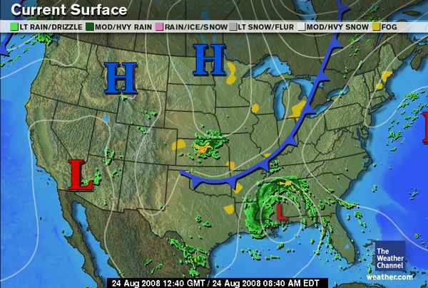
 Former Tropical Storm Fay is now over the Gulf Coast area fulfilling The Weather Alternative's long-range forecast for August 23-25, which read:
Mars is now transiting across the East Central area at 86 west longitude. On the 26th, Mercury is contra parallel Mars. Heat increases and may result in storms and windy conditions.
86 west longitude centers around the western Florida Panhandle and Alabama. Accuweather reported today that "Tropical Rainstorm Fay was located about 60 miles north of Mobile, Ala., at 4:00 a.m. CDT. The storm continues its slow track moving west-northwest near 8 mph, and maximum-sustained winds are only near 30 mph. "
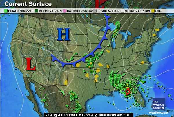 Another recent long-range forecast for August 20-24 stated This period starts with a warm and moist air mass pushing up over the Plains due to Mercury's conjunction with Venus. As these planets pass to the opposition of Uranus a cold air mass clashes with it resulting in storms throughout the Plains.
 The Weather Channel map at left shows a front and storms pushing through the area. During the period severe thunderstorms were reported through North Dakota, Minnesota, Wisconsin, Iowa, Illinois, and 1 to 2 inches of rain in Missouri.
 Going back a bit further, there were some Weather Alternative forecasts made for the period of Aug 15-17 and Aug 17-19 that need to be assessed.
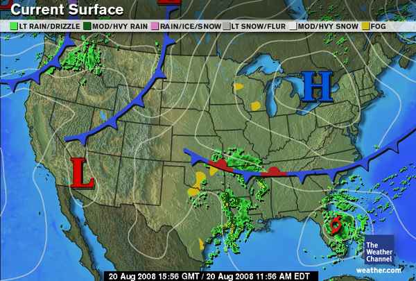
First August 17-19: The Weather Channel map at left for August 20th shows a front and storms entering the Pacific Northwest. This fulfills what was mentioned in the "Solar Eclipse Time" post about a low pressure system off the U.S. West Coast developing between the 17th and 19th and pushing inland. The same post also mentioned possible hurricane formation further south along 128 west longitude. No hurricane formation resulted.
The long-range forecast for August 15-17 warned of heavy rains over western U.S. The National Weather Service reported the following on August 17th:
656 AM PDT SUN AUG 17 2008
...STRONG THUNDERSTORMS ARE POSSIBLE OVER PORTIONS OF WESTERN WASHINGTON TONIGHT......AN UNSEASONABLY STRONG AND WET STORM SYSTEM WILL AFFECT WESTERN WASHINGTON LATE TUESDAY INTO WEDNESDAY...
THE AIR MASS WAS BECOMING INCREASINGLY UNSTABLE OVER THE AREA AND IS EXPECTED TO BECOME EVEN MORE SO TONIGHT. THE THUNDERSTORMS THAT DEVELOP TONIGHT WILL POSE A RISK OF DIME SIZE HAIL OR LARGER.
The forecast also mentioned hurricane formation at 123 west longitude, which did not occur.
The same forecast pinpointed three locations outside of the U.S.--Iran; Brisbane, Australia; and the northeast Atlantic, 450 miles southwest of Ireland.
Iran
I was expecting some type of strong increase in heat and humidity over the country, and in an extreme case a tropical storm. I was unable to confirm any weather patterns over Iran.
Australia
The forecast called for a winter storm in and around the Brisbane area. A severe weather warning was issued on the 17th for damaging surf across the coastal areas and Strong Wind Warning. This was due to a pressure gradient resulting from a high pressure area over Australia and deep low pressure area near New Zealand.
Northeastern Atlantic
The forecast called for a strong low pressure system 450 miles southwest of Ireland heading toward Europe.
Accuweather reported the following on August 17th:
Flooding has occurred across parts of the United Kingdom over the past few days. A slow-moving area of low pressure has moved over Ireland, bringing locally heavy rainfall and gusty winds. As much as 3 inches of rain fell across Scotland and Ireland since Friday, in addition to the 1-2 inches which fell across much of the same area on Tuesday. Numerous trains were delayed across Scotland and Wales due to flooding, as well as downed trees. Limerick, in southwestern Ireland has received 8.44 inches of rain so far this month, more than 5 times the normal amount. Dublin, Ireland, has received more than 4 and a half times their normal rainfall so far this month. Rain is expected to continue across much of the British Isles on Sunday and Monday, as the low pressure system moves very slowly to the east.
Summer 2008: The Eastern United States
Summer 2008: The West Coast Part 1
Summer 2008: The Rockies Part 1
Summer 2008: The Plains and Mississippi Valley- Part 1
Introduction to the Weather Alternative
How Long-Range Forecasts Are Made
Check out my article and interview in Saptarishis Astrology Volume 3
No comments:
Post a Comment