Sunday, July 29, 2012

July 14-19, 2012 Results -- Beastly Storms!

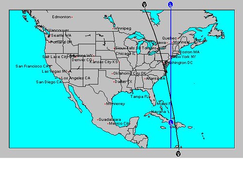
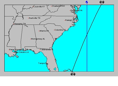
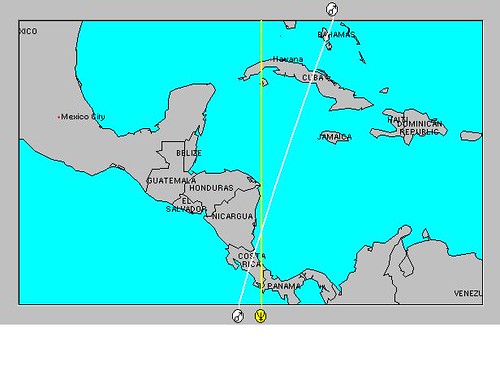
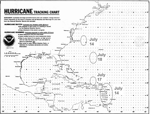
The long-range weather forecast for July 14-19, 2012 was posted on May 14th of this year. A number of predictions were made covering areas from the Lesser Antilles to New England. Some tropical activity was expected along with the possibility of other types of severe weather. Here's what happened. track_chart The above map was included with the forecast and showed the dates and places of possible tropical activity. I had circles the area over the Lesser Antilles and labeled it July 14th. Here's what the National Weather Service reported on this date: TROPICAL WAVE APPROACHING THE LESSER ANTILLES EXTENDS FROM 
20N60W TO 9N56W MOVING W NEAR 20 KT.

I also circled an area off the North Carolina and Virginia coasts to watch around the 14th as well. No tropical activity was reported although conventional meteorologists reported that North Carolina was the target for numerous thunderstorms on the 15th.

Around the 17th, I expected some sort of tropical activity just north of Hispaniola. On the 16th, the National Weather Service reported that a tropical wave was affecting the North Central Caribbean and the Bahamas. This wave along with daytime heating "HAS HELPED FORM CLUSTERS OF STRONG CONVECTION NEAR THE WAVE AXIS. ONE CLUSTER IS ACROSS HAITI FROM 18N-21N BETWEEN 72W-74W." This is basically the area mentioned in the forecast.   


On the 18th, I expected an area in and around 30 north latitude and 66-67 west longitude to produce some kind of tropical activity. Here's what the National Weather Service reported happening near there on the 18th.


AN UPPER LEVEL TROUGH IS TO THE E ALONG 30N62W TO AN UPPER LEVEL LOW IN 
THE CENTRAL CARIBBEAN. THE UPPER TROUGH SUPPORTS SOME ISOLATED
SHOWER/POSSIBLE THUNDERSTORMS FROM 120 NM EITHER SIDE OF A LINE
FROM HISPANIOLA TO 29N62W.

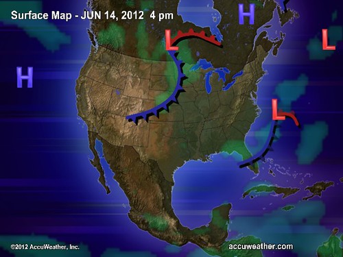
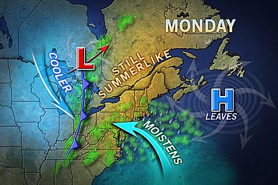
On the 19th it was over 29N65W. I, of course, was expecting stronger storm systems to manifest over these areas. So these tropical waves and upper level lows were small potatoes compared the storms that hit New England on the 17th and 18th. I had expected either a tropical system to lash the area or some other type of severe weather to do so. The Accuweather map below is for the 18th.
18 Vicious Storms

Accuweather said on the 17th that these beastly storms had the potential to produce intense gusts of wind, hail larger than quarters, and torrential, blinding downpours as well as perhaps spawn a tornado or two from New York state through New England. On the 18th, their headline ran: Vicious Storms Wednesday: Boston, NYC, Philly, DC.

Olympics Weather July 27- August 12, 2012
 Mars Conjunct Saturn August 15, 2012
Jupiter-Neptune and Heavy Rain
The Solar Eclipse of November 13, 2012
Long-range effects of the May 20, 2012 Solar Eclipse
Long-range effects of the May 20, 2012 Solar Eclipse Part 2
July 20-29, 2012 Long-range Weather Forecast
Hurricane Season 2011 Forecast Results
Hurricane Risk-Management
Texas Summer 2012
New Weather Alternative Website
Overview of UK Winter 2012-13
The Winters of 2011-14
Fulfilled Long-range Forecasts for Hurricane Season 2010
Introduction to the Weather Alternative

When you change the way you look at things, the things you look at change.” 
― Wayne W. Dyer

Saturday, July 21, 2012

Olympics Weather July 27- August 12, 2012

london6
The following forecasts are based on planetary cycles and are set for London, UK. Dates are approximate.


July 27-29: These days seem to indicate a windy weather pattern. There are a number of indications of a warm, southerly air flow indicating warm or hot temps. It's not clear how much precipitation is involved. A low or front may set up off the east coast of England.

July 31: Cool, dry weather

August 2: Fair

August 3: Increasing moisture brings a chance of rain. 

August 4: Southerly winds, rising temperatures. 

August 5: Fair conditions.  

August 6-9: Breezy to windy, warm, dry conditions. 

August 10-12: Southerly winds, warm temperatures, moderate humidity. 

Mars Conjunct Saturn August 15, 2012
Jupiter-Neptune and Heavy Rain
The Solar Eclipse of November 13, 2012
Long-range effects of the May 20, 2012 Solar Eclipse
Long-range effects of the May 20, 2012 Solar Eclipse Part 2
July 14-19, 2012 Hurricane Season Outlook
July 20-29, 2012 Long-range Weather Forecast
Hurricane Season 2011 Forecast Results
Hurricane Risk-Management
Texas Summer 2012
New Weather Alternative Website
Overview of UK Winter 2012-13
The Winters of 2011-14
Fulfilled Long-range Forecasts for Hurricane Season 2010
Introduction to the Weather Alternative

Sunday, July 15, 2012

Mars Conjunct Saturn August 15, 2012

Some of the most energetic weather patterns come on the heels of Mars-Saturn conjunctions. Windy, destructive storms attend the conjunction, parallel of declination, opposition, and square aspects. These are usually more intense during warm seasons. The next conjunction takes place on August 15, 2012. The last one formed on July 31, 2010. In this post, I'll look at four places that are affected by the next conjunction as well as upcoming dates when the Mars-Saturn conjunction should be spurred into action.

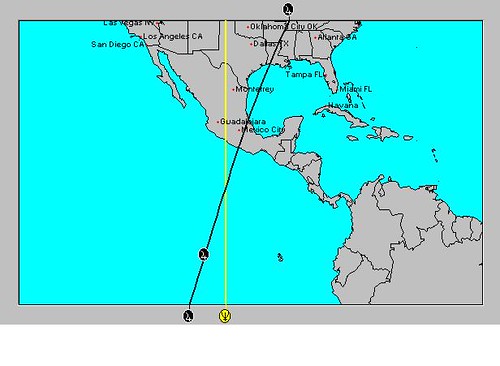
The first astro-locality map below shows Mars and Saturn affecting the 100th degree of west longitude running through the Plains and southward through Texas and Mexico. Two places stand out in particular. Mercury crosses Mars-Saturn over the Texas and Oklahoma panhandles, and, further south, the Moon crosses Mars and Saturn off the southern coast of Mexico approximately over 100 west longitude and 12 north latitude. So around the 15th of August we should see a severe weather pattern develop over the Plains with particular emphasis over the Texas and Oklahoma panhandles where destructive storms, perhaps generating hail, gusty winds, and tornadoes is possible. The crossing off the southern coast of Mexico should be watched around the 15th for the formation of tropical system.

US
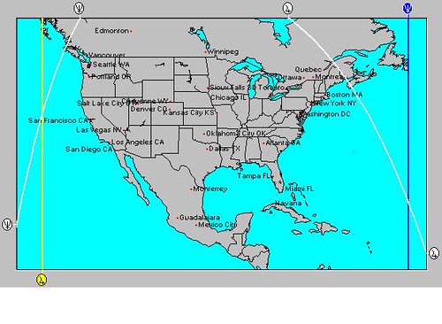
The next map shows Mars and Saturn, represented by the white lines, crossing Mercury, shown by the blue line, over the North Sea between England and Denmark. Around the 15th of August, this area should respond with a vigorous low pressure system or strong front.

Europe
The third map shows a crossing between the Moon and Mars-Saturn around 175 east longitude and 27 south latitude. This lies about 725 miles north of New Zealand. This area should be watched for the formation or passage of a tropical cyclone around the 15th of August.

  New Zealand
Activation Dates

The Mars-Saturn conjunction will be triggered on the following dates:
Sept 1, 2012
Oct 1, 2012
Oct 17, 2012
Nov 17, 2012

Although all four places discussed will be triggered on these dates and should respond with varying degrees of severe weather, here is a more detailed look at some of the activation dates.

Aug 29-Sept 2, 2012
The crossings over Mexico and New Zealand are activated now by Saturn and Venus.

Aug 30-Sept 2, 2012
The crossings over Texas/Oklahoma and Europe are emphasized now as Mars and Venus trigger them.

Oct 1-3, 2012
The Mexico and New Zealand crossings appear to be more active than the others due to Mercury's triggers.

Oct 17-19, 2012
The Mexico and New Zealand crossings once again receive more activation by the transit Sun.

Nov 17-19, 2012
Venus triggers the Mars-Saturn conjunction and gives extra energy to the Mexico and New Zealand crossings.

Jupiter-Neptune and Heavy Rain
Long-range effects of the May 20, 2012 Solar Eclipse
July 14-19, 2012 Hurricane Season Outlook
Hurricane Season 2011 Forecast Results
Hurricane Risk-Management
Texas Summer 2012
New Weather Alternative Website
Overview of UK Winter 2012-13
The Winters of 2011-14
Fulfilled Long-range Forecasts for Hurricane Season 2010
Introduction to the Weather Alternative

When and How did the Universe Begin?

Tuesday, July 10, 2012

Jupiter-Neptune and Heavy Rain

In recent posts I've talked about the effect of the Jupiter-Neptune square of June 25, 2012 and the Uranus-Pluto square of June 24, 2012. I've mentioned how one of the main influences of Jupiter-Neptune pertains to heavy rainfall. Here's another look at how this has played itself out since the square took place at the end of June and some dates and places where the effects should manifest again in the future.

One area that was directly affected by the Jupiter-Neptune square was the Philippine Islands. As can be seen from the astro-locality map below, the two planets crossed over the Philippines on June 25th at the time of the exact square. Phil

The very next day, Accuweather reported that Tropical Depression Doksuri formed east of the Philippines and would bring locally heavy rain to the islands as it made its way towards Hong Kong. The National Weather Service map below shows Doksuri affecting the islands on the 27th of June. 553285_321436724611891_604511869_n

Another important crossing occurred over eastern Canada between the Sun and Neptune as shown in the next astro-locality map. Newfoundland

On the 26th, this area of New England and eastern Canada was hit by heavy rainfall as shown in the map below. 26 Maine

Accuweather reported on the 26th that enough rain would fall on Maine and neighboring Canada on the 26th and 27th to cause localized flooding problems. The storm system was tapping into some tropical moisture from Debby which helped bring the drenching rain. As I pointed out in another post, the Uranus-Pluto square was also operating over this area and was also a contributor to the weather pattern.

The Jupiter-Neptune square will be triggered in upcoming months and we should look to these same areas--the Philippines and New England-Eastern Canada-- for reactions that also bring heavy rain although we should not expect a tropical depression in every case. Here are some dates when we could expect such weather.

August 25, 2012
September 2, 2012
October 5, 2012
October 11, 2012
November 2, 2012
November 10, 2012
November 24, 2012

Long-range Effects of the May 20, 2012 Solar Eclipse Part 2
Long-range effects of the May 20, 2012 Solar Eclipse
July 14-19, 2012 Hurricane Season Outlook
Hurricane Season 2011 Forecast Results
Hurricane Risk-Management
Texas Summer 2012
New Weather Alternative Website
Overview of UK Winter 2012-13
The Winters of 2011-14
Fulfilled Long-range Forecasts for Hurricane Season 2010
Introduction to the Weather Alternative

Faith expects from God what is beyond all expectation-- Andrew Murray

Sunday, July 01, 2012

TS Debby and June 22-30, 2012 Forecast Results

The original forecast was posted on May 7, 2012 and mainly focused on the effects of the approaching Uranus-Pluto and Jupiter-Neptune alignments on weather patterns. Although Jupiter-Neptune did not disappoint us as far as its potential for instigating tropical systems (Tropical Storm Debby), it did not correspond to an increase in moisture over the Plains and Mississippi Valley as I was expecting. In another post, I will delve into the Jupiter-Neptune square a bit more and offer some dates and locations that will experience their effect in the future.

The main event over the Plains and Mississippi Valley during the forecast period (June 22-30) was a heat wave breaking all-time records with triple-digit temperatures and gusty winds. How is this at all like Jupiter-Neptune's influence which is supposed to bring low pressure areas and increased precipitation? Well, according to G.J. McCormack, the 20th Century's most accurate and famous astrometeorologist, those are not the only manifestations of Jupiter-Neptune. According to McCormack we can also count on excessive humidity and higher ranges of temperature. This is more like what we got over the Central U.S. at that time. I should have included these other standard possibilities in the forecast.

Tropical Storm Debby

TS Debby formed right at the time of the Uranus-Pluto square (June 24) and the Jupiter-Neptune square (June 25). I believe the most important chart that accounts for Debby's track across northern Florida is the recent Solar Eclipse chart of May 20, 2012. Neptune and Jupiter made an important crossing right over the South Carolina-Georgia coasts at that time and we've seen a number of tropical systems form there (TS Alberto and TS Beryl) since the eclipse. My take is that Debby was being drawn toward that point. Here's the astro-locality map that shows the crossing over South Carolina and Georgia.

Eclipse

And here's the map of the track that conventional forecasters eventually decided on. 25 Debby Track

Conventional forecasters at first were a bit perplexed not knowing whether Debby would head west toward Mississippi and Louisiana or cut across Florida and head into the Atlantic. Here's their map for Debby's track issued the day before the one above.
24 TS Debbie

In my forecast, I mentioned Mississippi for severe weather at this time and on the 24th Debby was affecting as far west as Mississippi fulfilling that forecast. The National Weather Service reported that convection from Debby was not only affecting the Florida Peninsula but westward to 88 west longitude, which is in and around Mississippi.

On the other side of Florida, I mentioned that the New Moon Chart places a crossing near the Bahamas and that tropical activity may be possible there.
Jupiter Neptune


When you look at the New Moon's Jupiter-Neptune crossing and compare it with a satellite picture for the 25th, you can see how Debby's influence extended to that very area. So these astro-influences account for conventional forecasters' east-west track dilemma.


25 Tropics

I also mentioned an area off the south coast of Mexico where tropical storm formation was possible. There was a report by the Weather Channel on the 21st, stating, "A low pressure system continues focusing "Equatorial Express" moisture into the Pacific coast of Mexico with an ongoing threat of flash flooding and mudslides/landslides."

Uranus-Pluto

This forecast pinpointed the New England area for severe weather. On the 25th heavy rain hit New England and on the 26th the Accuweather headline stated Maine Rain Bringing Localized Flooding. Here's the Accuweathe map for the 26th.

26 Maine

The last portion of the forecast called for possible tropical storm development about 750 miles west of Cabo San Lucas. No storm formation was reported.

Long-range Effects of the May 20, 2012 Solar Eclipse Part 2
Long-range effects of the May 20, 2012 Solar Eclipse
July 14-19, 2012 Hurricane Season Outlook
Hurricane Season 2011 Forecast Results
Hurricane Risk-Management
Texas Summer 2012
New Weather Alternative Website
Overview of UK Winter 2012-13
The Winters of 2011-14
Fulfilled Long-range Forecasts for Hurricane Season 2010
Introduction to the Weather Alternative

Truth and Error

Error does not become Truth because it is widely accepted;
Truth does not become error, even when it stands alone!

Sunday, June 24, 2012

Texas Drought Update

Back in November of 2011, I posted an outlook for the Texas spring and summer of 2012. I commented on Neptune's role in astrometeorology as one of the planets that governs the moisture principle. Since Neptune appears over Texas in both the spring and summer charts for 2012, I concluded that moisture will begin to return more in earnest starting with the spring season. This pattern continues in the summer seasonal chart as well but apparently even more so.

I was reminded of this forecast the other day (June 20) when I read a comment on Accuweather.com about how crickets have invaded the Austin, Texas, area due to warm temperatures and recent rains. The combination of warmth and water has created near-perfect conditions for the hatching of cricket eggs. The report mentioned how that since the start of 2012, Austin has received 1.5 times its normal amount of rainfall and in May alone it received 200 percent of its normal rainfall for the month.

The maps below are from the U.S. Drought Monitor. The map on the left shows current drought conditions for June 2012, while the map on the right are drought conditions for Texas 8 months before during October 2011.

x-300x225

In an excellent article by Daniel Ramirez posted on June 21, 2012 and entitled In Drought, Texas Is No Longer "Exceptional" For Now, he explains that no portion of the state is in exceptional drought compared to last October. Despite the encouraging news, conventional forecasters see problems ahead as they're expecting more dry weather in the near future. Ramirez concludes his article with some good news: conventional meteorologists foresee a developing El Niño by late summer. This usually bodes well for Texas bringing normal to above normal rainfall. This could be what I'm seeing and commented on in my November post with Neptune's presence over Texas in the summer season chart.

Long-range Effects of the May 20, 2012 Solar Eclipse Part 2
Long-range effects of the May 20, 2012 Solar Eclipse
July 14-19, 2012 Hurricane Season Outlook
June 22-30, 2012 Long-range Weather Forecast
Hurricane Season 2011 Forecast Results
Hurricane Risk-Management
Texas Summer 2012
New Weather Alternative Website
Overview of UK Winter 2012-13
The Winters of 2011-14
Fulfilled Long-range Forecasts for Hurricane Season 2010
Introduction to the Weather Alternative

The DaVinci Code--Fact or Fiction?

Saturday, June 16, 2012

June 10-14, 2012 Forecast Results

Two forecasts were posted regarding the period between June 10-14, 2012. The first one was posted on April 29, 2012 and the second on May 19, 2012. The first forecast indicated that the New England and area and eastern Canada would be subject to windy and stormy conditions due to the aspects of Mercury to Uranus and Pluto. It also pinpointed an area about 480 miles off the North Carolina coast for low pressure formation. The second forecast pinpointed another area off the North Carolina coast for potential tropical storm development.

Results

On June 12th, Accuweather reported

Drenching Downpours Shift into Northeast
A surge of tropical moisture lifting into the Northeast ahead of an approaching front will set the stage for widespread showers and thunderstorms today. Downpours can produce locally up to an inch or more of rainfall in any given location, which can lead to urban and small stream flooding.

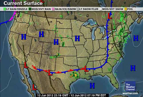
The Weather Channel reported "Rain and showers, measuring up to 1 inch, will shift eastward across New England, east New York and New Jersey Wednesday (June 13). Breezy conditions are likely along the Mid-Atlantic coast.

The Weather Channel map below is for June 12, 2012.
June 12

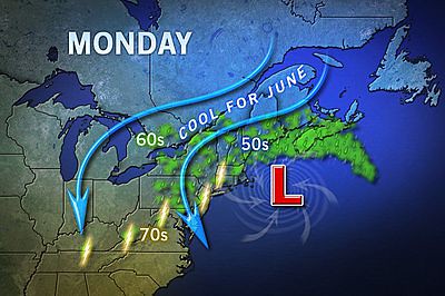
The Accuweather map below is for June 14th and shows the low pressure area off the North Carolina coast. The low did not develop tropical characteristics. On the 15th, Accuweather reported that this offshore low would help create cool coastal breezes and stiff winds with big waves along the Atlantic Seaboard. ussu0090

Long-range Effects of the May 20, 2012 Solar Eclipse Part 2
Long-range effects of the May 20, 2012 Solar Eclipse
July 14-19, 2012 Hurricane Season Outlook
June 22-30, 2012 Long-range Weather Forecast
Hurricane Season 2011 Forecast Results
Hurricane Risk-Management
Texas Summer 2012
New Weather Alternative Website
Overview of UK Winter 2012-13
The Winters of 2011-14
Fulfilled Long-range Forecasts for Hurricane Season 2010
Introduction to the Weather Alternative

The Wonder of Fathers

Sunday, June 10, 2012

The Solar Eclipse of November 13, 2012

In some recent posts we've looked at how the May 2012 solar eclipse will affect weather patterns. (See links below) In this post, I'm jumping ahead to the Solar Eclipse of November 13, 2012. This eclipse sets up some interesting planetary crossings around the world. As we've seen from the May eclipse, these crossings affect weather patterns at the time of the eclipse and latter on when the eclipse is activated. For now, we'll just look at the period of November 12-15, 2012, which is roughly the time when we should see a weather reaction. In a later post, I'll hopefully be able to list other dates when the eclipse will be triggered.

One recurring theme that we find in all the crossings that we'll look at is that involving the planet Neptune. As I've mentioned in other posts, Neptune's weather signature is that of rising temperatures and humidity, southerly winds, low pressure, fog, and heavy downpours. At the time of the eclipse, Neptune is in exact square with a retrograde Mercury, which increase the storm potential of Neptune.

United States

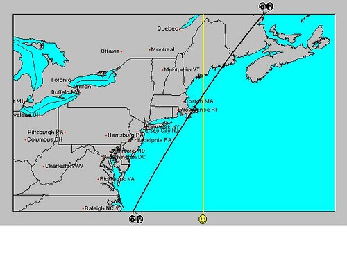
The first crossing we'll look at involves the U.S. and western Atlantic. The astro-locality map below shows two places where Neptune and Jupiter cross. U.S.

The first crossing in the western Atlantic falls around 53 west longitude and 23 north latitude. Since we are in hurricane season at this time, there is a strong possibility that a tropical storm or hurricane will either form around this area or be drawn to this area now.

The second crossing is off the U.S. West Coast around 133 west longitude and 41 north latitude. This crossing suggests a powerful low pressure area that could affect the U.S. and Canadian west coasts at this time.

South America

S.A.

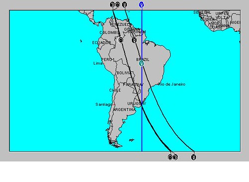
Neptune runs along the 53rd meridian of west longitude through Brazil and Uruguay. Mercury crosses Neptune over central Brazil where strong storms should develop. The Sun and Moon cross Neputne over Uruguay and Southern Brazil where storm emergenices are likely to develop at this time due to excessive precipitation.

Europe


Europe

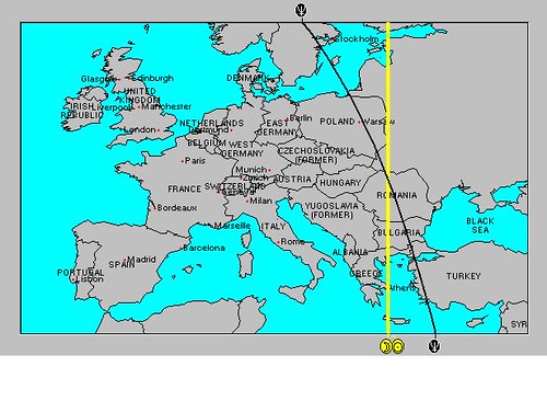
Another Sun-Moon-Neptune crossing takes place over Romania and western Russia. The area in and around this crossing run the risk of severe thunderstorms at this time. Heavy downpours are a common occurrence when the planet Neptune is square Mercury as in this case.

Korea

Korea

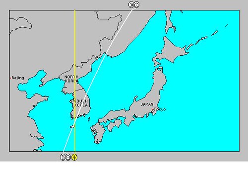
Most Pacific typhoons form bewteen May and November. Since this Sun-Moon-Neptune crossing forms within this time period, we can't rule out a typhoon, or at least some very powerful storm system, hitting South Korea at this time.

Long-range Effects of the May 20, 2012 Solar Eclipse Part 2
Long-range effects of the May 20, 2012 Solar Eclipse
July 14-19, 2012 Hurricane Season Outlook
June 22-30, 2012 Long-range Weather Forecast
June 10-12, 2012 Long-range Weather Forecast
Hurricane Season 2011 Forecast Results
Hurricane Risk-Management
Texas Summer 2012
New Weather Alternative Website
Overview of UK Winter 2012-13
The Winters of 2011-14
Fulfilled Long-range Forecasts for Hurricane Season 2010
Introduction to the Weather Alternative

Wednesday, June 06, 2012

June 4-7, 2012 Forecast Results

On April 22nd, I posted a forecast for the New England area for the period between June 4-7. Taking into account planetary configurations between the Sun, Moon, Venus, Mars, Uranus, and Pluto, I spoke of these forming an "X marks the spot" just off the southern coast of Maine. The idea was that there would be an atmospheric disturbance over the area resulting in severe storms, and, in the worst case scenario, an early tropical system. Here's the astro-locality map I included with the forecast. New England Astro

Soaking rain began to crawl through the New England area as early as June 2nd, a couple of days earlier than I anticipated. Maine and New Hampshire were to get between 2 and 4 inches. This storm system was to linger across northern New England throughout the 4th and 5th keeping New England cool and unsettled through the week. Compare the above astro-locality map with the Accuweather map depicting the low pressure area on Monday, the 4th. 03 Maine

The planetary crossing in the astro-locality map accurately depicts the location of the actual low pressure area. Today is the 6th and the National Weather Service is saying that the low is now over the maritimes and will begin to move eastwards late Thursday (7th). All in all the planetary indications accurately described the resulting weather. This forecast was made 43 days beforehand.

Long-range Effects of the May 20, 2012 Solar Eclipse Part 2
Long-range effects of the May 20, 2012 Solar Eclipse
July 14-19, 2012 Hurricane Season Outlook
June 22-30, 2012 Long-range Weather Forecast
June 10-12, 2012 Long-range Weather Forecast
Hurricane Season 2011 Forecast Results
Hurricane Risk-Management
Texas Summer 2012
New Weather Alternative Website
Overview of UK Winter 2012-13
The Winters of 2011-14
Fulfilled Long-range Forecasts for Hurricane Season 2010
Introduction to the Weather Alternative

More Interesting Horary Questions

"What will happen in 2012? Will the world end?"

"Was September 11 staged by the US Government?"


Sunday, June 03, 2012

July 20-29, 2012 Long-range Weather Forecast

The National Weather Service map below is for November 26, 2011. As you may recall, this weather pattern brought a drastic temperature roller coaster ride, high winds that created difficult travel conditions in the Plains, and two storm systems that combined bringing rain and snow from the Upper Midwest to the middle Mississippi Valley.  

By the 27th, five inches of rain doused eastern Tennessee and the southern Appalachians causing flash flooding as tropical moisture was drawn up from the south.

Nov 26

From an astrometeorological standpoint, this weather system was brought on by the Solar Eclipse of November 25, 2011. These Solar Eclipses stay active for a few years and can be jolted into action again and again when other planets trigger the eclipse degree. This particular Solar Eclipse will be activated once again around July 21, 2012. The activating planet in this case is Neptune. Its effect on weather patterns is to increase southerly airflow and moisture often resulting in increasing temperatures and heavy rain. Neptune's pluvial influence will also be operative in the Solar Ingress chart affecting the Plains and the Mississippi Valley into the Great Lakes area.

July 20-23, 2012
Based on the foregoing, I think we can expect an increase in moisture over the Plains resulting in higher temperatures and the activation of a storm center that has the potential to bring heavy rain. The low pressure area will then continue towards the east affecting the Mississippi Valley area into the Appalachians.

Solar Eclipse of January 4, 2011
This eclipse will also be triggered on July 27, 2012 by the square of Mars. In 2011, this eclipse had a history of bringing heavy rains in April and historic flooding in May to the Mississippi River Valley as well as other severe weather. Although the weather over the Mississippi Valley this time should not be as drastic as in 2011, there is the potential for above average moisture there and over the eastern half of the country. In addition, windy conditions are indicated over the Rockies.

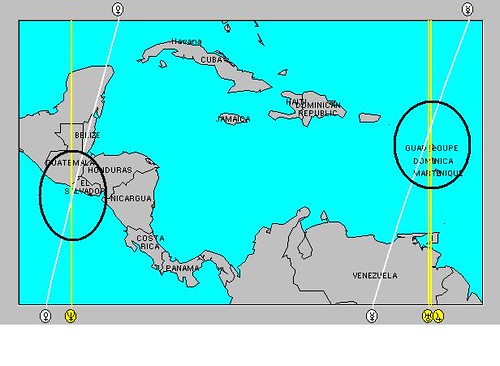
Another interesting feature of this eclipse is shown in the astro-locality map below. Venus and Neptune, at the time of the eclipse, focused their energies over the Pacific coasts of El Salvador and Guatemala. Mercury, Jupiter, and Uranus congregate over the Lesser Antilles. Both these areas will be activated now.

Caribbean July 26-29, 2012
We are likely to see weather patterns develop at this time over the Rockies where windy conditions or storms generating wind gusts are indicated. The Mississippi Valley and into the eastern part of the country should experience above-average moisture in the form of heavy rains. The tropics should spring to life over the Pacific coasts of El Salvador and Guatemala, as well as over the Lesser Antilles where tropical storm systems could develop.

Long-range Effects of the May 20, 2012 Solar Eclipse Part 2
Long-range effects of the May 20, 2012 Solar Eclipse
July 14-19, 2012 Hurricane Season Outlook
June 22-30, 2012 Long-range Weather Forecast
June 10-12, 2012 Long-range Weather Forecast
June 4-7, 2012 Long-range Weather Forecast
Hurricane Season 2011 Forecast Results
Hurricane Risk-Management
Texas Summer 2012
New Weather Alternative Website
Overview of UK Winter 2012-13
The Winters of 2011-14
Fulfilled Long-range Forecasts for Hurricane Season 2010
Introduction to the Weather Alternative

Astrology and Christianity
What do the stars say about Christianity? Here are some links to interesting astrological questions and their answers about Jesus, Bible prophecy, and modern theories about Jesus and Mary Magdalene.

Who Was Jesus?

Is the Anti-Christ Prophecy Coming True?

Did Mary Magdalene Bare a Child Fathered by Jesus?

Shall There Come an Anti-Christ and How Will We Know Him?


Saturday, May 26, 2012

Long-range Effects of the May 20, 2012 Solar Eclipse Part 2

In the first post regarding the long-range effects of the May 20, 2012 Solar Eclipse on weather patterns, I talked about two areas that will be affected when the eclipse degree is triggered in the future by other planetary transits. The first area is about 350 miles east of the South Carolina coast around 73 west longitude and 33 north latitude, and the second area is off the eastern coasts of Nicaragua and Costa Rica in the southwestern Caribbean.

In this post, I'll mention other geographical areas that will be affected each time the eclipse degree is triggered. These times will match with the times mentioned in the first post because those are also based on triggers to the Solar Eclipse degree. So where are these other areas? The areas are circled in the astro-locality map below.

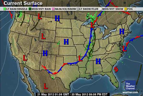
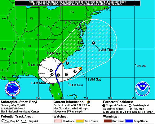
Eclipse The circled areas all have one thing in common: they are areas where two planetary lines cross. Probably the most important one is the area over South Carolina because here the crossing is between the two slow-moving, outer planets Jupiter and Neptune. Let's look at the brief history of this crossing. As can be seen in the Weather Channel map below for May 20th (the day of the eclipse), Tropical Storm Alberto formed there the day before. May 20 Then on May 24th, Mercury conjoined the eclipse degree and Subtropical Storm Beryl began to form there as shown in the National Weather Service map below.

26- TS Beryl Similar arguments can be made about the other crossings. For example the crossings over the Mid-Atlantic and Northeast were also active after the eclipse began on the 20th. The map below, for the 21st, shows a cold front setting off storms over that area and moisture being pumped in from--of all places-- the circled area about 350 miles off of South Carolina. Accuweather reported that "The rain and clouds are advancing in from the Atlantic, but that moisture is not associated with Tropical Storm Alberto." When Mercury triggered the eclipse on the 24th, the Mid-Atlantic and Northeast once again experienced showers and thunderstorms. 21 Northeast The last crossing is the one in the central Caribbean around 80W/17N. This became active around the 24th when Mercury triggered the eclipse degree and generated the beginnings of what is now Subtropical Storm Beryl. On the 25th, the NWS reported " SCATTERED STRONG CONVECTIVE PRECIPITATION...FROM 18N TO THE ATLANTIC OCEAN COAST OF CUBA BETWEEN 78W AND 83W...THIS AREA HAS BEEN CLOUDY AND RAINY FOR THE LAST FOUR TO FIVE DAYS. (That would mean since the time the eclipse took place) ENVIRONMENTAL CONDITIONS ARE EXPECTED TO BECOME MORE CONDUCIVE FOR THE FORMATION OF A SUBTROPICAL OR TROPICAL CYCLONE BY SATURDAY OR SUNDAY.

So in addition to the times and places mentioned in the first post, the following weather patterns should be expected on the dates listed below:

1- Tropical systems to affect the area in and around South Carolina. If not an actual tropical system, the weather pattern may manifest as a subtropical system or as an increase in troipcal moisture being pumped into the region resulting in drenching rains.

2- Thunderstorm activity over the Mid-Atlantic and Northeast.

3- Tropical system development or strong troughs to develop in the central Caribbean area resulting in deep layer moisture and precipitation.

4- The approximate dates in 2012:
June 13-14
August 21-24
September 1-3
October 2-4
October 6-8
October 28-30
November 10-14
November 20-22

Long-range effects of the May 20, 2012 Solar Eclipse
July 14-19, 2012 Hurricane Season Outlook
June 22-30, 2012 Long-range Weather Forecast
June 10-12, 2012 Long-range Weather Forecast
June 4-7, 2012 Long-range Weather Forecast
Hurricane Season 2011 Forecast Results
Hurricane Risk-Management
Texas Summer 2012
New Weather Alternative Website
Overview of UK Winter 2012-13
The Winters of 2011-14
Fulfilled Long-range Forecasts for Hurricane Season 2010
Introduction to the Weather Alternative

Are There Logical Reasons to Believe that God Exists?

Saturday, May 19, 2012

Long-range effects of the May 20, 2012 Solar Eclipse

In astrometeorology (the study of planetary influences on earthly weather patterns), solar eclipses are useful tools used in forecasting future weather patterns. A solar eclipse is much like a New Moon in this regards except that it has a longer life span. The influence of a solar eclipse is thought to be active for about 3 to 3 and a half years. At the exact moment of conjunction between the Sun and Moon a chart or map is set up. Note is taken of where all the planets were angular (rising, setting, exactly above, and exactly beneath the observer's reference point) at the time. These positions then are used to determine where certain weather patterns will develop and at what times.

The solar eclipse of May 20, 2012 sets up some important sensitive points in the northern and western hemispheres that will be activated over the coming months and carry the promise of severe weather when activated. Here are some brief explanations and time frames. Southeast The first place lies about 350 miles off the South Carolina coast. Here we see a crossing between the Sun and Moon, which were setting at that time, and Mars, which was directly overhead. The idea is that when these positions are activated later on by other planets arriving at those zodiacal degrees they held, certain weather patterns will develop there.

June 13-14
On these dates, the planet Jupiter will arrive at the exact degree the Sun and Moon held at the time of eclipse, and Venus will arrive at the square or 90 degree point to the position that Mars held. This carries the potential for the development of a tropical system around this area (73W/33N) in and around these dates.

Central America

An even more important set up occurs off the eastern coasts of Nicaragua and Costa Rica as seen in the map below. Caribbean Here we find that at the time of the eclipse the Sun and Moon were setting over this area and the planet Neptune was directly below any observer at that point. In astrometeorology, Neptune is known for its tendency to increase tropical moisture. This implies that, when activated, tropical systems may develop here--or at least tropical moisture will be abundant even if a tropical low does not specifically form.

August 21-24
At this time Sun will trigger the solar eclipse degree and oppose Neptune. Watch for a possible tropical system or heavy rains to affect the area in and around the east coasts of Nicaragua and Costa Rica.

September 1-3
Around this time Mercury will activate the solar eclipse and oppose Neptune once again increasing the likelihood of heavy rains or a tropical system over the eastern coasts of Honduras and Nicaragua. At this time the abovementioned area about 350 miles of the South Carolina coast will also be activated, indicating a possible tropical system or severe weather there.

October 2-4
Venus will spark the solar eclipse now and also oppose Neptune off the eastern coasts of Nicaragua and Costa Rica. The Venus-Neptune combination charges the atmosphere with saturating humidity provoking heavy downpours. This may manifest as a tropical system.

October 6-8
Right on the heels of Venus' opposition to Neptune we find Mars triggering the solar eclipse and squaring Neptune over the same area. Torrential downpours from acute storms (possibly a tropical system) correlate with Mars-Neptune aspects.

October 28-30
Mercury will perform the same manuever instigating tropical rains in and around Nicaragua and Costa Rica.

November 10-14
Both Mercury and Neptune will now activate the solar eclipse and square each other. Indications in another key chart adds to this itimating that any storm system developing over Nicaragua and Costa Rica now could be very powerful.

November 20-22
The Sun activates the solar eclipse and Neptune increasing tropical moisture while other indications show Mercury and Mars add powerful winds into the mix. This sounds like a tropical system over Nicaragua and Costa Rica.

Based on similar astrometeorological long-range techniques, I was able to predict 10 tropical systems that developed during Hurricane Season 2011. Hurricane Season 2011 Forecast Results

July 14-19, 2012 Hurricane Season Outlook
June 22-30, 2012 Long-range Weather Forecast
June 10-12, 2012 Long-range Weather Forecast
June 4-7, 2012 Long-range Weather Forecast
Hurricane Season 2011 Forecast Results
Hurricane Risk-Management
Texas Summer 2012
New Weather Alternative Website
Overview of UK Winter 2012-13
The Winters of 2011-14
Fulfilled Long-range Forecasts for Hurricane Season 2010
Introduction to the Weather Alternative

Monday, May 14, 2012

July 14-19, 2012 Hurricane Season Outlook

We continue to look at how the Uranus-Pluto and Jupiter-Neptune squares will possibly affect weather patterns during Hurricane Season 2012. This post looks at the time period between July 14-19. At this time Uranus and Mercury will make their retrograde stations, the Sun will square Saturn, and more importantly, Mars will trigger the close Uranus-Pluto square by first squaring Pluto and then opposing Uranus on the 17th and 18th.

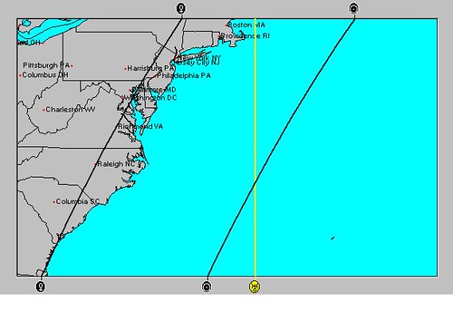
Aspects of this sort by Mars to Uranus and Pluto usually coincide with very energetic weather patterns provoking high wind velocities and dangerous atmospheric conditions. There is a contrary influence at work during this time as Jupiter moves into a sextile aspect with Uranus. This influence usually manifests with fair weather patterns. Be that as it may, I think that it will be difficult for that aspect to completely override the Mars-Uranus-Pluto influence. track_chart The above map shows the locations that various planetary alignments are likely to affect as we approach the Mars aspects on July 17th and 18th. The 14th shows that there is the potential for a storm system to develop around the Windward Islands. There is also another influence setting up off the North Carolina and Virginia coasts. The 17th highlights an area north of Puerto Rico, and the 18th pinpoints another just southwest of Bermuda.

Except for the area off the North Carolina and Virginia coasts on the 14th, the other areas seem to form a natural progression from south to north between the 14th and the 18th starting at the Windward Islands. The key Solar Ingress chart for the season places the Uranus-Pluto influence over the New England area so one possibility is that a tropical system forms around the 14th over the Windward Islands and moves northward with its eyes on New England.

Of course, there is always the possibility that some other type of severe weather is indicated by these alignments that is not tropical in nature. In such a case, other types of severe storms may affect the New England area at this time.

June 22-30, 2012 Long-range Weather Forecast

June 10-12, 2012 Long-range Weather Forecast

June 4-7, 2012 Long-range Weather Forecast

Hurricane Season 2011 Forecast Results

Hurricane Risk-Management

Texas Summer 2012

New Weather Alternative Website

Overview of UK Winter 2012-13

The Winters of 2011-14

Fulfilled Long-range Forecasts for Hurricane Season 2010

Introduction to the Weather Alternative

Monday, May 07, 2012

June 22-30, 2012 Long-range Weather Forecast

This is the next in a series of posts that analyzes the squares between Jupiter-Neptune and Uranus-Pluto and their effect on weather patterns. Both these square are exact at the end of June. The square between Jupiter and Neptune indicates predominant low barometric pressure and above normal precipitation. The configuration between Uranus and Pluto brings storm emergencies with sharp dips in temperatures and erratic gusty winds.

The Jupiter-Neptune Square

This aspect is exact on June 24th and 25th and is later triggered again on June 28th. The Solar Ingress chart for the summer season places Neptune along the 101st degree of west longitude which passes through western Texas, along the Front Range of the Rockies, and through the High Plains. Jupiter affects eastern Texas, the central Mississippi River Valley, and the Great Lakes. These are areas that should generally receive above normal precipitation at this time.

As we look at the combined influence of Jupiter and Neptune in other key charts such as Solar Eclipse charts and New and Full Moon charts, we get some other interesting scenarios. For example, the New Moon chart of June 19th places an important crossing of Jupiter and Neptune in the western Atlantic about emphasizing the area from Haiti northward for about 550 miles as shown in the astro-locality map below.
   Jupiter Neptune
This area could be the spawning grounds of a tropical system. Since Jupiter and Neptune also affect the coasts of North Carolina and Virginia and continue into the Northeast, the chance exists of a tropical system heading towards those areas at this time. Sometimes it's not an actual tropical system that forms. This configuration can represent the presence of abundant tropical moisture that is pumped up into the area.

As Jupiter perfects its square to Neptune, it will also trigger the Solar Eclipse of November 25, 2011. This will sensitize the 96th degree of west longitude which runs through Dallas, Texas northward into the Plains. Neptune also affects Texas and the Plains. This could argue that tropical moisture from the Gulf of Mexico is pulled northward into Texas pushing its way into the Plains. The mechanism that brings this about could be a low pressure area, front, or even a tropical system in the Gulf.

Another interesting scenario develops in the Solar Ingress chart as shown in the astro-locality map below. Ju Ne Mex


Here we see Jupiter and Neptune crossing in the eastern Pacific at 101 west longitude and 10 north latitude or about 550 miles south of the Mexican coast. This indicates the possibility of a tropical system forming around this area now.

The Uranus-Pluto Square

The Uranus-Pluto square is exact on June 24th but is triggered a bit earlier on the 22nd. The Moon will activate it again on the 27th, and finally the Sun will square and oppose them on the 29th. The Solar Ingress chart has them affecting the eastern U.S. and New England. We've already seen that the Jupiter-Neptune configuration affects the East Coast, so this is another influence happening simultaneously.

Two other places that might be worth watching are in and around the state of Mississippi where severe weather could develop and around the 29th about 750 miles west of Cabo San Lucas (121 west/23N) where a tropical system could develop or pass.

June 10-12, 2012 Long-range Weather Forecast

June 4-7, 2012 Long-range Weather Forecast
Hurricane Season 2011 Forecast Results
Hurricane Risk-Management
Texas Summer 2012
New Weather Alternative Website
Overview of UK Winter 2012-13
The Winters of 2011-14
Fulfilled Long-range Forecasts for Hurricane Season 2010
Introduction to the Weather Alternative

Sunday, April 29, 2012

June 10-12, 2012 Long-range Weather Forecast

Mercury will activate the approaching Uranus-Pluto square on June 11th by first forming a square to Uranus and then an opposition to Pluto. The Moon then enters the picture on the 12th by conjoining Uranus and squaring Pluto. Since earthly weather patterns respond to these planetary alignments as amply attested to on the pages of this blog, our purpose here is to determine the type of weather pattern that will ensue as well as the place.

A number of key charts such as the Solar Ingress, Full Moon, and Last Quarter Moon charts concentrates the Uranus-Pluto influence over the eastern U.S. especially the New England and eastern Canada area. Since the square of Mercury to Uranus excites wind velocities, cold, and stormy conditions, and the opposition of Mercury to Pluto also brings cold fronts and storminess, this could be a time of increased storminess over the areas mentioned above.
June 11
The area around 69 west longitude and 34 north latitude which lies about 480 miles east of the North Carolina coast may show the development of a low pressure system or cold front at this time. There is only one influence in the New Moon chart that seems to contradict all of the above. Since this New Moon is an eclipse, it may be important. Transit Jupiter will conjoin the solar eclipse degree and may bring a warm and fair influence that will compete with the cold and storminess of Mercury, Uranus, and Pluto.

June 4-7, 2012 Long-range Weather Forecast

Hurricane Season 2011 Forecast Results

Hurricane Risk-Management

Texas Summer 2012

New Weather Alternative Website

Overview of UK Winter 2012-13

The Winters of 2011-14

Fulfilled Long-range Forecasts for Hurricane Season 2010

Introduction to the Weather Alternative

Sunday, April 22, 2012

June 4-7, 2012 Long-range Weather Forecast

During hurricane season 2012, the outer, slower moving planets will form some disruptive aspects that could be instrumental in aggravating hurricane formation this year. These aspects involve the square between Jupiter and Neptune, and the square between Uranus and Pluto. New-England-Map-new-england-83553_400_525 At the beginning of June, Uranus and Pluto are almost exact in their square being less than a degree away. This almost exact aspect may be "close enough for Jazz" in the sense that their influence on weather patterns manifests as the Moon and other planets trigger them even before they are exact.

In the next posts we'll be looking at different weather scenarios that develop during hurricane season and that involve these outer planetary aspects as well as other important ones.

Between the 4th and 7th of June, there are some interesting planetary aspects that affect the New England area. Venus will square Mars on the 4th, the same day as the Full Moon, which is a SuperMoon since the Moon is at its closest approach to Earth. Then on the 5th and the 7th, the Sun will conjoin Venus and square Mars, once again triggering the Venus-Mars square. On the 5th, the Moon will square Uranus and conjoin Pluto activating their approaching square.

The Solar Ingress chart on the 5th shows the Sun-Venus conjunction crossing Uranus at 69 degrees west longitude as it the Moon squares it. This "X marks the spot" just off the southern coast of Maine represents an area of possible severe weather. New England Astro

The square between Venus and Mars always coincides with increasing temperatures. The Sun's conjunction to Venus is accompanied by pluvial indications and the Sun's square to Mars disrupts the atmosphere. If nothing else, we may see a dramatic increase in temperatures over New England, but with the Uranus-Pluto square being triggered as well, bringing a colder air mass into the picture, along with the disruptive influences already mentioned, I'm thinking that there will be atmospheric disturbance over the area. This might manifest in severe storms or as a worst case scenario, a possible early tropical system.

Hurricane Season 2011 Forecast Results

Hurricane Risk-Management

Texas Summer 2012

New Weather Alternative Website

Overview of UK Winter 2012-13

The Winters of 2011-14

Fulfilled Long-range Forecasts for Hurricane Season 2010

Introduction to the Weather Alternative

Thursday, April 12, 2012

Understanding the Warmth of Winter 2011-12 Part 2

On March 24th of this year, Accuweather.com posted an article entitled "Amazing Stats from the March 2012 Heat Wave." The article points out how thousands of high temperature records were broken over the preceding couple of weeks from the High Plains to the East Coast and northward into Canada.

If we look back to see what was happening astrometeorologically a couple of weeks before we are not disappointed to find a very logical answer to this phenomena: the conjunction of Venus and Jupiter on March 14th along with the trine of Venus to Mars, and the trine of Mars to Jupiter all on the same day.


10 March Warmth

Now, can we safely say that a Venus-Jupiter conjunction and the trines of Venus, Mars, and Jupiter have been known by previous experience to correspond with increasing temperatures? A quick look at G.J. McCormack's Astrotech Weather Guide provides the following information. The conjunction of Venus and Jupiter is conducive to a temperate atmosphere that favors out-of-door activities. The trine of Venus to Mars inclines to fair weather and higher ranges of temperature. And the trine of Mars to Jupiter is indicative of rising temperatures with dryness. So all in all, we have a strong previous track record of increasing temperatures with these three planets. What probably added to the impact was the fact that they all were in aspect to each other on the same day.

The astro-locality map shows the position of the Venus-Jupiter conjunction in the New Moon chart for that period. The conjunction and other aspects were affecting the central U.S. Weather patterns then usually travel eastward.

Venus Jupiter

This is another piece of the puzzle explaining the warmth experienced in the last half of March and this information will be taken into account when assessing the next few winters.


Hurricane Season 2011 Forecast Results

Hurricane Risk-Management

Texas Summer 2012

New Weather Alternative Website

Overview of UK Winter 2012-13

The Winters of 2011-14

Fulfilled Long-range Forecasts for Hurricane Season 2010

Introduction to the Weather Alternative

Tennessee Enacts Academic Freedom Law Protecting Teachers Who Present Both Sides of Evolution Debate

Tennessee became the latest state to enact an academic freedom bill that protects teachers when they promote critical thinking and objective discussion about controversial science issues such as biological evolution, climate change and human cloning. Read the article

Thursday, April 05, 2012

Understanding the Warmth of Winter 2011-12

Based on my January 24, 2011 post entitled The Winters of 2011-14, I wrote an article for The Mountain Astrologer magazine. It carried the same message: colder winters for 2011-14. In the article, I issued specific forecasts for the United States, Europe, and China. I've been posting the results of these forecasts over the last few months. As far as these individual forecasts go, I was quite pleased with their accuracy, but not as far as the overall cold I expected.

However, it seems that Europe did have a cold winter to speak of. Europe experienced a time of brutal cold more in line with what I was expecting. Accuweather posted some sad news on February 5th in its headline “Europe Cold Wave Death Toll Nears 300.” So, while my individual forecasts fared well, the overall U.S. winter forecast needs to be examined to learn where improvements can be made. Situations like this one, when all is said and done, can make future forecasts more accurate as a better understanding is gained of the astrometeorological process.

The January 27th Accuweather headline stated that “January 2012 Breaks Heat, Cold, Snow and Tornado Records.” The cold referred to in that headline was in Alaska and snowfall records were broken in 23 states. In spite of this, the overall U.S. winter was a warm winter when all was said and done. The cold weather that I forecast was based on the position of Uranus in the season's key chart and it's approaching square to Pluto. And although Uranus did in just about every instance bring wintry weather when aspected, there were other factors at work as well. It seems, in retrospect, that Mars lingering on the ascendant throughout the Plains brought a lot of the heat experienced throughout the winter there.

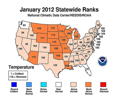
For example, according to the National Climate Data Center map below, the warmest states on average for the month of January were the orange colored ones.

09 2012 Jan Temps

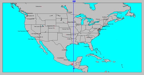
Now, in astrometeorology, the planet Mars is the author of such warmth. By looking at its position in the Cardinal Solar Ingress for the winter season, we can see how it coincides beautifully with the heat that was experienced. The white line in the map below shows Mars' position.

Jan

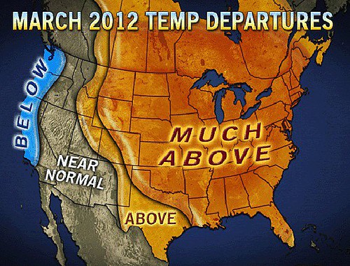
The areas of the U.S. that experienced temperatures higher than the average for the month of February 2012 are shown in the Climate Prediction Center's map below. The redder the color, the higher the departure from normal.

febtan12

The position of Mars in the Cardinal Solar Ingress for the winter season had changed a bit by the beginning of February and is shown in the astro-locality map below.

Feb
Notice the white line representing Mars had also moved eastward just as the higher average temperatures had moved eastward as well.
I believe this was an important overlooked key that will make other future forecasts based on astrometeorology more reliable and accurate. Now it remains to be seen if this type of information will change the outlook for the next few winters as mentioned in my original post.

Hurricane Season 2011 Forecast Results

Hurricane Risk-Management

Texas Summer 2012

New Weather Alternative Website

Overview of UK Winter 2012-13

The Winters of 2011-14

Fulfilled Long-range Forecasts for Hurricane Season 2010

Introduction to the Weather Alternative