Click here for September 2006 Hurricane and Severe Weather Outlook
Click here for the Introduction to The Weather Alternative
Scroll down and check out fulfilled long-range forecast.
Oct 4-6:
A cold front over the Mississippi Valley triggers storms that push eastward.
Oct 5-7:
Storms hit from coastal North Carolina and Virginia through the Northeast.
A tropical moisture is indicated over the Bahamas, Cuba, and Jamaica.
A storm system will advance into the Pacific Northwest and Intermountain West, pushing showers and thunderstorms into those areas.
Oct 7-9:
Cold air funnels in over the Plains and pushes eastward triggering storms that eventually reach the Southeast, Mid-Atlantic, and Northeast.
Oct 8-10:
A storm system moves in over the West Coast States and pushes toward the Rockies.
Oct. 10-12:
Storms should rev up over the Plains and West Coast. After the 12th, falling temperatures and windy conditions are in store for the eastern U.S.
Oct 11-13:
Low pressure brings rain to the Bahamas, Cuba, and Jamaica. Storms will affect the coastal area of Florida, Georgia, and South Carolina.
Oct. 15-18:
The general weather pattern over California begins to change now as a warmer more moisture-laden air mass enters the region. This may result in tropical moisture being funneled into the area setting off heavy showers. Fog may also be a concern now.
Abundant moisture is also drawn up over the Plains creating severe weather potential along the Front Range of the Rockies.
The Mid-Atlantic States will have to deal with what promises to be some good-sized storms of their own.
Oct 19-21:
Showers and storms hit the Northeast down through Virginia, the coastal areas of Florida, Georgia, and South Carolina, as well as the Bahamas, Cuba, and Jamaica.
Oct. 19-21:
Storms continue to kick out into the Plains as contrasting air masses feed low pressure systems. The West Coast gets a new round of storms while temperatures drop over the eastern U.S.
Oct. 22-25:
A new wave of inclement weather reaches the West Coast States. The period climaxes with the potential for tempestuous, widespread storms and heavy downfall. The Plains should respond with an outbreak of severe weather, which may include possible tropical storm implications along the southwest coast of Texas.
The potential for major tropical activity is also shown for the eastern coast of India.
The eastern U.S. should be dealing with its own weather anomalies as temperatures skyrocket. The atmosphere may try and equalize the situation by unleashing strong storms over the Southeast and Mid-Atlantic regions. A tropical system cannot be ruled out.
Another Hurricane Hot Spot may develop off the eastern coast of Nicaragua threatening Central America, while the island of Jamaica is in for severe weather as well.
Oct 25-27:
A vigorous low pressure system will trek across the Rockies generating strong storms.
Oct 28-30:
A low pressure system off the California coast will hurl wind and rain into California and Oregon. Major changes should be underway for the Plains as well. A whirling dervish of a storm center over northern Minnesota and Wisconsin will most likely usher in windy conditions. Tropical moisture from the Gulf will help ignite hefty storms over the Ark Latex region.
A Hurricane Hotspot forms in the Eastern Pacific at 94 West Longitude and 10 North Latitude or about 400 miles south of Oaxaca, Mexico.
Thursday, September 28, 2006
Wednesday, September 27, 2006
Soaking Rain for the Northeast
Click here for September 2006 Hurricane and Severe Weather Outlook
Click here for the Introduction to The Weather Alternative
The Weather Alternative's long-range forecast (prepared in December 2005) for September 26-28 is shaping up just fine. The forecast called for The potential for heavy rainfall is shown over the eastern US from the eastern Great Lakes southward to Virginia.
Here's the latest from Accuweather:
 The front moving through the Great Lakes today will reach Pennsylvania and western New York by Thursday, bringing cloudy, damp weather and noticeably cooler air. The wettest weather in the coastal mid-Atlantic will come on Thursday night, and Friday looks like a washout for New England. To add insult to injury, the upper-level trough that is pushing this front along will be lifting up to the north, meaning the front will be slowing down. So, while places in the Great Lakes will just be having a quick spell of rain today, much of the Northeast will have a soaking rain for a longer period of time.
Click here for the Introduction to The Weather Alternative
The Weather Alternative's long-range forecast (prepared in December 2005) for September 26-28 is shaping up just fine. The forecast called for The potential for heavy rainfall is shown over the eastern US from the eastern Great Lakes southward to Virginia.
Here's the latest from Accuweather:
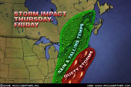 The front moving through the Great Lakes today will reach Pennsylvania and western New York by Thursday, bringing cloudy, damp weather and noticeably cooler air. The wettest weather in the coastal mid-Atlantic will come on Thursday night, and Friday looks like a washout for New England. To add insult to injury, the upper-level trough that is pushing this front along will be lifting up to the north, meaning the front will be slowing down. So, while places in the Great Lakes will just be having a quick spell of rain today, much of the Northeast will have a soaking rain for a longer period of time.
Sunday, September 24, 2006
Strong Storms for Eastern US
Click here for September 2006 Hurricane and Severe Weather Outlook
Click here for the Introduction to The Weather Alternative
The strong storms affecting the US East Coast are a direct fulfillment of the following long-range weather forecast. This forecast was prepared in December 2005, published in the July 2006 edition of Dell Magazine and posted on this blog in August 2006.
Forecast
Sept. 24-26:
A blast of cold air will assault the Mid-Atlantic and Southeast generating gusty winds and slashing temperatures.
Today Accuweather published the following map and comment.
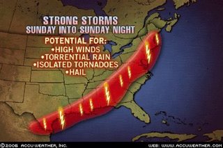
The storm system that has pounded the Midwest and Mississippi Valley with severe weather recently will sweep southward and eastward this afternoon, spreading the severe weather threat from Bangor, Maine, to Albany, Georgia, and into Brownsville, Texas. The AccuWeather.com Severe Weather Center is urging residents or visitors across these areas to keep an eye to the sky and check back to AccuWeather.com as any of these thunderstorms has the potential to produce damaging winds, heavy rain and hail. In addition, isolated tornadoes cannot be ruled out.
In addition to the above forecast, The Weather Alternative also forecast the following:
Sept. 23-25:
A tropical weather system may be brewing near the Dominican Republic and tropical moisture unloads over the Florida Panhandle.
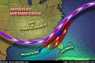 Accuweather reports: A frontal boundary will stall across northern and central Florida through the middle of the week. Moist air will continue to spread up along the front from Monday to Wednesday, leading to widespread showers and thunderstorms. The heaviest rainfall during the period will likely be from Gainesville to Orlando, Fla.
The National Weather Service published the following about the Dominican Republic:
TROPICAL WAVE IS OVER THE LESSER ANTILLES ALONG 62W S OF 20N MOVING SLOWLY WESTWARD AT AROUND 10KT. BROADENING INVERTED-V SIGNATURE CURVATURE WITH SCATTERED SHOWERS/ISOLATED THUNDERSTORMS FROM 13N-18N BETWEEN 58W-64W. THIS WAVE WILL MOVE ACROSS THE VIRGIN ISLANDS AND PUERTO RICO LATE TODAY TROUGH MONDAY AND IS EXPECTED TO REACH DOMINICAN REPUBLIC MONDAY AFTERNOON OR EVENING...INCREASING THE CHANCE OF RAIN OVER THOSE ISLANDS.
Click here for the Introduction to The Weather Alternative
The strong storms affecting the US East Coast are a direct fulfillment of the following long-range weather forecast. This forecast was prepared in December 2005, published in the July 2006 edition of Dell Magazine and posted on this blog in August 2006.
Forecast
Sept. 24-26:
A blast of cold air will assault the Mid-Atlantic and Southeast generating gusty winds and slashing temperatures.
Today Accuweather published the following map and comment.
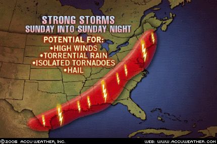
The storm system that has pounded the Midwest and Mississippi Valley with severe weather recently will sweep southward and eastward this afternoon, spreading the severe weather threat from Bangor, Maine, to Albany, Georgia, and into Brownsville, Texas. The AccuWeather.com Severe Weather Center is urging residents or visitors across these areas to keep an eye to the sky and check back to AccuWeather.com as any of these thunderstorms has the potential to produce damaging winds, heavy rain and hail. In addition, isolated tornadoes cannot be ruled out.
In addition to the above forecast, The Weather Alternative also forecast the following:
Sept. 23-25:
A tropical weather system may be brewing near the Dominican Republic and tropical moisture unloads over the Florida Panhandle.
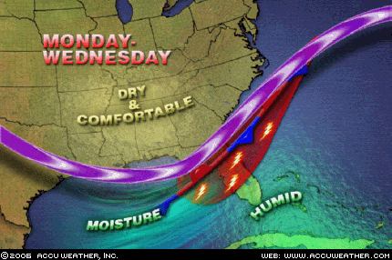 Accuweather reports: A frontal boundary will stall across northern and central Florida through the middle of the week. Moist air will continue to spread up along the front from Monday to Wednesday, leading to widespread showers and thunderstorms. The heaviest rainfall during the period will likely be from Gainesville to Orlando, Fla.
The National Weather Service published the following about the Dominican Republic:
TROPICAL WAVE IS OVER THE LESSER ANTILLES ALONG 62W S OF 20N MOVING SLOWLY WESTWARD AT AROUND 10KT. BROADENING INVERTED-V SIGNATURE CURVATURE WITH SCATTERED SHOWERS/ISOLATED THUNDERSTORMS FROM 13N-18N BETWEEN 58W-64W. THIS WAVE WILL MOVE ACROSS THE VIRGIN ISLANDS AND PUERTO RICO LATE TODAY TROUGH MONDAY AND IS EXPECTED TO REACH DOMINICAN REPUBLIC MONDAY AFTERNOON OR EVENING...INCREASING THE CHANCE OF RAIN OVER THOSE ISLANDS.
Thursday, September 21, 2006
Large Storm for Central U.S.
Click here for September 2006 Hurricane and Severe Weather Outlook
Click here for the Introduction to The Weather Alternative
Conventional meteorologists, over the last couple of days, have realized that a potent storm system is taking shape over the Central U.S. This was forecast by The Weather Alternative back in December 2005 and posted this blog on August 24, 2006. The forecast is repeated below.
Forecast
Sept. 21-23:
The insurgence of warm, moist air over the Gulf Coast States from Texas to Florida will act as a potential storm breeder on its journey northward into the central U.S.
Click here for the Introduction to The Weather Alternative
Conventional meteorologists, over the last couple of days, have realized that a potent storm system is taking shape over the Central U.S. This was forecast by The Weather Alternative back in December 2005 and posted this blog on August 24, 2006. The forecast is repeated below.
Forecast
Sept. 21-23:
The insurgence of warm, moist air over the Gulf Coast States from Texas to Florida will act as a potential storm breeder on its journey northward into the central U.S.
 Graphic by Accuweather.com
Sept 21, 2006- The Weather Channel
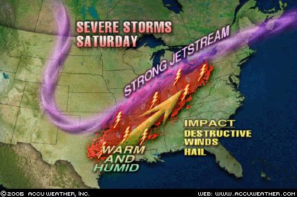
A soaking inch-plus rain will extend from the Dakotas to the western Great Lakes. Thunderstorms will be ongoing or developing from the eastern sections of the central Plains, across the mid-Mississippi Valley, to the Ohio Valley. With a strong energetic jet stream from Kansas to Lower Michigan, warming temperatures and a plentiful return of moisture from the Gulf, severe thunderstorms with hail, damaging wind gusts and tornadoes will erupt over Iowa, Missouri and Illinois Friday. Winds will be strong and gusty over the northern Plains, Mississippi Valley, western Great Lakes and Ohio Valley.
Tuesday, September 19, 2006
September 16-17, 2006 Forecast Results
Click here for September 2006 Hurricane and Severe Weather Outlook
Click here for the Introduction to The Weather Alternative
Forecast (prepared December 2005)
Sept. 16-17:
A potential tropical disturbance may get its act together over Cuba and Florida. A low pressure system will develop over the Front Range of the Rockies.
Results
A potential tropical disturbance may get its act together over Cuba and Florida.
Sept 16, 2006- Accuweather
A lingering frontal boundary across the southern peninsula of Florida will yield a few showers and thunderstorms, but at least there are no tropical systems to worry about.
A low pressure system will develop over the Front Range of the Rockies.
 Sept 16, 2006- Accuweather
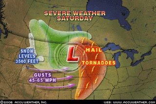
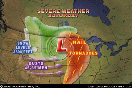
A strong storm system will dive into the northern Plains today setting the stage for a wide variety of weather… thunderstorms will become severe today with hail and even isolated tornadoes battering eastern Nebraska, western Iowa and northward into the eastern Dakotas and western Minnesota. This cold front will also lead to strong winds through the central Rockies today with gusts 45- to 65 mph. A few gusts past 70 mph could whip through canyons and gorges of the front range in Colorado and Wyoming.
Click here for the Introduction to The Weather Alternative
Forecast (prepared December 2005)
Sept. 16-17:
A potential tropical disturbance may get its act together over Cuba and Florida. A low pressure system will develop over the Front Range of the Rockies.
Results
A potential tropical disturbance may get its act together over Cuba and Florida.
Sept 16, 2006- Accuweather
A lingering frontal boundary across the southern peninsula of Florida will yield a few showers and thunderstorms, but at least there are no tropical systems to worry about.
A low pressure system will develop over the Front Range of the Rockies.
 Sept 16, 2006- Accuweather
A strong storm system will dive into the northern Plains today setting the stage for a wide variety of weather… thunderstorms will become severe today with hail and even isolated tornadoes battering eastern Nebraska, western Iowa and northward into the eastern Dakotas and western Minnesota. This cold front will also lead to strong winds through the central Rockies today with gusts 45- to 65 mph. A few gusts past 70 mph could whip through canyons and gorges of the front range in Colorado and Wyoming.
Monday, September 18, 2006
September 14-16, 2006 Forecast Results
Click here for September 2006 Hurricane and Severe Weather Outlook
Click here for the Introduction to The Weather Alternative
Most of these forecasts were prepared in December 2005.
Forecast
Sept. 14-16:
Tropical activity is shown for the area in and around Puerto Rico. Meanwhile, a new cold front hits the West Coast States dropping temperatures and increasing moisture.The Mississippi Valley and eastward will be the focal point for windy and stormy conditions.
Results
Tropical activity is shown for the area in and around Puerto Rico. (66 West/18 North)
Sept 14, 2006- NWS
TROPICAL WAVE IS ALONG 64W/65W S OF 18N MOVING W 15 KT...SCATTERED MODERATE/ISOLATED STRONG CONVECTION IS FROM 14N18N BETWEEN 63W-66W.
Meanwhile, a new cold front hits the West Coast States dropping temperatures and increasing moisture.
Sept 14, 2006- The Weather Channel
West
A significant upper level disturbance will move into the Northwest today, in the wake of a cold front that passed through yesterday. With this disturbance in the area, and much cooler air moving in, scattered showers will develop during the afternoon hours.
Sept 15, 2006- The Weather Channel
West
The unusually intense storm and early season cold snap will continue to work its way across the West this weekend on its way to engulf most of the nation.
The Mississippi Valley and eastward will be the focal point for windy and stormy conditions.
Sept 15, 2006- The Weather Channel
A giant early season storm with hints of the winter to come will take control of the north-central U.S. this weekend. A strong cold front will kick off this fast-forward to late fall as it plows eastward from the Plains to the Appalachians over the next 3 days.
Severe thunderstorms with hail, damaging winds and a few tornadoes will develop Saturday from the eastern Dakotas, Minnesota and western Wisconsin to eastern Kansas and Missouri. Some severe thunderstorms will continue across Illinois and Missouri on Sunday. As the front reaches Michigan and the Ohio Valley Monday, the thunderstorms will shift eastward across the remainder of the Midwest.
While strong warm southerly winds have gusted in advance of the front, equally strong northerly and northwesterly winds will further enhance the cold over the Plains and Midwest once the front moves through.
Click here for the Introduction to The Weather Alternative
Most of these forecasts were prepared in December 2005.
Forecast
Sept. 14-16:
Tropical activity is shown for the area in and around Puerto Rico. Meanwhile, a new cold front hits the West Coast States dropping temperatures and increasing moisture.The Mississippi Valley and eastward will be the focal point for windy and stormy conditions.
Results
Tropical activity is shown for the area in and around Puerto Rico. (66 West/18 North)
Sept 14, 2006- NWS
TROPICAL WAVE IS ALONG 64W/65W S OF 18N MOVING W 15 KT...SCATTERED MODERATE/ISOLATED STRONG CONVECTION IS FROM 14N18N BETWEEN 63W-66W.
Meanwhile, a new cold front hits the West Coast States dropping temperatures and increasing moisture.
Sept 14, 2006- The Weather Channel
West
A significant upper level disturbance will move into the Northwest today, in the wake of a cold front that passed through yesterday. With this disturbance in the area, and much cooler air moving in, scattered showers will develop during the afternoon hours.
Sept 15, 2006- The Weather Channel
West
The unusually intense storm and early season cold snap will continue to work its way across the West this weekend on its way to engulf most of the nation.
The Mississippi Valley and eastward will be the focal point for windy and stormy conditions.
Sept 15, 2006- The Weather Channel
A giant early season storm with hints of the winter to come will take control of the north-central U.S. this weekend. A strong cold front will kick off this fast-forward to late fall as it plows eastward from the Plains to the Appalachians over the next 3 days.
Severe thunderstorms with hail, damaging winds and a few tornadoes will develop Saturday from the eastern Dakotas, Minnesota and western Wisconsin to eastern Kansas and Missouri. Some severe thunderstorms will continue across Illinois and Missouri on Sunday. As the front reaches Michigan and the Ohio Valley Monday, the thunderstorms will shift eastward across the remainder of the Midwest.
While strong warm southerly winds have gusted in advance of the front, equally strong northerly and northwesterly winds will further enhance the cold over the Plains and Midwest once the front moves through.
Thursday, September 14, 2006
September 12-14 Forecast Results
Click here for September 2006 Hurricane and Severe Weather Outlook
Click here for the Introduction to The Weather Alternative
Forecast:
Most of these forecasts were prepared in December 2005.
Sept. 12-14:
Gusty winds hit the Plains, and storms affect the Mid-Atlantic, Northeast and New England. These storms over the eastern U.S. should bring abundant moisture and cause flooding problems. The culprit may be a tropical system drawn up over North Carolina or Virginia.Moisture increases over the southern California area. A front triggers showers and storms over the Rockies.Heavy rain is indicated for the island of Hispañola, which may be due to some type of tropical system.
Results
Gusty winds hit the Plains...
Sept 14, 2006- The Weather Channel
Windy conditions will develop over the central and high Plains in response to a low pressure moving toward that area.
...and storms affect the Mid-Atlantic, Northeast and New England. These storms over the eastern U.S. should bring abundant moisture and cause flooding problems. The culprit may be a tropical system drawn up over North Carolina or Virginia.
Sept 12, 2006- Accuweather
As this storm heads east, a wave of low pressure is forecast to develop along the front as it moves across Georgia late on Wednesday. That will enhance rainfall across the Carolinas and southeastern Virginia. The ground in this area remains saturated from heavy rainfall from Tropical Storm Ernesto, and there is some concern that localized flooding could occur in this area Thursday.
Sept 14, 2006- The Weather Channel
Northeast
An area of low pressure will spread rain across the Middle Atlantic into the Northeastern States today, some of which could be heavy at times.
Moisture increases over the southern California area.

Sept 14, 2006- Accuweather
Along the coastline, a thickening marine layer will prolong the low clouds, fog and drizzle along the coastline of California.
A front triggers showers and storms over the Rockies.
Sept 14, 2006- National Weather Service
THIS HAZARDOUS WEATHER OUTLOOK IS FOR WESTERN AND CENTRAL WYOMING
..DAY ONE...TODAY AND TONIGHT STRONG AND GUSTY WEST TO SOUTHWEST WINDS OF 20 TO 35 MPH ARE EXPECTED ACROSS WESTERN AND CENTRAL WYOMING THROUGH THIS EVENING AS A POWERFUL STORM SYSTEM CONTINUES TO DEVELOP OVER THE PACIFIC NORTHWEST.
AHEAD OF THIS SYSTEM THUNDERSTORMS WILL BE ON THE INCREASE THROUGH THE EVENING HOURS...ESPECIALLY ACROSS SOUTHWEST WYOMING. SOME OF THESE STORMS COULD PRODUCE WIND GUSTS TO 50 MPH...SMALL HAIL...BRIEF HEAVY RAIN AND DANGEROUS CLOUD TO GROUND LIGHTNING. A LIGHT ACCUMULATION OF SNOW IS POSSIBLE ABOVE 9000 TO 10000 FEET.
Heavy rain is indicated for the island of Hispañola, which may be due to some type of tropical system.
Click here for the Introduction to The Weather Alternative
Forecast:
Most of these forecasts were prepared in December 2005.
Sept. 12-14:
Gusty winds hit the Plains, and storms affect the Mid-Atlantic, Northeast and New England. These storms over the eastern U.S. should bring abundant moisture and cause flooding problems. The culprit may be a tropical system drawn up over North Carolina or Virginia.Moisture increases over the southern California area. A front triggers showers and storms over the Rockies.Heavy rain is indicated for the island of Hispañola, which may be due to some type of tropical system.
Results
Gusty winds hit the Plains...
Sept 14, 2006- The Weather Channel
Windy conditions will develop over the central and high Plains in response to a low pressure moving toward that area.
...and storms affect the Mid-Atlantic, Northeast and New England. These storms over the eastern U.S. should bring abundant moisture and cause flooding problems. The culprit may be a tropical system drawn up over North Carolina or Virginia.
Sept 12, 2006- Accuweather
As this storm heads east, a wave of low pressure is forecast to develop along the front as it moves across Georgia late on Wednesday. That will enhance rainfall across the Carolinas and southeastern Virginia. The ground in this area remains saturated from heavy rainfall from Tropical Storm Ernesto, and there is some concern that localized flooding could occur in this area Thursday.
Sept 14, 2006- The Weather Channel
Northeast
An area of low pressure will spread rain across the Middle Atlantic into the Northeastern States today, some of which could be heavy at times.
Moisture increases over the southern California area.

Sept 14, 2006- Accuweather
Along the coastline, a thickening marine layer will prolong the low clouds, fog and drizzle along the coastline of California.
A front triggers showers and storms over the Rockies.
Sept 14, 2006- National Weather Service
THIS HAZARDOUS WEATHER OUTLOOK IS FOR WESTERN AND CENTRAL WYOMING
..DAY ONE...TODAY AND TONIGHT STRONG AND GUSTY WEST TO SOUTHWEST WINDS OF 20 TO 35 MPH ARE EXPECTED ACROSS WESTERN AND CENTRAL WYOMING THROUGH THIS EVENING AS A POWERFUL STORM SYSTEM CONTINUES TO DEVELOP OVER THE PACIFIC NORTHWEST.
AHEAD OF THIS SYSTEM THUNDERSTORMS WILL BE ON THE INCREASE THROUGH THE EVENING HOURS...ESPECIALLY ACROSS SOUTHWEST WYOMING. SOME OF THESE STORMS COULD PRODUCE WIND GUSTS TO 50 MPH...SMALL HAIL...BRIEF HEAVY RAIN AND DANGEROUS CLOUD TO GROUND LIGHTNING. A LIGHT ACCUMULATION OF SNOW IS POSSIBLE ABOVE 9000 TO 10000 FEET.
Heavy rain is indicated for the island of Hispañola, which may be due to some type of tropical system.
Sept 14, 2006- Dominican Republic Weather Service
A tropical wave is located over the Mona Passage moving westward at 26 kph. A mid to upper level low is in the troposhpere over the island.
Saturday, September 09, 2006
Stormy West Coast and Plains
Click here for September 2006 Hurricane and Severe Weather Outlook.
Click here for the Introduction to The Weather Alternative
The Weather Alternative long-range forecast for Sept 8-9, 2006 called for a stormy period for the U.S. West Coast and Plains. These forecasts were prepared during December 2005.
The Plains
Here are the latest reports from Accuweather .com:
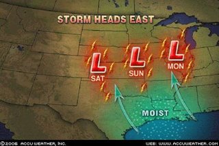 A storm system will take shape today across the west-central Plains and then head northeastward into Illinois by Monday. This storm will tap into moist Gulf of Mexico air, allowing for rain and thunderstorms to spread on eastward with it. In the area just south of the warm front and east of the cold front, enough instability will be around along with favorable jet steam energy to allow for a few storms to be locally severe with gusty winds and hail. The best threat for a severe storm today will be in western Oklahoma and the Texas Panhandle. By tomorrow, the threat will shift into central and eastern Kansas into Missouri, and by Monday into parts of southern Illinois.
The West Coast
Click here for the Introduction to The Weather Alternative
The Weather Alternative long-range forecast for Sept 8-9, 2006 called for a stormy period for the U.S. West Coast and Plains. These forecasts were prepared during December 2005.
The Plains
Here are the latest reports from Accuweather .com:
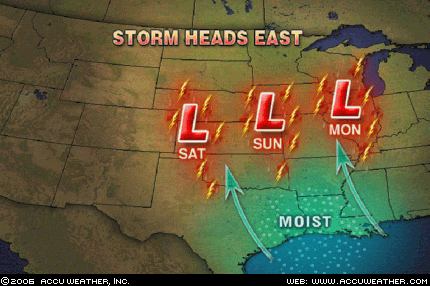 A storm system will take shape today across the west-central Plains and then head northeastward into Illinois by Monday. This storm will tap into moist Gulf of Mexico air, allowing for rain and thunderstorms to spread on eastward with it. In the area just south of the warm front and east of the cold front, enough instability will be around along with favorable jet steam energy to allow for a few storms to be locally severe with gusty winds and hail. The best threat for a severe storm today will be in western Oklahoma and the Texas Panhandle. By tomorrow, the threat will shift into central and eastern Kansas into Missouri, and by Monday into parts of southern Illinois.
The West Coast
Sept 8, 2006- Accuweather
The wildfire danger remains at a critical level in the Northwest interior. A cold front moving into the region will bring cooler temperatures and higher humidity. However, dry thunderstorms developing ahead of the front could spark more fires, and gusty winds associated with the cold front could help to spread existing fires.
A disturbance in the upper levels of the atmosphere has been causing heavy rainfall the past couple of days over the Southwest and southern Rockies.
Thursday, August 31, 2006
More Fulfilled Hurricane Predictions
Click here for September 2006 Hurricane and Severe Weather Outlook.
Click here for August 2006 Hurricane and Severe Weather Outlook.
Besides accurately predicting the time and place of Ernestos' landfall (click link), a close Weather Alternative forecast for hurricane activity over the Baja California is being fulfilled.
Hurricane John will begin to affect the Baja tomorrow. (These forecasts were prepared in December 2005)
The forecast read:
Aug. 28-30:
Tropical storm formation is possible over the central Baja Peninsula.
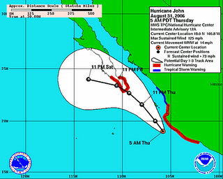 Today the Weather Channel reported:
After its close encounter with Mexico's southwest Pacific coast, John will then head towards the southern Baja Peninsula by Friday afternoon remaining as a Category 3 hurricane. A hurricane warning is in effect for the Southern Baja Peninsula from Las Pas southward on the East Coast and from Santa Fe Southward on the West Coast. This does include Cabo San Lucas. Reports are indicating that 10,000 people have been evacuated in and around the Los Cabos beach resort in preparation for John's arrival.
Hurricane Kristy is the fulfillment of another long-range forecast published in the July issue of Dell Magazine (not posted on this blog).
The forecast read:
August 30-Sept 1:
A Hurricane Hot Spot in the eastern Pacific is likely to develop near 119 West Longitude and 16 North Latitude...
The National Weather Service reported on August 30th:
TROPICAL STORM KRISTY CENTERED NEAR 16.7N 115.1W AT 30/1500 UTC MOVING NW OR 305 DEG AT 5 KT.
Click here for August 2006 Hurricane and Severe Weather Outlook.
Besides accurately predicting the time and place of Ernestos' landfall (click link), a close Weather Alternative forecast for hurricane activity over the Baja California is being fulfilled.
Hurricane John will begin to affect the Baja tomorrow. (These forecasts were prepared in December 2005)
The forecast read:
Aug. 28-30:
Tropical storm formation is possible over the central Baja Peninsula.
 Today the Weather Channel reported:
After its close encounter with Mexico's southwest Pacific coast, John will then head towards the southern Baja Peninsula by Friday afternoon remaining as a Category 3 hurricane. A hurricane warning is in effect for the Southern Baja Peninsula from Las Pas southward on the East Coast and from Santa Fe Southward on the West Coast. This does include Cabo San Lucas. Reports are indicating that 10,000 people have been evacuated in and around the Los Cabos beach resort in preparation for John's arrival.
Hurricane Kristy is the fulfillment of another long-range forecast published in the July issue of Dell Magazine (not posted on this blog).
The forecast read:
August 30-Sept 1:
A Hurricane Hot Spot in the eastern Pacific is likely to develop near 119 West Longitude and 16 North Latitude...
The National Weather Service reported on August 30th:
TROPICAL STORM KRISTY CENTERED NEAR 16.7N 115.1W AT 30/1500 UTC MOVING NW OR 305 DEG AT 5 KT.
Monday, August 28, 2006
Ernesto Fulfills Long-Range Prediction

Click here for September 2006 Hurricane and Severe Weather Outlook.
Click here for August 2006 Hurricane and Severe Weather Outlook.
The Weather Alternative Forecast for August 28-30, 2006 stated "Tropical troubles are still brewing over a broad area from western Cuba through western Florida and into Georgia and South Carolina." This forecast was prepared in December 2005 and posted on The Weather Alternative July 23, 2006.
Today Tropical Storm Ernesto is hitting southern Cuba. A Hurricane Watch has been issued for parts of mainland South Florida.
Sunday, August 27, 2006
August 19-22, 2006 Forecast Results
Click here for September 2006 Hurricane and Severe Weather Outlook.
Click here for August 2006 Hurricane and Severe Weather Outlook.
Forecast for August 19-22, 2006
These forecasts were developed during the first two weeks of December 2005.
Aug. 19-22:
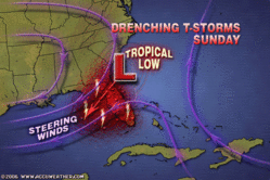
Several atmospheric ingredients will come together over the Southeastern States from the Big Bend of Florida into Georgia creating a threat of severe weather. The threat will extend into the Ohio Valley as well. It is possible that this signifies a tropical system or at least abundant tropical moisture that drops heavy rain over the Southeast.
Results
August 19, 2006- Accuweather
The cold front that triggered these storms is steadily moving east and showers and strong storms are expected later today across the Ohio Valley and into the eastern Great Lakes.
August 19, 2006- Map by Accuweather
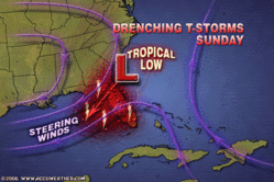
August 21, 2006- Accuweather
Drenching Southern Storms
(State College, PA) - The front that brought soaking rain to parts of the Northeast over the weekend is stalling in the South. AccuWeather.com is forecasting that showers and thunderstorms through the end of the week may lead to localized flooding problems.
Click here for August 2006 Hurricane and Severe Weather Outlook.
Forecast for August 19-22, 2006
These forecasts were developed during the first two weeks of December 2005.
Aug. 19-22:
Several atmospheric ingredients will come together over the Southeastern States from the Big Bend of Florida into Georgia creating a threat of severe weather. The threat will extend into the Ohio Valley as well. It is possible that this signifies a tropical system or at least abundant tropical moisture that drops heavy rain over the Southeast.
Results
August 19, 2006- Accuweather
The cold front that triggered these storms is steadily moving east and showers and strong storms are expected later today across the Ohio Valley and into the eastern Great Lakes.
August 19, 2006- Map by Accuweather
August 21, 2006- Accuweather
Drenching Southern Storms
(State College, PA) - The front that brought soaking rain to parts of the Northeast over the weekend is stalling in the South. AccuWeather.com is forecasting that showers and thunderstorms through the end of the week may lead to localized flooding problems.
August 16-18, 2006 Forecast Results
Click here for September 2006 Hurricane and Severe Weather Outlook.
Click here for August 2006 Hurricane and Severe Weather Outlook.
Forecast for August 16-18, 2006
These forecasts were developed during the first two weeks of December 2005.
Aug. 16-18:
A strong storm system is indicated over New England and the Canadian Maritimes as energy moving from the west interacts with a warm, moist air mass.
Results
Aug 19, 2006- Weather Channel (Storms arrived a day later than my forecast period)
Northeast
High pressure moving to the east will allow a storm system to approach from the west. Numerous showers and thunderstorms will spread across western New England and the Upper Ohio Valley today, along with the potential for an isolated severe thunderstorm or two, as well as heavy downpours and localized flooding.
Click here for August 2006 Hurricane and Severe Weather Outlook.
Forecast for August 16-18, 2006
These forecasts were developed during the first two weeks of December 2005.
Aug. 16-18:
A strong storm system is indicated over New England and the Canadian Maritimes as energy moving from the west interacts with a warm, moist air mass.
Results
Aug 19, 2006- Weather Channel (Storms arrived a day later than my forecast period)
Northeast
High pressure moving to the east will allow a storm system to approach from the west. Numerous showers and thunderstorms will spread across western New England and the Upper Ohio Valley today, along with the potential for an isolated severe thunderstorm or two, as well as heavy downpours and localized flooding.
Thursday, August 24, 2006
September 2006 Hurricane and Severe Weather Outlook
Click here for August 2006 Hurricane and Severe Weather Outlook.
Most of these forecasts were prepared in December 2005.
August 30-Sept 1:
Look for increasing moisture over the southern California coast resulting in foggy conditions or rain.
Storms will be active over the Rockies.
Sept. 2-5:
A potential Hurricane Hot Spot is activated off the eastern coast of Mexico in the Gulf around the 2nd or 3rd. At the same time, a broad area encompassing the central Caribbean, Cuba, Florida, and the Carolinas may be the breeding grounds for more tropical activity.
Sept. 3-5:
Changes are also underway for the West Coast States and the Rockies. Look for lower temperatures and windy conditions there. The New England area should expect strong storms that head to the Canadian Maritimes.
A tropical disturbance may flare up over the Bahamas.
Sept. 5-7:
More moisture is drawn up over southern California resulting in an increased chance of showers and thunder storms.
The Rockies warm up as winds from the south increase temperatures and precipitation.
Texas and the Plains at this time will deal with unseasonable heat that cranks up the storm machine over the area.
Sept 6-8:
Tropical troubles may be brewing for the island of Hispañola and surrounding areas.
The US East Coast will attract a tropical flow over Virginia and northward through the eastern Great Lakes. If not an actual tropical system, strong storms will drop heavy rain with the potential for flash flooding and bring windy conditions.
Sept. 8-9:
A stormy period continues for the U.S. West Coast and the Plains.
Sept. 12-14:
Gusty winds hit the Plains, and storms affect the Mid-Atlantic, Northeast and New England. These storms over the eastern U.S. should bring abundant moisture and cause flooding problems. The culprit may be a tropical system drawn up over North Carolina or Virginia.
Moisture increases over the southern California area. A front triggers showers and storms over the Rockies.
Heavy rain is indicated for the island of Hispañola, which may be due to some type of tropical system.
Sept. 14-16:
Tropical activity is shown for the area in and around Puerto Rico. Meanwhile, a new cold front hits the West Coast States dropping temperatures and increasing moisture.
The Mississippi Valley and eastward will be the focal point for windy and stormy conditions.
Sept. 16-17:
A potential tropical disturbance may get its act together over Cuba and Florida. A low pressure system will develop over the Front Range of the Rockies.
Sept 19-21:
Storm potential is shown for the island of Hispañola and the Mid-Atlantic through the Northeast.
Sept 20-22:
Heavy downpours are shown over the Florida Peninsula and western Cuba.
Sept. 21-23:
The U.S. West Coast shows severe weather in the form of extreme temperature changes and/or storms.
The insurgence of warm, moist air over the Gulf Coast States from Texas to Florida will act as a potential storm breeder on its journey northward into the central U.S.
Severe storms will break out over the Mid-Atlantic States and Northeast.
Sept. 23-25:
A tropical weather system may be brewing near the Dominican Republic and tropical moisture unloads over the Florida Panhandle.
Sept. 24-26:
A blast of cold air will assault the Mid-Atlantic and Southeast generating gusty winds and slashing temperatures.
A new Hurricane Hot Spot emerges for the fall portion of the hurricane season off the coast of Africa. The formation of a significant tropical system is possible now along the African West Coast around 18 West Longitude and 18 North Latitude, which should move westward toward 31 West-16 North.
Another danger spot is shown along the eastern Central American coast of Belize, Guatemala, and Honduras.
Noteworthy weather events are in store for the U.S. West Coast bringing abnormally wet conditions. Such will be the case for coastal California especially around the 26th when an influx of tropical moisture is drawn northward over the State from southern regions. The western Plains carry the potential for excessive humidity and abnormal rainfall to dominate now and move eastward through the Mississippi Valley.
Sept 26-28:
The potential for heavy rainfall is shown over the eastern US from the eastern Great Lakes southward to Virginia. Storms are indicated for the Plains.
Sept. 28-30:
The Central Gulf of Mexico may spawn a tropical disturbance that is drawn up over the Mississippi-Alabama costal area and into the Deep South. If not an actual tropical system, at the least tropical moisture should be funneled into the area from the Gulf. Rain is indicated over the Florida Peninsula. Low pressure may form off the Baja sending moisture over southern California.
Sept. 29-Oct. 1:
A tropical system may be indicated between Puerto Rico and the Lesser Antilles now.
Most of these forecasts were prepared in December 2005.
August 30-Sept 1:
Look for increasing moisture over the southern California coast resulting in foggy conditions or rain.
Storms will be active over the Rockies.
Sept. 2-5:
A potential Hurricane Hot Spot is activated off the eastern coast of Mexico in the Gulf around the 2nd or 3rd. At the same time, a broad area encompassing the central Caribbean, Cuba, Florida, and the Carolinas may be the breeding grounds for more tropical activity.
Sept. 3-5:
Changes are also underway for the West Coast States and the Rockies. Look for lower temperatures and windy conditions there. The New England area should expect strong storms that head to the Canadian Maritimes.
A tropical disturbance may flare up over the Bahamas.
Sept. 5-7:
More moisture is drawn up over southern California resulting in an increased chance of showers and thunder storms.
The Rockies warm up as winds from the south increase temperatures and precipitation.
Texas and the Plains at this time will deal with unseasonable heat that cranks up the storm machine over the area.
Sept 6-8:
Tropical troubles may be brewing for the island of Hispañola and surrounding areas.
The US East Coast will attract a tropical flow over Virginia and northward through the eastern Great Lakes. If not an actual tropical system, strong storms will drop heavy rain with the potential for flash flooding and bring windy conditions.
Sept. 8-9:
A stormy period continues for the U.S. West Coast and the Plains.
Sept. 12-14:
Gusty winds hit the Plains, and storms affect the Mid-Atlantic, Northeast and New England. These storms over the eastern U.S. should bring abundant moisture and cause flooding problems. The culprit may be a tropical system drawn up over North Carolina or Virginia.
Moisture increases over the southern California area. A front triggers showers and storms over the Rockies.
Heavy rain is indicated for the island of Hispañola, which may be due to some type of tropical system.
Sept. 14-16:
Tropical activity is shown for the area in and around Puerto Rico. Meanwhile, a new cold front hits the West Coast States dropping temperatures and increasing moisture.
The Mississippi Valley and eastward will be the focal point for windy and stormy conditions.
Sept. 16-17:
A potential tropical disturbance may get its act together over Cuba and Florida. A low pressure system will develop over the Front Range of the Rockies.
Sept 19-21:
Storm potential is shown for the island of Hispañola and the Mid-Atlantic through the Northeast.
Sept 20-22:
Heavy downpours are shown over the Florida Peninsula and western Cuba.
Sept. 21-23:
The U.S. West Coast shows severe weather in the form of extreme temperature changes and/or storms.
The insurgence of warm, moist air over the Gulf Coast States from Texas to Florida will act as a potential storm breeder on its journey northward into the central U.S.
Severe storms will break out over the Mid-Atlantic States and Northeast.
Sept. 23-25:
A tropical weather system may be brewing near the Dominican Republic and tropical moisture unloads over the Florida Panhandle.
Sept. 24-26:
A blast of cold air will assault the Mid-Atlantic and Southeast generating gusty winds and slashing temperatures.
A new Hurricane Hot Spot emerges for the fall portion of the hurricane season off the coast of Africa. The formation of a significant tropical system is possible now along the African West Coast around 18 West Longitude and 18 North Latitude, which should move westward toward 31 West-16 North.
Another danger spot is shown along the eastern Central American coast of Belize, Guatemala, and Honduras.
Noteworthy weather events are in store for the U.S. West Coast bringing abnormally wet conditions. Such will be the case for coastal California especially around the 26th when an influx of tropical moisture is drawn northward over the State from southern regions. The western Plains carry the potential for excessive humidity and abnormal rainfall to dominate now and move eastward through the Mississippi Valley.
Sept 26-28:
The potential for heavy rainfall is shown over the eastern US from the eastern Great Lakes southward to Virginia. Storms are indicated for the Plains.
Sept. 28-30:
The Central Gulf of Mexico may spawn a tropical disturbance that is drawn up over the Mississippi-Alabama costal area and into the Deep South. If not an actual tropical system, at the least tropical moisture should be funneled into the area from the Gulf. Rain is indicated over the Florida Peninsula. Low pressure may form off the Baja sending moisture over southern California.
Sept. 29-Oct. 1:
A tropical system may be indicated between Puerto Rico and the Lesser Antilles now.
Monday, August 21, 2006
August 14-15, 2006 Forecast Results
Click here for August 2006 Hurricane and Severe Weather Outlook.
These forecasts were developed during the first two weeks of December 2005.
Forecast
Aug 14-15:
Meteorological mayhem breaks out over the Southeast U.S. through the Ohio Valley as atmospheric elements combine over the area. One scenario shows a tropical system approaching the west coast of Florida and pushing inland with soaking rains. Another model suggests strong storms with damaging winds and flooding.
Results
August 14, 2006- The Weather Channel
A few severe storms Ohio Valley Monday
A stalled front off the coast of northeast Florida may drift slightly southward into an area of lower wind shear aloft over the next day or two. This could provide the opportunity for a tropical or subtropical low pressure system to develop somewhere along the front in the vicinity of enhanced thunderstorms over the Gulf Stream.
August 16, 2006- The Weather Channel
A flare-up of heavy showers associated with a low pressure center about 125 miles southeast of Myrtle Beach, S. C., is being monitored closely. Air force reserve Hurricane Hunters are tasked to investigate the disturbance this afternoon. It's possible a tropical depression could form later today or tonight if the convection--the heavy showers--persists. Upper-level winds are light (minimal wind shear) and the disturbance is near the Gulf Stream (plenty of warm water).
These forecasts were developed during the first two weeks of December 2005.
Forecast
Aug 14-15:
Meteorological mayhem breaks out over the Southeast U.S. through the Ohio Valley as atmospheric elements combine over the area. One scenario shows a tropical system approaching the west coast of Florida and pushing inland with soaking rains. Another model suggests strong storms with damaging winds and flooding.
Results
August 14, 2006- The Weather Channel
A few severe storms Ohio Valley Monday
A stalled front off the coast of northeast Florida may drift slightly southward into an area of lower wind shear aloft over the next day or two. This could provide the opportunity for a tropical or subtropical low pressure system to develop somewhere along the front in the vicinity of enhanced thunderstorms over the Gulf Stream.
August 16, 2006- The Weather Channel
A flare-up of heavy showers associated with a low pressure center about 125 miles southeast of Myrtle Beach, S. C., is being monitored closely. Air force reserve Hurricane Hunters are tasked to investigate the disturbance this afternoon. It's possible a tropical depression could form later today or tonight if the convection--the heavy showers--persists. Upper-level winds are light (minimal wind shear) and the disturbance is near the Gulf Stream (plenty of warm water).
Sunday, August 20, 2006
August 11-13, 2006 Forecast Results
Click here for August 2006 Hurricane and Severe Weather Outlook.
There forecasts were prepared during the first two weeks of December 2005.
Forecast
Aug. 11-13:
Gusty winds will prevail along the West Coast with storm potential further inland.
Results
August 11, 2006- Accuweather
Farther south, it will continue to be active across the Southwest, mainly in Arizona, New Mexico and Colorado, as monsoonal moisture streaming into the area will spark the development of thunderstorms. Some storms will dump heavy rains that could create a threat of flash flooding.
AREA FORECAST DISCUSSION
NATIONAL WEATHER SERVICE MEDFORD OR
858 PM PDT SAT AUG 12 2006
.DISCUSSION...LITTLE CHANGE. WEAK 500 MB TROUGH EXTENDS FROM THE NORTHERN ROCKIES TO SOUTHERN OREGON. THERMAL TROUGH OVER NORTHERN CALIFORNIA IS PULLING SOME MODERATE NORTHERLIES DOWN THE SOUTH COAST. SHOULD AGAIN SEE BREEZY OFFSHORE WINDS ACROSS THE RIDGES OF SOUTHWEST OREGON WITH MARGINAL HUMIDITY RECOVERY TONIGHT.
AREA FORECAST DISCUSSION
NATIONAL WEATHER SERVICE MEDFORD OR
315 AM PDT SUN AUG 13 2006
.DISCUSSION...ONLY A FEW CHANGES NEEDED AFTER THE EVENING SHIFT
UPDATES. ABOVE NORMAL HIGHS LOOK GOOD THIS AFTERNOON AS THERMAL TROUGH POSITION SHIFTS FROM THE SOUTHERN OREGON COAST TO NEAR THE CASCADES THIS AFTERNOON. AIR MASS IS DRY AND STABLE TODAY. WILL SEE GUSTY WINDS ALONG THE COAST WITH STRONG HIGH PRESSURE OFFSHORE AND THE THERMAL TROUGH NOT FAR INLAND.
There forecasts were prepared during the first two weeks of December 2005.
Forecast
Aug. 11-13:
Gusty winds will prevail along the West Coast with storm potential further inland.
Results
August 11, 2006- Accuweather
Farther south, it will continue to be active across the Southwest, mainly in Arizona, New Mexico and Colorado, as monsoonal moisture streaming into the area will spark the development of thunderstorms. Some storms will dump heavy rains that could create a threat of flash flooding.
AREA FORECAST DISCUSSION
NATIONAL WEATHER SERVICE MEDFORD OR
858 PM PDT SAT AUG 12 2006
.DISCUSSION...LITTLE CHANGE. WEAK 500 MB TROUGH EXTENDS FROM THE NORTHERN ROCKIES TO SOUTHERN OREGON. THERMAL TROUGH OVER NORTHERN CALIFORNIA IS PULLING SOME MODERATE NORTHERLIES DOWN THE SOUTH COAST. SHOULD AGAIN SEE BREEZY OFFSHORE WINDS ACROSS THE RIDGES OF SOUTHWEST OREGON WITH MARGINAL HUMIDITY RECOVERY TONIGHT.
AREA FORECAST DISCUSSION
NATIONAL WEATHER SERVICE MEDFORD OR
315 AM PDT SUN AUG 13 2006
.DISCUSSION...ONLY A FEW CHANGES NEEDED AFTER THE EVENING SHIFT
UPDATES. ABOVE NORMAL HIGHS LOOK GOOD THIS AFTERNOON AS THERMAL TROUGH POSITION SHIFTS FROM THE SOUTHERN OREGON COAST TO NEAR THE CASCADES THIS AFTERNOON. AIR MASS IS DRY AND STABLE TODAY. WILL SEE GUSTY WINDS ALONG THE COAST WITH STRONG HIGH PRESSURE OFFSHORE AND THE THERMAL TROUGH NOT FAR INLAND.
Wednesday, August 16, 2006
August 9-12, 2006 Forecast Results
Click here for August 2006 Hurricane and Severe Weather Outlook.
These forecasts were prepared during the first two weeks of December 2005.
Forecast
Aug. 9-12:
A tropical system may get its act together over Cuba and the Bahamas. Tropical moisture from this system or elsewhere should be pulled up over the Florida Peninsula and the Carolinas. Severe storms will develop over the Ohio Valley as well. Another hot spot for hurricane development is shown off the eastern coast of Mexico in the western Gulf around 96 West Longitude and 22 North Latitude.
Results
A tropical system may get its act together over Cuba and the Bahamas. Tropical moisture from this system or elsewhere should be pulled up over the Florida Peninsula nad the Carolinas.
South Florida rain
9:25 a.m. ET 8/9/2006
Senior Meteorologist, The Weather Channel
South
A tropical wave plus a weather system aloft combined to dump pockets of heavy rain on parts of southern Florida on Tuesday (8th) and more rain is likely into Wednesday (9th). Look for some localized flooding, especially on streets.
Tropical wave eyes Florida
5:55 a.m. ET 8/9/06
Matthew Newman, Sr. Meteorologist, The Weather Channel
A tropical wave over the Bahamas is interacting with an upper low near southern Florida may produce pockets of heavy rain for southern Florida.
August 11, 2006- The Weather Channel
One area to watch however will be off the eastern Carolinas where a front is expected to stall. While unlikely, stalled fronts in these areas can sometimes generate areas of low pressure.
Severe storms will develop over the Ohio Valley as well.
August 10, 2006- Accuweather
Before the drier air pushes into the Ohio Valley, a strong disturbance moving through the Plains and western Midwest states will spark another round of severe thunderstorms across these areas today…By Saturday (12th), the Ohio Valley will be rid of the storms…
Another Hurricane Hot Spot is shown off the eastern coast of Mexico in the western Gulf around 96 West Longitude and 22 North Latitude.
August 11, 2006- NWS
...DISCUSSION...
GULF OF MEXICO...
THE UPPER LEVEL LOW REMAINS IN THE W GULF NEAR 25N95W COVERING
THE AREA W OF 86W…
August 11, 2006- Mexican Weather Bureau
Vaguada en el Golfo de México
Del 11 al 16 de agosto
El sistema se encuentra en el Norte del Golfo de México, avanzará hacia el Oeste y se espera que alcance la costa de Tamaulipas a partir del día 11. Entrará a tierra el día 12, originando una amplia zona de inestabilidad, misma que estará asociada a tiempo severo en el Noreste de México.
A rough translation of the above states that a low pressure system in the northern Gulf of Mexico will move toward the West affecting the coast of Tamaulipas on the 11th. The low pressure system will then be over land on the 12th bringing an unstable air mass, which will be associated with severe weather in the northeast of Mexico.
These forecasts were prepared during the first two weeks of December 2005.
Forecast
Aug. 9-12:
A tropical system may get its act together over Cuba and the Bahamas. Tropical moisture from this system or elsewhere should be pulled up over the Florida Peninsula and the Carolinas. Severe storms will develop over the Ohio Valley as well. Another hot spot for hurricane development is shown off the eastern coast of Mexico in the western Gulf around 96 West Longitude and 22 North Latitude.
Results
A tropical system may get its act together over Cuba and the Bahamas. Tropical moisture from this system or elsewhere should be pulled up over the Florida Peninsula nad the Carolinas.
South Florida rain
9:25 a.m. ET 8/9/2006
Senior Meteorologist, The Weather Channel
South
A tropical wave plus a weather system aloft combined to dump pockets of heavy rain on parts of southern Florida on Tuesday (8th) and more rain is likely into Wednesday (9th). Look for some localized flooding, especially on streets.
Tropical wave eyes Florida
5:55 a.m. ET 8/9/06
Matthew Newman, Sr. Meteorologist, The Weather Channel
A tropical wave over the Bahamas is interacting with an upper low near southern Florida may produce pockets of heavy rain for southern Florida.
August 11, 2006- The Weather Channel
One area to watch however will be off the eastern Carolinas where a front is expected to stall. While unlikely, stalled fronts in these areas can sometimes generate areas of low pressure.
Severe storms will develop over the Ohio Valley as well.
August 10, 2006- Accuweather
Before the drier air pushes into the Ohio Valley, a strong disturbance moving through the Plains and western Midwest states will spark another round of severe thunderstorms across these areas today…By Saturday (12th), the Ohio Valley will be rid of the storms…
Another Hurricane Hot Spot is shown off the eastern coast of Mexico in the western Gulf around 96 West Longitude and 22 North Latitude.
August 11, 2006- NWS
...DISCUSSION...
GULF OF MEXICO...
THE UPPER LEVEL LOW REMAINS IN THE W GULF NEAR 25N95W COVERING
THE AREA W OF 86W…
August 11, 2006- Mexican Weather Bureau
Vaguada en el Golfo de México
Del 11 al 16 de agosto
El sistema se encuentra en el Norte del Golfo de México, avanzará hacia el Oeste y se espera que alcance la costa de Tamaulipas a partir del día 11. Entrará a tierra el día 12, originando una amplia zona de inestabilidad, misma que estará asociada a tiempo severo en el Noreste de México.
A rough translation of the above states that a low pressure system in the northern Gulf of Mexico will move toward the West affecting the coast of Tamaulipas on the 11th. The low pressure system will then be over land on the 12th bringing an unstable air mass, which will be associated with severe weather in the northeast of Mexico.
Monday, August 07, 2006
August 6-7, 2006 Forecast Results
Click here for August 2006 Hurricane and Severe Weather Outlook.
This forecast was developed during the first two weeks of December 2005.
Forecast
Aug. 6-7:
The coastal areas from Virginia and North Carolina through New England are in for some severe weather in the form of storms producing wind and rain.
Results
August 6, 2006-Accuweather

The Northeast is primed for strong to severe thunderstorms Monday...Storms will produce heavy downpours, damaging winds and large hail, with an isolated tornado possible.
August 7, 2006- The Weather Channel
Northeast
Scattered showers and thunderstorms, some severe, will gallop through the Northeast today in advance of a Canadian cold front. Gusty winds will prevail as the front approaches, and winds in some of the storms could be quite strong.
August 7, 2006- National Weather Service
BULLETIN - IMMEDIATE BROADCAST REQUESTEDSPECIAL MARINE WARNING
NATIONAL WEATHER SERVICE
WAKEFIELD VA629 AM EDT MON AUG 7 2006
THE NATIONAL WEATHER SERVICE IN WAKEFIELD HAS ISSUED A* SPECIAL MARINE WARNING FOR... CHESAPEAKE BAY FROM WINDMILL POINT TO NEW POINT COMFORT VA CHESAPEAKE BAY FROM SMITH POINT TO WINDMILL POINT VA
SPECIAL WEATHER STATEMENT
NATIONAL WEATHER SERVICE
WAKEFIELD VA851 AM EDT MON AUG 7 2006
ACCOMACK VA-INLAND WORCESTER MD-MARYLAND BEACHES MD-NORTHAMPTON VA-851 AM EDT MON AUG 7 2006
...THUNDERSTORMS MOVING THROUGH THE EASTERN SHORE...
This forecast was developed during the first two weeks of December 2005.
Forecast
Aug. 6-7:
The coastal areas from Virginia and North Carolina through New England are in for some severe weather in the form of storms producing wind and rain.
Results
August 6, 2006-Accuweather
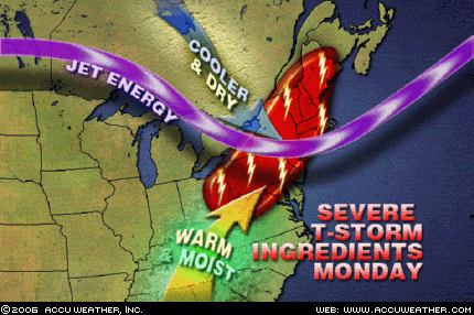
The Northeast is primed for strong to severe thunderstorms Monday...Storms will produce heavy downpours, damaging winds and large hail, with an isolated tornado possible.
August 7, 2006- The Weather Channel
Northeast
Scattered showers and thunderstorms, some severe, will gallop through the Northeast today in advance of a Canadian cold front. Gusty winds will prevail as the front approaches, and winds in some of the storms could be quite strong.
August 7, 2006- National Weather Service
BULLETIN - IMMEDIATE BROADCAST REQUESTEDSPECIAL MARINE WARNING
NATIONAL WEATHER SERVICE
WAKEFIELD VA629 AM EDT MON AUG 7 2006
THE NATIONAL WEATHER SERVICE IN WAKEFIELD HAS ISSUED A* SPECIAL MARINE WARNING FOR... CHESAPEAKE BAY FROM WINDMILL POINT TO NEW POINT COMFORT VA CHESAPEAKE BAY FROM SMITH POINT TO WINDMILL POINT VA
SPECIAL WEATHER STATEMENT
NATIONAL WEATHER SERVICE
WAKEFIELD VA851 AM EDT MON AUG 7 2006
ACCOMACK VA-INLAND WORCESTER MD-MARYLAND BEACHES MD-NORTHAMPTON VA-851 AM EDT MON AUG 7 2006
...THUNDERSTORMS MOVING THROUGH THE EASTERN SHORE...
Thursday, August 03, 2006
July 31-August 2 Forecast Results
Click here for August 2006 Hurricane and Severe Weather Outlook.
These forecasts were calculated between November 16, 2005 and November 28, 2005.
July 31-August 2 Forecast:
Tropical storm or hurricane development is now likely east of the Lesser Antilles. New England is also slated for more severe weather now.
Results (Bold text, mine)
Tropical storm of hurricane development is now likely east of the Lesser Antilles.
August 1, 2006:
By AccuWeather.com News Director Steve Penstone
(State College, PA) - As residents of Florida join millions of Americans trying to beat the searing heat, they are also keeping a wary eye on the third named tropical system of the 2006 Atlantic hurricane season. Tropical Storm Chris formed early this morning east of the Leeward Islands. As of 1 p.m. EDT, the storm was located approximately 65 miles east-northeast of Antigua, moving west-northwest at about 10 mph. Chris has maximum sustained winds of 40 mph with higher gusts.
New Enlgand is also slated for more severe weather now.
August 2, 2006- Accuweather
Drenching thunderstorms will be a concern again today across New England and from Michigan to the Central Plains States as a cold front slices into the sizzling air mass over the East.
The daytime heating also sparked outbreaks of severe weather in eastern Canada and New England. A powerful thunderstorm in Quebec last evening left one man dead and 400 thousand Hydro Quebec customers without power. Canada Press reports a motorist was killed by a falling tree branch as the storm ripped through Montreal. Winds gusted to close to 100 km/h (60 mph). The storms also tore through New England, downing trees in New Hampshire and Maine.
These forecasts were calculated between November 16, 2005 and November 28, 2005.
July 31-August 2 Forecast:
Tropical storm or hurricane development is now likely east of the Lesser Antilles. New England is also slated for more severe weather now.
Results (Bold text, mine)
Tropical storm of hurricane development is now likely east of the Lesser Antilles.
August 1, 2006:
By AccuWeather.com News Director Steve Penstone
(State College, PA) - As residents of Florida join millions of Americans trying to beat the searing heat, they are also keeping a wary eye on the third named tropical system of the 2006 Atlantic hurricane season. Tropical Storm Chris formed early this morning east of the Leeward Islands. As of 1 p.m. EDT, the storm was located approximately 65 miles east-northeast of Antigua, moving west-northwest at about 10 mph. Chris has maximum sustained winds of 40 mph with higher gusts.
New Enlgand is also slated for more severe weather now.
August 2, 2006- Accuweather
Drenching thunderstorms will be a concern again today across New England and from Michigan to the Central Plains States as a cold front slices into the sizzling air mass over the East.
The daytime heating also sparked outbreaks of severe weather in eastern Canada and New England. A powerful thunderstorm in Quebec last evening left one man dead and 400 thousand Hydro Quebec customers without power. Canada Press reports a motorist was killed by a falling tree branch as the storm ripped through Montreal. Winds gusted to close to 100 km/h (60 mph). The storms also tore through New England, downing trees in New Hampshire and Maine.
Sunday, July 30, 2006
July 27-30, 2006 Forecast Results
Click here for August 2006 Hurricane and Severe Weather Outlook.
Click here for July 2006 Hurricane and Severe Weather Outlook.
These forecasts were calculated between November 16, 2005 and November 28, 2005.
Forecast:
July 27-30: The inhabitants of the western coast of Mexico around the States of Chihuahua, Michoacan, Jalisco, and Nayarit should prepare for tropical storm development.
It seems the East Coast will be the focal point for severe weather as well. It may be a tropical system affecting the Carolinas and northward. The Upper Mississippi Valley also stands out in regards to strong winds.
Results
The inhabitants of the western coast of Mexico around the States of Chihuahua, Michoacan, Jalisco, and Nayarit should prepare for tropical storm development.
July 27, 2006- Mexican Weather Bureau
Áreas con potencial de tormentas (viento y fenómenos hidrometeorológicos de corta duración):
Intensas: Baja California Sur, Sonora, Sinaloa, Nayartit, Jalisco, Colima, Michoacán, Guerrero, Oaxaca, Chiapas, Tabasco, Hidalgo, Tamaulipas y Veracruz.
Severe thunderstorms over a number of States including Chihuahua, Michoacan, Jalisco, and Nayarit.
July 28, 2006- Mexican Weather Bureau
Lluvias intensas se esperan en Sonora y Chihuahua.
Heavy rain over Sonora and Chihuahua.
It seems the East Coast will be the focal point for severe weather as well. It may be a tropical system affecting the Carolinas and northward.
July 28, 2006- Accuweather
Heavy drenching thunderstorms today will spread across the Ohio Valley and the Northeast.
This weekend, a tropical wave will near Florida from the Caribbean. This wave will make for a breezy day along the eastern coastline of Florida, but more noticeable will be the thunderstorms. Thunderstorms that do form will bring more than your typical rainfall to parts of the Southeast as extra moisture will be injected into the storms.
July 30, 2006- The Weather Channel
South
Deep moisture in place, combined with daytime heating, and a weak disturbance in the atmosphere, will produce scattered showers and thunderstorms across parts of the southeast today. The best opportunities to see these showers and thunderstorms will exist across central and southern Mississippi, southern Alabama and Georgia, and the coastal Carolinas and Florida. Here the sea breeze will interact with boundaries left from storms yesterday to produce brief periods of heavy downpours and gusty winds with a few of the thunderstorms.
The Upper Mississippi Valley also stands out in regards to strong winds.
July 28, 2006- Accuweather
On Thursday, numerous thunderstorms ignited in the juicy air mass blanketing the eastern half of the nation. A frontal boundary across the southern Great Lakes enhanced the development of numerous storms with gusty winds, hail and drenching downpours. Strong thunderstorms knocked out power in the Chicagoland area and caused delays at O'Hare and Midway airports.
July 30, 2006- Accuweather

Before the heat spreads over the entire Great Lakes on Monday, the region will have to endure an active weather day, as a frontal boundary has triggered and will continue to trigger severe thunderstorms. As the hot air to the south interacts with the somewhat cooler air to the north, thunderstorms with damaging winds, hail and torrential downpours will erupt.
Click here for July 2006 Hurricane and Severe Weather Outlook.
These forecasts were calculated between November 16, 2005 and November 28, 2005.
Forecast:
July 27-30: The inhabitants of the western coast of Mexico around the States of Chihuahua, Michoacan, Jalisco, and Nayarit should prepare for tropical storm development.
It seems the East Coast will be the focal point for severe weather as well. It may be a tropical system affecting the Carolinas and northward. The Upper Mississippi Valley also stands out in regards to strong winds.
Results
The inhabitants of the western coast of Mexico around the States of Chihuahua, Michoacan, Jalisco, and Nayarit should prepare for tropical storm development.
July 27, 2006- Mexican Weather Bureau
Áreas con potencial de tormentas (viento y fenómenos hidrometeorológicos de corta duración):
Intensas: Baja California Sur, Sonora, Sinaloa, Nayartit, Jalisco, Colima, Michoacán, Guerrero, Oaxaca, Chiapas, Tabasco, Hidalgo, Tamaulipas y Veracruz.
Severe thunderstorms over a number of States including Chihuahua, Michoacan, Jalisco, and Nayarit.
July 28, 2006- Mexican Weather Bureau
Lluvias intensas se esperan en Sonora y Chihuahua.
Heavy rain over Sonora and Chihuahua.
It seems the East Coast will be the focal point for severe weather as well. It may be a tropical system affecting the Carolinas and northward.
July 28, 2006- Accuweather
Heavy drenching thunderstorms today will spread across the Ohio Valley and the Northeast.
This weekend, a tropical wave will near Florida from the Caribbean. This wave will make for a breezy day along the eastern coastline of Florida, but more noticeable will be the thunderstorms. Thunderstorms that do form will bring more than your typical rainfall to parts of the Southeast as extra moisture will be injected into the storms.
July 30, 2006- The Weather Channel
South
Deep moisture in place, combined with daytime heating, and a weak disturbance in the atmosphere, will produce scattered showers and thunderstorms across parts of the southeast today. The best opportunities to see these showers and thunderstorms will exist across central and southern Mississippi, southern Alabama and Georgia, and the coastal Carolinas and Florida. Here the sea breeze will interact with boundaries left from storms yesterday to produce brief periods of heavy downpours and gusty winds with a few of the thunderstorms.
The Upper Mississippi Valley also stands out in regards to strong winds.
July 28, 2006- Accuweather
On Thursday, numerous thunderstorms ignited in the juicy air mass blanketing the eastern half of the nation. A frontal boundary across the southern Great Lakes enhanced the development of numerous storms with gusty winds, hail and drenching downpours. Strong thunderstorms knocked out power in the Chicagoland area and caused delays at O'Hare and Midway airports.
July 30, 2006- Accuweather
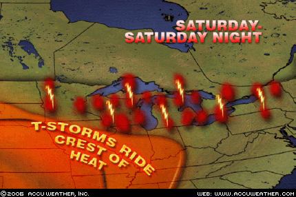
Before the heat spreads over the entire Great Lakes on Monday, the region will have to endure an active weather day, as a frontal boundary has triggered and will continue to trigger severe thunderstorms. As the hot air to the south interacts with the somewhat cooler air to the north, thunderstorms with damaging winds, hail and torrential downpours will erupt.
Sunday, July 23, 2006
August 2006 Hurricane and Severe Weather Outlook
Click here for July 2006 Hurricane and Severe Weather Outlook.
These forecasts were developed during the first two weeks of December 2005.
I’ve included the dates of the Moon’s maximum declination north and south of the equator as well as its equatorial crossing. I’ve noticed that many hurricanes have formed or made landfall around these dates.
Aug. 1-2:
Significant storms focus on the Northeast and New England.
Aug. 6:
Moon attains maximum south declination.
Aug. 6-7:
The coastal areas from Virginia and North Carolina through New England are in for some severe weather in the form of storms producing wind and rain.
Aug. 9-12:
A tropical system may get its act together over Cuba and the Bahamas. Tropical moisture from this system or elsewhere should be pulled up over the Florida Peninsula and the Carolinas. Severe storms will develop over the Ohio Valley as well.
Another hot spot for hurricane development is shown off the eastern coast of Mexico in the western Gulf around 96 West Longitude and 22 North Latitude.
Aug. 12:
Moon crosses equator.
Aug. 11-13:
Gusty winds will prevail along the West Coast with storm potential further inland.
Aug 14-15:
Meteorological mayhem breaks out over the Southeast U.S. through the Ohio Valley as atmospheric elements combine over the area. One scenario shows a tropical system approaching the west coast of Florida and pushing inland with soaking rains. Another model suggests strong storms with damaging winds and flooding.
Aug. 16-18:
A strong storm system is indicated over New England and the Canadian Maritimes as energy moving from the west interacts with a warm, moist air mass.
Aug. 19:
Moon attains maximum north declination.
Aug. 19-22:
Several atmospheric ingredients will come together over the Southeastern States from the Big Bend of Florida into Georgia creating a threat of severe weather. The threat will extend into the Ohio Valley as well. It is possible that this signifies a tropical system or at least abundant tropical moisture that drops heavy rain over the Southeast.
Aug. 20-22:
Another potential Hurricane Hot Spot that also bears watching now extends from the central Gulf of Mexico into the Yucatan Peninsula.
Aug 22-23:
Increasing moisture over the central California coast may lead to anomalous rainfall.
A strong low pressure system develops over the western Great Lakes unleashing strong thunderstorms and gusty winds. (Forecast in italics was added on August 8, 2006)
Aug. 26:
Moon crosses equator.
Aug. 26-27:
The central Gulf of Mexico is still a concern for tropical activity during this period.
The West Coast States and Intermountain area will more than likely experience an influx of moisture setting off storms and flash flooding at this time.
An important area worth watching now is the U.S. Southeast particularly northern Florida through the coastal areas of Georgia and South Carolina. Severe weather, perhaps a tropical system, is possible here.
Aug. 28-30:
Tropical storm formation is possible over the central Baja Peninsula. An outbreak of severe thunderstorms is imminent over the Colorado Front Range and adjacent areas.
Tropical troubles are still brewing over a broad area from western Cuba through western Florida and into Georgia and South Carolina. (See August 26-27)
Aug. 30-Sept. 1:
The West Coast and Intermountain West should feel the effects of a strong monsoonal flow that will unleash heavy rainfall over the area. Abnormal amounts of moisture are shown over the southern California coast.
Another potential Hurricane or severe weather trouble spot forms over Louisiana.
The indications for the Northeast are that windy and stormy conditions will affect the Eastern Seaboard from around Washington DC northward into New England.
These forecasts were developed during the first two weeks of December 2005.
I’ve included the dates of the Moon’s maximum declination north and south of the equator as well as its equatorial crossing. I’ve noticed that many hurricanes have formed or made landfall around these dates.
Aug. 1-2:
Significant storms focus on the Northeast and New England.
Aug. 6:
Moon attains maximum south declination.
Aug. 6-7:
The coastal areas from Virginia and North Carolina through New England are in for some severe weather in the form of storms producing wind and rain.
Aug. 9-12:
A tropical system may get its act together over Cuba and the Bahamas. Tropical moisture from this system or elsewhere should be pulled up over the Florida Peninsula and the Carolinas. Severe storms will develop over the Ohio Valley as well.
Another hot spot for hurricane development is shown off the eastern coast of Mexico in the western Gulf around 96 West Longitude and 22 North Latitude.
Aug. 12:
Moon crosses equator.
Aug. 11-13:
Gusty winds will prevail along the West Coast with storm potential further inland.
Aug 14-15:
Meteorological mayhem breaks out over the Southeast U.S. through the Ohio Valley as atmospheric elements combine over the area. One scenario shows a tropical system approaching the west coast of Florida and pushing inland with soaking rains. Another model suggests strong storms with damaging winds and flooding.
Aug. 16-18:
A strong storm system is indicated over New England and the Canadian Maritimes as energy moving from the west interacts with a warm, moist air mass.
Aug. 19:
Moon attains maximum north declination.
Aug. 19-22:
Several atmospheric ingredients will come together over the Southeastern States from the Big Bend of Florida into Georgia creating a threat of severe weather. The threat will extend into the Ohio Valley as well. It is possible that this signifies a tropical system or at least abundant tropical moisture that drops heavy rain over the Southeast.
Aug. 20-22:
Another potential Hurricane Hot Spot that also bears watching now extends from the central Gulf of Mexico into the Yucatan Peninsula.
Aug 22-23:
Increasing moisture over the central California coast may lead to anomalous rainfall.
A strong low pressure system develops over the western Great Lakes unleashing strong thunderstorms and gusty winds. (Forecast in italics was added on August 8, 2006)
Aug. 26:
Moon crosses equator.
Aug. 26-27:
The central Gulf of Mexico is still a concern for tropical activity during this period.
The West Coast States and Intermountain area will more than likely experience an influx of moisture setting off storms and flash flooding at this time.
An important area worth watching now is the U.S. Southeast particularly northern Florida through the coastal areas of Georgia and South Carolina. Severe weather, perhaps a tropical system, is possible here.
Aug. 28-30:
Tropical storm formation is possible over the central Baja Peninsula. An outbreak of severe thunderstorms is imminent over the Colorado Front Range and adjacent areas.
Tropical troubles are still brewing over a broad area from western Cuba through western Florida and into Georgia and South Carolina. (See August 26-27)
Aug. 30-Sept. 1:
The West Coast and Intermountain West should feel the effects of a strong monsoonal flow that will unleash heavy rainfall over the area. Abnormal amounts of moisture are shown over the southern California coast.
Another potential Hurricane or severe weather trouble spot forms over Louisiana.
The indications for the Northeast are that windy and stormy conditions will affect the Eastern Seaboard from around Washington DC northward into New England.
Friday, July 21, 2006
July 16-19, 2006 Forecast Results
Click here for July 2006 Hurricane and Severe Weather Outlook.
These forecasts were calculated between November 16, 2005 and November 28, 2005.
July 16-18 Forecast:
The west central coast of Mexico near 106 West Longitude and 21 North Latitude shows the potential for severe weather which may be a tropical storm system.
Results
The low pressure system described below became Tropical Depression 5-E, and the Tropical Storm Daniel. It developed along the longitude I pinpointed but further south around 12 to 15 North Latitude instead of 21.
TROPICAL WEATHER DISCUSSION
NWS TPC/NATIONAL HURRICANE CENTER MIAMI FL
1605 UTC SUN JUL 16 2006
LOW PRESSURE NEAR 12N106W WITHIN IS MOVING W 10-15 KT.
MODEL GUIDANCE CONTINUES TO SUGGEST THAT THIS SYSTEM WILL
GRADUALLY STRENGTHEN OVER THE NEXT 12-36 HRS. STRONG CONVECTION IS NOTED WITHIN 30 NM OF THE CENTER AND WITHIN 45 NM EITHER SIDE OF LINE 12N108W 15N106W. SIMILAR CONVECTION IS SEEN WITHIN 30 NM EITHER SIDE OF LINE 15N102W 16N97W...AND OVER THE GULF OF TEHUANTEPEC WITHIN 45 NM OF 15N94W.
Forecast
July 17-19 Forecast:
The east coast of Mexico also shows potential for tropical storm development. The area in question lies along 98 West and 23 North over the States of Tamaulipas and Veracruz.
Results
July 18, 2006
The following report from the Mexican Weather Bureau states that "a low pressure system in the western Gulf of Mexico along the coasts of Tamaulipas and Veracruz...is bringing moderate to strong rain, lightning, and strong winds to the eastern states."
Canal de baja presión en el Occidente del Golfo de México, frente a las costas de Tamaulipas y Veracruz, se asocia a la onda tropical 16, ambos sistemas favorecerán nublados y lluvia de moderada a muy fuerte con tormentas eléctricas y vientos fuertes en los estados de la vertiente Oriental.
July 19, 2006
The following report from the Mexican Weather Bureau states "tropical wave #17 is bringing strong to intense rains to the States of Chiapas, Tabasco, Veracruz, Oaxaca, and Guerrero
La activa onda tropical N0. 17 ocasionará lluvias de muy fuertes a intensas en los estados de Chiapas, Tabasco, Veracruz, Oaxaca y Guerrero.
July 17-19, 2006 Forecast:
On the U.S. mainland, northern and western Texas may see severe storms or tornadoes.
Results
No severe storms or tornadoes reported. The main event was triple-digit heat.
July 17-19, 2006 Forecast:
Further north, over Minnesota and Wisconsin, dangerous storms and damaging winds will be the attention-getter.
Results
July 18, 2006- Accuweather
For some, there will be good news, as a cold front slicing through the Midwest will break up the heat and humidity - at least temporarily. This front, however, will pack a cruel twist, in that it will bring the potential for severe storms with it from the western and central Great Lakes back into Iowa. Damaging wind gusts will be the main threat to be on alert for; however, some storms will also have the capability of producing hail.
July 19, 2006- The Weather Channel
Midwest
Violent thunderstorms erupted in southern Minnesota Wednesday morning then raced off to the southeast toward northwestern Illinois. Once reaching Illinois the thunderstorms took a right turn and went south through western parts of the state. During the evening the storms turned again, this time to the southwest and took aim on St. Louis. Another round of severe thunderstorms is expected overnight tonight. At highest risk are southeastern Minnesota, northern Iowa, southern Wisconsin and far northern Illinois. Besides the threat of twisters, powerful winds, large hail and locally excessive downpours#up to five inches#are likely.
July 17-19, 2006 Forecast:
This potent weather system then continues toward the east over the Mid-Atlantic region and New England.
Results
July 17, 2006- Accuweather
The oppressive heat in parts of the Northeast will be eased a bit, but at a cost. A cold front coming down from Canada Tuesday will collide with the hot, humid air mass over the region. As this happens, the atmosphere will become unstable, and towering thunderstorm clouds will begin to build. A line of storms will march toward the East Coast during the day, but will likely not reach the big cities until later in the day or at night. The main threat with these storms will be from damaging winds and frequent lightning, but large hail and heavy downpours are also expected.
These forecasts were calculated between November 16, 2005 and November 28, 2005.
July 16-18 Forecast:
The west central coast of Mexico near 106 West Longitude and 21 North Latitude shows the potential for severe weather which may be a tropical storm system.
Results
The low pressure system described below became Tropical Depression 5-E, and the Tropical Storm Daniel. It developed along the longitude I pinpointed but further south around 12 to 15 North Latitude instead of 21.
TROPICAL WEATHER DISCUSSION
NWS TPC/NATIONAL HURRICANE CENTER MIAMI FL
1605 UTC SUN JUL 16 2006
LOW PRESSURE NEAR 12N106W WITHIN IS MOVING W 10-15 KT.
MODEL GUIDANCE CONTINUES TO SUGGEST THAT THIS SYSTEM WILL
GRADUALLY STRENGTHEN OVER THE NEXT 12-36 HRS. STRONG CONVECTION IS NOTED WITHIN 30 NM OF THE CENTER AND WITHIN 45 NM EITHER SIDE OF LINE 12N108W 15N106W. SIMILAR CONVECTION IS SEEN WITHIN 30 NM EITHER SIDE OF LINE 15N102W 16N97W...AND OVER THE GULF OF TEHUANTEPEC WITHIN 45 NM OF 15N94W.
Forecast
July 17-19 Forecast:
The east coast of Mexico also shows potential for tropical storm development. The area in question lies along 98 West and 23 North over the States of Tamaulipas and Veracruz.
Results
July 18, 2006
The following report from the Mexican Weather Bureau states that "a low pressure system in the western Gulf of Mexico along the coasts of Tamaulipas and Veracruz...is bringing moderate to strong rain, lightning, and strong winds to the eastern states."
Canal de baja presión en el Occidente del Golfo de México, frente a las costas de Tamaulipas y Veracruz, se asocia a la onda tropical 16, ambos sistemas favorecerán nublados y lluvia de moderada a muy fuerte con tormentas eléctricas y vientos fuertes en los estados de la vertiente Oriental.
July 19, 2006
The following report from the Mexican Weather Bureau states "tropical wave #17 is bringing strong to intense rains to the States of Chiapas, Tabasco, Veracruz, Oaxaca, and Guerrero
La activa onda tropical N0. 17 ocasionará lluvias de muy fuertes a intensas en los estados de Chiapas, Tabasco, Veracruz, Oaxaca y Guerrero.
July 17-19, 2006 Forecast:
On the U.S. mainland, northern and western Texas may see severe storms or tornadoes.
Results
No severe storms or tornadoes reported. The main event was triple-digit heat.
July 17-19, 2006 Forecast:
Further north, over Minnesota and Wisconsin, dangerous storms and damaging winds will be the attention-getter.
Results
July 18, 2006- Accuweather
For some, there will be good news, as a cold front slicing through the Midwest will break up the heat and humidity - at least temporarily. This front, however, will pack a cruel twist, in that it will bring the potential for severe storms with it from the western and central Great Lakes back into Iowa. Damaging wind gusts will be the main threat to be on alert for; however, some storms will also have the capability of producing hail.
July 19, 2006- The Weather Channel
Midwest
Violent thunderstorms erupted in southern Minnesota Wednesday morning then raced off to the southeast toward northwestern Illinois. Once reaching Illinois the thunderstorms took a right turn and went south through western parts of the state. During the evening the storms turned again, this time to the southwest and took aim on St. Louis. Another round of severe thunderstorms is expected overnight tonight. At highest risk are southeastern Minnesota, northern Iowa, southern Wisconsin and far northern Illinois. Besides the threat of twisters, powerful winds, large hail and locally excessive downpours#up to five inches#are likely.
July 17-19, 2006 Forecast:
This potent weather system then continues toward the east over the Mid-Atlantic region and New England.
Results
July 17, 2006- Accuweather
The oppressive heat in parts of the Northeast will be eased a bit, but at a cost. A cold front coming down from Canada Tuesday will collide with the hot, humid air mass over the region. As this happens, the atmosphere will become unstable, and towering thunderstorm clouds will begin to build. A line of storms will march toward the East Coast during the day, but will likely not reach the big cities until later in the day or at night. The main threat with these storms will be from damaging winds and frequent lightning, but large hail and heavy downpours are also expected.
Sunday, July 16, 2006
July 13-15, 2006 Forecast Results
Click here to see July 2006 Hurricane and Severe Weather Outlook.
These forecasts were perpared during November 2005.
July 13-15 Forecast:The development of a tropical system is likely in the southwestern Caribbean. Tropical moisture is indicated as well over the western portions of Cuba and the Florida Peninsula.
Results
July 13, 2006- NWS
DISORGANIZED CLOUDINESS AND SHOWERS OVER THE EASTERN GULF OF
MEXICO...WESTERN CUBA...AND THE FLORIDA PENINSULA ARE ASSOCIATED WITH A WEAK SURFACE TROUGH OF LOW PRESSURE… MODERATE CONVECTION IS FROM FLORIDA TO W CUBA FROM 22N-28N
BETWEEN 81W-85W MOVING W.
July 15, 2006- NWS
SCATTERED MODERATE/ISOLATED STRONG CONVECTION IS OVER THE SW CARIBBEAN FROM 11N-14N BETWEEN 79W-84W.
These forecasts were perpared during November 2005.
July 13-15 Forecast:The development of a tropical system is likely in the southwestern Caribbean. Tropical moisture is indicated as well over the western portions of Cuba and the Florida Peninsula.
Results
July 13, 2006- NWS
DISORGANIZED CLOUDINESS AND SHOWERS OVER THE EASTERN GULF OF
MEXICO...WESTERN CUBA...AND THE FLORIDA PENINSULA ARE ASSOCIATED WITH A WEAK SURFACE TROUGH OF LOW PRESSURE… MODERATE CONVECTION IS FROM FLORIDA TO W CUBA FROM 22N-28N
BETWEEN 81W-85W MOVING W.
July 15, 2006- NWS
SCATTERED MODERATE/ISOLATED STRONG CONVECTION IS OVER THE SW CARIBBEAN FROM 11N-14N BETWEEN 79W-84W.
Tuesday, July 11, 2006
July 6-10, 2006 Forecast Results
Click here for July 2006 Hurricane and Severe Weather Outlook.
These forecasts were calculated between November 16, 2005 and November 28, 2005.
July 6-9 Forecast:
Tropical storm or hurricane formation is likely now east of the Lesser Antilles.
Results
TROPICAL WEATHER DISCUSSION
NWS TPC/NATIONAL HURRICANE CENTER MIAMI FL
805 PM EDT THU JUL 06 2006
TROPICAL WAVE IS ALONG 42W S OF 13N MOVING W 15-20 KT. BROAD
LOW/MID LEVEL SIGNATURE CURVATURE IS OBSERVED ON SATELLITE
IMAGERY. NO ASSOCIATED DEEP SHOWERS/TSTMS. COMPUTER MODELS
FORECAST THE WAVE TO AFFECT THE LESSER ANTILLES LATE SATURDAY (8th) AND PUERTO RICO PROBABLY ON SUNDAY.
July 8-10 Forecast:
A broad area in the Gulf of Mexico stretching from the tip of the Yucatan through the central Gulf may be the focal point for tropical showers to develop into a more organized system.
Results
TROPICAL WEATHER OUTLOOK
NWS TPC/NATIONAL HURRICANE CENTER MIAMI FL
1130 AM EDT FRI JUL 7 2006
A TROPICAL WAVE IS PRODUCING CLOUDINESS AND THUNDERSTORMS IN THE NORTHWESTERN CARIBBEAN SEA. THIS ACTIVITY HAS INCREASED SINCE YESTERDAY AND IS EXPECTED TO SPREAD OVER YUCATAN TODAY AND SATURDAY. SURFACE PRESSURES REMAIN HIGH AND TROPICAL CYCLONE FORMATION IS NOT EXPECTED.
TROPICAL WEATHER DISCUSSION
NWS TPC/NATIONAL HURRICANE CENTER MIAMI FL
805 PM EDT SUN JUL 09 2006
GULF OF MEXICO...
DEEP LAYERED TROUGH OVER THE E US EXTENDS INTO THE GULF WITH
AXIS EXTENDING SW FROM N FLORIDA TO THE COAST OF MEXICO NEAR
22N97W. ABUNDANT UPPER LEVEL MOISTURE COVERS THE GULF AND MEXICO SOUTH 20N...INCLUDING THE YUCATAN PENINSULA.
These forecasts were calculated between November 16, 2005 and November 28, 2005.
July 6-9 Forecast:
Tropical storm or hurricane formation is likely now east of the Lesser Antilles.
Results
TROPICAL WEATHER DISCUSSION
NWS TPC/NATIONAL HURRICANE CENTER MIAMI FL
805 PM EDT THU JUL 06 2006
TROPICAL WAVE IS ALONG 42W S OF 13N MOVING W 15-20 KT. BROAD
LOW/MID LEVEL SIGNATURE CURVATURE IS OBSERVED ON SATELLITE
IMAGERY. NO ASSOCIATED DEEP SHOWERS/TSTMS. COMPUTER MODELS
FORECAST THE WAVE TO AFFECT THE LESSER ANTILLES LATE SATURDAY (8th) AND PUERTO RICO PROBABLY ON SUNDAY.
July 8-10 Forecast:
A broad area in the Gulf of Mexico stretching from the tip of the Yucatan through the central Gulf may be the focal point for tropical showers to develop into a more organized system.
Results
TROPICAL WEATHER OUTLOOK
NWS TPC/NATIONAL HURRICANE CENTER MIAMI FL
1130 AM EDT FRI JUL 7 2006
A TROPICAL WAVE IS PRODUCING CLOUDINESS AND THUNDERSTORMS IN THE NORTHWESTERN CARIBBEAN SEA. THIS ACTIVITY HAS INCREASED SINCE YESTERDAY AND IS EXPECTED TO SPREAD OVER YUCATAN TODAY AND SATURDAY. SURFACE PRESSURES REMAIN HIGH AND TROPICAL CYCLONE FORMATION IS NOT EXPECTED.
TROPICAL WEATHER DISCUSSION
NWS TPC/NATIONAL HURRICANE CENTER MIAMI FL
805 PM EDT SUN JUL 09 2006
GULF OF MEXICO...
DEEP LAYERED TROUGH OVER THE E US EXTENDS INTO THE GULF WITH
AXIS EXTENDING SW FROM N FLORIDA TO THE COAST OF MEXICO NEAR
22N97W. ABUNDANT UPPER LEVEL MOISTURE COVERS THE GULF AND MEXICO SOUTH 20N...INCLUDING THE YUCATAN PENINSULA.
Saturday, July 08, 2006
July 4-6, 2006 Forecast Results
Click here for July 2006 Hurricane and Severe Weather Outlook.
These forecasts were calculated between November 16, 2005 and November 28, 2005.
July 4-6 Forecast: The extreme southern portions of Mexico in and around the states of Chiapas and Tabasco are in line for tropical activity.
Results
The Mexican Weather Bureau reported very strong storms over Chiapas and Tabasco with lightning, hail, and 2 to 3 inches of rain.
Forecast
Severe weather potential, which may indicate tropical storm or hurricane formation also exists over the Baja California.
These forecasts were calculated between November 16, 2005 and November 28, 2005.
July 4-6 Forecast: The extreme southern portions of Mexico in and around the states of Chiapas and Tabasco are in line for tropical activity.
Results
The Mexican Weather Bureau reported very strong storms over Chiapas and Tabasco with lightning, hail, and 2 to 3 inches of rain.
Forecast
Severe weather potential, which may indicate tropical storm or hurricane formation also exists over the Baja California.
Results
No tropical storm or hurricane formantion was reported over the Baja California. The Mexican Weather Bureau the following on July 5th:
Warm. Clear to partly cloudy. Moderate to strong rain with thunderstorm. Moderate west and northwest wind.
Forecast
In the Atlantic, the area east of the Lesser Antilles around 58 West Longitude and 16 North Latitude is a vulnerable area for hurricane formation.
Results
TROPICAL WEATHER DISCUSSION NWS TPC/NATIONAL HURRICANE CENTER MIAMI FL805 PM EDT THU JUL 06 2006
TROPICAL WAVE IS ALONG 58W/59W S OF 12N MOVING W 15-20 KT. WEAK MID LEVEL SIGNATURE CURVATURE IS OBSERVED ON SATELLITE IMAGERY. A CLUSTER OF MODERATE/ISOLATED STRONG CONVECTION IS ALONG GUYANA/VENEZUELA BORDER PROBABLY ASSOCIATED WITH THE WAVE.
Forecast
Windy and stormy action will center over the western Great Lakes area, and then move eastward over the Mid-Atlantic region. A low pressure area over New England will lead to storms that may reach severe limits as it pushes toward the Canadian Maritimes.
Results
NATURE PROVIDES ITS OWN FIREWORKS ACROSS THE MID-ATLANTIC
Posted: Tuesday, July 04, 2006 at 9:09 PM EDT
There will be some thunderstorms across the Mid-Atlantic this evening, some of which will be strong to severe…Storms will have the risk this afternoon and this evening of being severe, mainly from eastern Illinois into New England.
AREA FORECAST DISCUSSION
NATIONAL WEATHER SERVICE CARIBOU ME
1110 PM EDT TUE JUL 4 2006
.SYNOPSIS...LOW PRESSURE MOVING ACROSS SOUTHERN QUEBEC WILL TRACK INTO THE SAINT LAWRENCE VALLEY TONIGHT AND THEN LIFT NORTHEASTTOWARD LABRADOR ON WEDNESDAY. THE LOW WILL REMAIN IN EASTERN CANADA THROUGH THURSDAY.
July 6, 2006- The Weather Channel
Wednesday, a slow-moving cold front brought another deluge to the mid-Atlantic region. The steady downpours led to Flash Flood Warnings around the Washington, D.C., area. Already saturated after last week's heavy rain and flooding, the soil was unable to absorb Wednesday's rain. The combination of the heavy rain and strong wind uprooted trees from Long Island to Virginia.
Forecast
An active weather period continues throughout the West U.S. with severe weather likely over Oregon, Nevada, Utah, and Idaho.
Results
URGENT - IMMEDIATE BROADCAST REQUESTED
FLOOD WATCH
NATIONAL WEATHER SERVICE POCATELLO ID
758 PM MDT TUE JUL 4 2006
...FLASH FLOODING POSSIBLE WEDNESDAY AFTERNOON THROUGH WEDNESDAY NIGHT...
URGENT - WEATHER MESSAGE
NATIONAL WEATHER SERVICE SALT LAKE CITY UT
632 PM MDT TUE JUL 4 2006
...STRONG EAST WINDS THROUGH 8 PM ACROSS EASTERN BOX ELDER COUNTY...
URGENT - WEATHER MESSAGE
NATIONAL WEATHER SERVICE PENDLETON OR
623 PM PDT THU JUL 6 2006
..WIND ADVISORY IN EFFECT UNTIL 11 PM PDT THIS EVENING...
July 6, 2006- The Weather Channel
West
The summer monsoon is in full swing across the Interior West and that means plenty of thunderstorms. Much of the action will be centered across parts of Utah, Colorado, New Mexico and Arizona again. Slow-moving thunderstorms are prone to cause localized flash flooding. Lightning strikes will remain a major fire threat, but localized downpours will bring beneficial rain to some areas.
Thursday, July 06, 2006
July 3-5, 2006 Forecast Results
Click here for July 2006 Hurricane and Severe Weather Outlook.
July 3-5 Forecast: Conditions will be favorable now for tropical storm or hurricane formation over the eastern Pacific around 120 West Longitude and 17 North Latitude. Thunderstorms will roam the western U.S. into the Rockies.
Results
TROPICAL WEATHER DISCUSSION
NWS TPC/NATIONAL HURRICANE CENTER MIAMI FL
0405 UTC MON JUL 03 2006
TROPICAL WAVE ALONG 117W FROM 5N TO 15N IS MOVING W 12-15 KT.
THE LAST VISIBLE AND ENHANCED INFRARED IMAGERY SHOWS A WELL
DEFINED LOW LEVEL CIRCULATION NEAR 12.5N117W WITH SCATTERED
MODERATE TO STRONG CONVECTION SHEARED OFF TO THE SW OF THE LOW LEVEL CENTER AND CONFINED TO WITHIN 180 NM IN THE SW QUADRANT OF THIS LOW LEVEL CENTER. THIS SYSTEM IS CURRENTLY EXPERIENCING NORTHERLY SHEAR WHICH IS INHIBITING ANY EVELOPMENT AT THIS TIME.
Forecast
Thunderstorms will roam the western U.S. into the Rockies.
Results
July 3-5 Forecast: Conditions will be favorable now for tropical storm or hurricane formation over the eastern Pacific around 120 West Longitude and 17 North Latitude. Thunderstorms will roam the western U.S. into the Rockies.
Results
TROPICAL WEATHER DISCUSSION
NWS TPC/NATIONAL HURRICANE CENTER MIAMI FL
0405 UTC MON JUL 03 2006
TROPICAL WAVE ALONG 117W FROM 5N TO 15N IS MOVING W 12-15 KT.
THE LAST VISIBLE AND ENHANCED INFRARED IMAGERY SHOWS A WELL
DEFINED LOW LEVEL CIRCULATION NEAR 12.5N117W WITH SCATTERED
MODERATE TO STRONG CONVECTION SHEARED OFF TO THE SW OF THE LOW LEVEL CENTER AND CONFINED TO WITHIN 180 NM IN THE SW QUADRANT OF THIS LOW LEVEL CENTER. THIS SYSTEM IS CURRENTLY EXPERIENCING NORTHERLY SHEAR WHICH IS INHIBITING ANY EVELOPMENT AT THIS TIME.
Forecast
Thunderstorms will roam the western U.S. into the Rockies.
Results
8:04 p.m. ET 7/4/2006Senior Meteorologist, The Weather Channel
West
Most of the Mountain West will be polka-dotted with showers and thunderstorms again tomorrow--mainly during the afternoon and evening
Sunday, July 02, 2006
Comments on Forecast for July 2-4, 2006
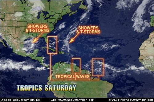
Click here for July 2006 Hurricane and Severe Weather Outlook.
Here is some commentary on the July 2-4, 2006 forecast. This forecast was prepared between Nov. 16-28, 2005.
July 2-4Forecast: The tropics may begin to rumble as planetary indicators off the coast of Veracruz, Mexico suggest the possibility of tropical storm formation there.The Arklatex region shows signs of severe weather as moisture from the Gulf of Mexico is pumped into the area.
Results
The July 1, 2006 Accuweather Map above shows the development of thunderstorms and showers off the coast of Veracruz, Mexico. The Mexican Weather Bureau reported the following today:
Amplia zona de inestabilidad convectiva frente a las costas de Veracruz y Tamaulipas se asocia con nublados de convección moderada a fuerte, favoreciendo nublados con chubascos, tormentas y vientos fuertes. El sistema avanza hacia el Noroeste y se encuentra en vigilancia debido a su lenta evolución. (A wide area of convective instability off the coasts of Veracruz and Tamaulipas is asscociated with moderate to strong convection favoring showers, storms, and strong winds. The system is moving toward the Northeast and is being watched for further development.) (Rough translation is mine)
Forecast continues...
The Arklatex region shows signs of severe weather as moisture from the Gulf of Mexico is pumped into the area.

The map to the left (courtesy of Accuweather) shows the tropical moisture being pulled up over Texas and Louisiana.
Here Comes The Rain AgainSunday, July 02, 2006 2:18 PM EDT More News The Texas Gulf Coast, which had torrential rain for a couple of days nearly 2 weeks ago, is in for another bout of heavy, flooding rain over the next couple of days. A tropical low pressure system, which was in the southern Gulf of Mexico a couple of days ago, has been drawn northward. Tropical moisture has been concentrating around this system and, as it continues to be pushed northward, this tropical moisture will be shoved ashore into coastal Texas, resulting in heavy, drenching thunderstorms. The overall movement of this system will be slow, so parts of coastal Texas appear to be in for another thorough soaking. This story by AccuWeather.com Meteorologist Gerald Mohler.
Louisiana and Arkansas are in for some wet weather due to this system and other factors.
1213 PM CDT SUN JUL 2 2006
THIS HAZARDOUS WEATHER OUTLOOK IS FOR SOUTHEAST OKLAHOMA...NORTHEASTTEXAS...SOUTHWEST ARKANSAS...NORTHWEST...AND NORTH CENTRAL LOUISIANA.
HEAVY RAINFALL PRODUCING THUNDERSTORMS WILL BE POSSIBLE SOUTHWEST OFA TYLER TEXAS TO POLLOCK LOUISIANA LINE THROUGH TONIGHT. BECAUSE OF THE ANTICIPATED SLOW MOVEMENT OF THE SHOWERS AND THUNDERSTORMS...LOCALIZED HEAVY DOWNPOURS IN THE STRONGER STORMSMAY RESULT IN THE PONDING OF WATER OVER PARTS OF EAST TEXAS THROUGHCENTRAL LOUISIANA.
157 PM CDT SUN JUL 2 2006
THIS HAZARDOUS WEATHER OUTLOOK IS FOR A LARGE PART OF ARKANSAS..
AN ACTIVE WEATHER PATTERN IS SETTING UP FOR MUCH OF THE UPCOMING WEEK... AN UPPER LEVEL LOWPRESSURE SYSTEM OVER TEXAS WILL SEND UP COPIOUS AMOUNTS OFMOISTURE OVER THE MID SOUTH DURING MUCH OF THE WEEK... THE LARGE AMOUNT OF MOISTURE OVER THE AREA WILL INTERACT WITHDAYTIME HEATING AND THE FRONTAL BOUNDARY. THIS WILL ALLOW SCATTEREDTO NUMEROUS SHOWERS AND THUNDERSTORMS TO DEVELOP THROUGH WEDNESDAY.SOME OF THE STORMS MAY PRODUCE HEAVY RAINFALL. ...THE STORMS WILL HAVE THECAPABILITY OF PRODUCING ONE TO TWO INCHES OF RAIN IN A VERY SHORT PERIOD OF TIME.
Sunday, June 18, 2006
July 2006 Hurricane and Severe Weather Outlook
These forecasts were calculated between November 16, 2005 and November 28, 2005.
July 2-4
Forecast: The tropics may begin to rumble as planetary indicators off the coast of Veracruz, Mexico suggest the possibility of tropical storm formation there.
The Arklatex region shows signs of severe weather as moisture from the Gulf of Mexico is pumped into the area.
July 3-5
Forecast: Conditions will be favorable now for tropical storm or hurricane formation over the eastern Pacific around 120 West Longitude and 17 North Latitude.
Thunderstorms will roam the western U.S. into the Rockies.
July 4-6
Forecast: The extreme southern portions of Mexico in and around the states of Chiapas and Tabasco are in line for tropical activity. Severe weather potential, which may indicate tropical storm or hurricane formation also exists over the Baja California.
In the Atlantic, the area east of the Lesser Antilles around 58 West Longitude and 16 North Latitude is a vulnerable area for hurricane formation.
Windy and stormy action will center over the western Great Lakes area, and then move eastward over the Mid-Atlantic region. A low pressure area over New England will lead to storms that may reach severe limits as it pushes toward the Canadian Maritimes.
An active weather period continues throughout the West U.S. with severe weather likely over Oregon, Nevada, Utah, and Idaho.
July 6-9
Forecast:
Tropical storm or hurricane formation is likely now east of the Lesser Antilles.
July 8-10
Forecast: A broad area in the Gulf of Mexico stretching from the tip of the Yucatan through the central Gulf may be the focal point for tropical showers to develop into a more organized system.
July 13-15
Forecast:
The development of a tropical system is likely in the southwestern Caribbean. Tropical moisture is indicated as well over the western portions of Cuba and the Florida Peninsula.
July 16-18
Forecast: The west central coast of Mexico near 106 West Longitude and 21 North Latitude shows the potential for severe weather which may be a tropical storm system.
July 17-19
Forecast: The east coast of Mexico also shows potential for tropical storm development. The area in question lies along 98 West and 23 North over the States of Tamaulipas and Veracruz.
On the U.S. mainland, northern and western Texas may see severe storms or tornadoes. Further north, over Minnesota and Wisconsin, dangerous storms and damaging winds will be the attention-getter. This potent weather system then continues toward the east over the Mid-Atlantic region and New England.
July 27-30
Forecast: The inhabitants of the western coast of Mexico around the States of Chihuahua, Michoacan, Jalisco, and Nayarit should prepare for tropical storm development.
It seems the East Coast will be the focal point for severe weather as well. It may be a tropical system affecting the Carolinas and northward. The Upper Mississippi Valley also stands out in regards to strong winds.
July 31-August 2
Forecast: Tropical storm or hurricane development is now likely east of the Lesser Antilles.
New England is also slated for more severe weather now.
July 2-4
Forecast: The tropics may begin to rumble as planetary indicators off the coast of Veracruz, Mexico suggest the possibility of tropical storm formation there.
The Arklatex region shows signs of severe weather as moisture from the Gulf of Mexico is pumped into the area.
July 3-5
Forecast: Conditions will be favorable now for tropical storm or hurricane formation over the eastern Pacific around 120 West Longitude and 17 North Latitude.
Thunderstorms will roam the western U.S. into the Rockies.
July 4-6
Forecast: The extreme southern portions of Mexico in and around the states of Chiapas and Tabasco are in line for tropical activity. Severe weather potential, which may indicate tropical storm or hurricane formation also exists over the Baja California.
In the Atlantic, the area east of the Lesser Antilles around 58 West Longitude and 16 North Latitude is a vulnerable area for hurricane formation.
Windy and stormy action will center over the western Great Lakes area, and then move eastward over the Mid-Atlantic region. A low pressure area over New England will lead to storms that may reach severe limits as it pushes toward the Canadian Maritimes.
An active weather period continues throughout the West U.S. with severe weather likely over Oregon, Nevada, Utah, and Idaho.
July 6-9
Forecast:
Tropical storm or hurricane formation is likely now east of the Lesser Antilles.
July 8-10
Forecast: A broad area in the Gulf of Mexico stretching from the tip of the Yucatan through the central Gulf may be the focal point for tropical showers to develop into a more organized system.
July 13-15
Forecast:
The development of a tropical system is likely in the southwestern Caribbean. Tropical moisture is indicated as well over the western portions of Cuba and the Florida Peninsula.
July 16-18
Forecast: The west central coast of Mexico near 106 West Longitude and 21 North Latitude shows the potential for severe weather which may be a tropical storm system.
July 17-19
Forecast: The east coast of Mexico also shows potential for tropical storm development. The area in question lies along 98 West and 23 North over the States of Tamaulipas and Veracruz.
On the U.S. mainland, northern and western Texas may see severe storms or tornadoes. Further north, over Minnesota and Wisconsin, dangerous storms and damaging winds will be the attention-getter. This potent weather system then continues toward the east over the Mid-Atlantic region and New England.
July 27-30
Forecast: The inhabitants of the western coast of Mexico around the States of Chihuahua, Michoacan, Jalisco, and Nayarit should prepare for tropical storm development.
It seems the East Coast will be the focal point for severe weather as well. It may be a tropical system affecting the Carolinas and northward. The Upper Mississippi Valley also stands out in regards to strong winds.
July 31-August 2
Forecast: Tropical storm or hurricane development is now likely east of the Lesser Antilles.
New England is also slated for more severe weather now.
Wednesday, May 31, 2006
May 2006 Forecast Results 80 Percent Accuracy
May 2006 Forecast Results
Forecast
May 4-6, 2006: Fair and dry conditions with a lower range of temperatures are indicated for the area after a storm system hits around the 3rd.
Results
May 3, 2006: The Weather Channel
Precipitation will plod into western portions of the Northeast Thursday (4th) at the same time a wet weather system that has plagued New England over the past couple of days slinks away into the Atlantic.
May 5, 2006: National Weather Service
REGIONAL WEATHER SUMMARY FOR NEW YORK AND VERMON
TNATIONAL WEATHER SERVICE
ALBANY NY
825 PM EDT FRI MAY 05 2006
SYNOPSIS...DRY NORTHWEST FLOW WILL DOMINATE THE WEATHER TONIGHT.TOMORROW... TEMPERATURES WILL COOL TOMORROW...
WEATHER SUMMARY FOR SOUTHEAST NEW YORK...NORTHEAST NEW JERSEY AND SOUTHERN CONNECTICUT
NATIONAL WEATHER SERVICE
UPTON NY
330 PM EDT FRI MAY 5 2006
MOSTLY CLEAR SKIES AND LIGHT NORTHERLY WINDS WILL KEEPTEMPERATURES A FEW DEGREES COOLER THAN NORMAL SATURDAY (6th)NIGHT.
Forecast
May 6-8, 2006: The arrival of a colder air mass over the Northeast will result in precipitation.
May 6, 2006: The Weather Channel
Northeast
Low pressure aloft over eastern Canada will keep showers in the Saturday forecast across northern sections of New York and New England. Colder air will also slide into the area.
HAZARDOUS WEATHER OUTLOOK
NATIONAL WEATHER SERVICE
BUFFALO NY
426 AM EDT SAT MAY 6 2006A
FROST ADVISORY IS IN EFFECT FROM 4 AM TO 8 AM SUNDAY.THE COMBINATION OF CLEARING SKIES AND DIMINISHING WINDS WILL ALLOW
TEMPERATURES TO DIP INTO THE LOWER AND MID 30S TONIGHT.
May 6, 2006: Accuweather
The east...will be stuck in a cool flow with temperatures in the 50s. This will be the result of a weak cool front dropping down from Canada, heading toward the Northeast.
Forecast:
May 10-12, 2006: Winds over the Northeast blow out of the south now elevating temperatures and bringing a chance of rain.
Results:
May 10, 2006: The Weather Channel
Northeast
Heavy rain and thunderstorms will develop over the mid-Atlantic states Thursday (May 11th) as a cold front slows in its eastward progress. A few of the storms over Virginia, eastern West Virginia and western Maryland could turn severe. Elsewhere in the Northeast, cloudiness and showers will prevail. Temperatures will be generally near to below mid-spring means with highs ranging from the 50s in much of eastern New England to the 70s in a good chunk of Virginia. South to southeast winds will become rather gusty in many areas in response to an unseasonably strong storm churning over the Great Lakes.
Forecast:
May 16-18, 2006: A cold front with its attendant cloudiness and precipitation
will offer a break from relatively high temperatures.
Results:
May 15, 2006: The Weather Channel
Northeast
…Rain will wind down overnight but more showers are on tap for New England on Tuesday (May 16th) as an area of low pressure aloft moves toward the area. Much of the Northeast will have to deal with these showers and even more rain is on tap for later in the week. Temperatures will be below average for mid-May…
May 17, 2006: The Weather Channel
Northeast
Another storm moves into the Northeast Thursday (May 18th) and hangs around into early Saturday…Eastern sections of the region should have a fairly mild day before the storms Thursday with high temperatures in the upper 60s to middle 70s. Western sections of the Northeast will already be experiencing the cooler temperatures behind the cold front with highs holding in the 50s to very low 60s.
Forecast:
May 22-23, 2006: Southerly winds will transport heat and humidity into the Northeast and New England resulting in atmospheric disturbance.
Results:
May 22, 2006: The Weather Channel
Northeast
Breezy and slightly cooler-than-average conditions will prevail again in the Northeast tomorrow (May 23rd). And although there'll be a few showers around, they'll be limited to northern New England and the Adirondacks. Frost may greet early risers in parts of New York state, Pennsylvania, northern New Jersey, western Maryland and West Virginia, but afternoon readings throughout the region will push into 50s, 60s and 70s, north to south.
Forecast:
May 26-27, 2006: A storm system headed for the Canadian Maritimes will drop rain and kick up windy conditions over the Northeast and New England.
Results:
REGIONAL WEATHER SUMMARY FOR NEW YORK AND VERMONT
NATIONAL WEATHER SERVICE ALBANY NY
822 PM EDT FRI MAY 26 2006
SYNOPSIS, A LOW PRESSURE SYSTEM WILL MOVE ACROSS OUR REGION THIS EVENING AND CONTINUE EAST INTO NEW ENGLAND OVERNIGHT. SHOWERS AND THUNDERSTORMS MAY BE EXPECTED WITH THE FRONTAL PASSAGE.
WEATHER SUMMARY FOR SOUTHEAST NEW YORK...
NORTHEAST NEW JERSEY AND SOUTHERN CONNECTICUT
NATIONAL WEATHER SERVICE UPTON NY
330 PM EDT FRI MAY 26 2006
...SUMMERLIKE WEATHER ON TAP AFTER A BOUT OF ROUGH WEATHER...
SCATTERED SHOWERS AND THUNDERSTORMS WILL CONTINUE TO AFFECT THE REGION INTO THE EARLY EVENING HOURS. SOME OF THESE STORMS MAY PRODUCE FREQUENT LIGHTNING...HEAVY RAINFALL AND GUSTY WINDS.
Forecast:
May 30-June 1, 2006: Warmth makes its way through the eastern U.S. only to trigger stormy conditions from the Mid-Atlantic region to the Northeast. If not enough moisture is available to result in precipitation, wind will be the salient feature.
Results:
May 29, 2006: The Weather Channel
Northeast
New England and eastern New York will cool off a bit tomorrow as a cold front pushes southwestward from Canada. Hot weather, however, will grip the remainder of the Northeast…Scattered, or maybe only isolated, thunderstorms will accompany the heat and focus along the cold front. Thus, much of eastern New England, Virginia and West Virginia may remain free of precipitation.
May 30, 2006: The Weather Channel
Northeast
Warm, humid air will blanket the interior Northeast tomorrow, leading to scattered showers and thunderstorms, mainly later in the day…Temperatures are expected be near to somewhat above end-of-May means with highs in the 70s in New England, eastern New York, much of New Jersey and the Delmarva Peninsula, and the 80s elsewhere.
Forecast
May 4-6, 2006: Fair and dry conditions with a lower range of temperatures are indicated for the area after a storm system hits around the 3rd.
Results
May 3, 2006: The Weather Channel
Precipitation will plod into western portions of the Northeast Thursday (4th) at the same time a wet weather system that has plagued New England over the past couple of days slinks away into the Atlantic.
May 5, 2006: National Weather Service
REGIONAL WEATHER SUMMARY FOR NEW YORK AND VERMON
TNATIONAL WEATHER SERVICE
ALBANY NY
825 PM EDT FRI MAY 05 2006
SYNOPSIS...DRY NORTHWEST FLOW WILL DOMINATE THE WEATHER TONIGHT.TOMORROW... TEMPERATURES WILL COOL TOMORROW...
WEATHER SUMMARY FOR SOUTHEAST NEW YORK...NORTHEAST NEW JERSEY AND SOUTHERN CONNECTICUT
NATIONAL WEATHER SERVICE
UPTON NY
330 PM EDT FRI MAY 5 2006
MOSTLY CLEAR SKIES AND LIGHT NORTHERLY WINDS WILL KEEPTEMPERATURES A FEW DEGREES COOLER THAN NORMAL SATURDAY (6th)NIGHT.
Forecast
May 6-8, 2006: The arrival of a colder air mass over the Northeast will result in precipitation.
May 6, 2006: The Weather Channel
Northeast
Low pressure aloft over eastern Canada will keep showers in the Saturday forecast across northern sections of New York and New England. Colder air will also slide into the area.
HAZARDOUS WEATHER OUTLOOK
NATIONAL WEATHER SERVICE
BUFFALO NY
426 AM EDT SAT MAY 6 2006A
FROST ADVISORY IS IN EFFECT FROM 4 AM TO 8 AM SUNDAY.THE COMBINATION OF CLEARING SKIES AND DIMINISHING WINDS WILL ALLOW
TEMPERATURES TO DIP INTO THE LOWER AND MID 30S TONIGHT.
May 6, 2006: Accuweather
The east...will be stuck in a cool flow with temperatures in the 50s. This will be the result of a weak cool front dropping down from Canada, heading toward the Northeast.
Forecast:
May 10-12, 2006: Winds over the Northeast blow out of the south now elevating temperatures and bringing a chance of rain.
Results:
May 10, 2006: The Weather Channel
Northeast
Heavy rain and thunderstorms will develop over the mid-Atlantic states Thursday (May 11th) as a cold front slows in its eastward progress. A few of the storms over Virginia, eastern West Virginia and western Maryland could turn severe. Elsewhere in the Northeast, cloudiness and showers will prevail. Temperatures will be generally near to below mid-spring means with highs ranging from the 50s in much of eastern New England to the 70s in a good chunk of Virginia. South to southeast winds will become rather gusty in many areas in response to an unseasonably strong storm churning over the Great Lakes.
Forecast:
May 16-18, 2006: A cold front with its attendant cloudiness and precipitation
will offer a break from relatively high temperatures.
Results:
May 15, 2006: The Weather Channel
Northeast
…Rain will wind down overnight but more showers are on tap for New England on Tuesday (May 16th) as an area of low pressure aloft moves toward the area. Much of the Northeast will have to deal with these showers and even more rain is on tap for later in the week. Temperatures will be below average for mid-May…
May 17, 2006: The Weather Channel
Northeast
Another storm moves into the Northeast Thursday (May 18th) and hangs around into early Saturday…Eastern sections of the region should have a fairly mild day before the storms Thursday with high temperatures in the upper 60s to middle 70s. Western sections of the Northeast will already be experiencing the cooler temperatures behind the cold front with highs holding in the 50s to very low 60s.
Forecast:
May 22-23, 2006: Southerly winds will transport heat and humidity into the Northeast and New England resulting in atmospheric disturbance.
Results:
May 22, 2006: The Weather Channel
Northeast
Breezy and slightly cooler-than-average conditions will prevail again in the Northeast tomorrow (May 23rd). And although there'll be a few showers around, they'll be limited to northern New England and the Adirondacks. Frost may greet early risers in parts of New York state, Pennsylvania, northern New Jersey, western Maryland and West Virginia, but afternoon readings throughout the region will push into 50s, 60s and 70s, north to south.
Forecast:
May 26-27, 2006: A storm system headed for the Canadian Maritimes will drop rain and kick up windy conditions over the Northeast and New England.
Results:
REGIONAL WEATHER SUMMARY FOR NEW YORK AND VERMONT
NATIONAL WEATHER SERVICE ALBANY NY
822 PM EDT FRI MAY 26 2006
SYNOPSIS, A LOW PRESSURE SYSTEM WILL MOVE ACROSS OUR REGION THIS EVENING AND CONTINUE EAST INTO NEW ENGLAND OVERNIGHT. SHOWERS AND THUNDERSTORMS MAY BE EXPECTED WITH THE FRONTAL PASSAGE.
WEATHER SUMMARY FOR SOUTHEAST NEW YORK...
NORTHEAST NEW JERSEY AND SOUTHERN CONNECTICUT
NATIONAL WEATHER SERVICE UPTON NY
330 PM EDT FRI MAY 26 2006
...SUMMERLIKE WEATHER ON TAP AFTER A BOUT OF ROUGH WEATHER...
SCATTERED SHOWERS AND THUNDERSTORMS WILL CONTINUE TO AFFECT THE REGION INTO THE EARLY EVENING HOURS. SOME OF THESE STORMS MAY PRODUCE FREQUENT LIGHTNING...HEAVY RAINFALL AND GUSTY WINDS.
Forecast:
May 30-June 1, 2006: Warmth makes its way through the eastern U.S. only to trigger stormy conditions from the Mid-Atlantic region to the Northeast. If not enough moisture is available to result in precipitation, wind will be the salient feature.
Results:
May 29, 2006: The Weather Channel
Northeast
New England and eastern New York will cool off a bit tomorrow as a cold front pushes southwestward from Canada. Hot weather, however, will grip the remainder of the Northeast…Scattered, or maybe only isolated, thunderstorms will accompany the heat and focus along the cold front. Thus, much of eastern New England, Virginia and West Virginia may remain free of precipitation.
May 30, 2006: The Weather Channel
Northeast
Warm, humid air will blanket the interior Northeast tomorrow, leading to scattered showers and thunderstorms, mainly later in the day…Temperatures are expected be near to somewhat above end-of-May means with highs in the 70s in New England, eastern New York, much of New Jersey and the Delmarva Peninsula, and the 80s elsewhere.
Monday, May 08, 2006
Some Results of May's Long-Range Weather Forecasts
On April 8th, 2006, May's long-range weather forecasts for the Northeast U.S. were posted. Here are some results of the first of these forecasts.
Click here for May 2006 Long-Range Forecasts.
Forecast
May 4-6, 2006: Fair and dry conditions with a lower range of temperatures are indicated for the area after a storm system hits around the 3rd.
Results
May 3, 2006: The Weather Channel
Precipitation will plod into western portions of the Northeast Thursday (4th) at the same time a wet weather system that has plagued New England over the past couple of days slinks away into the Atlantic.
May 5, 2006: National Weather Service
REGIONAL WEATHER SUMMARY FOR NEW YORK AND VERMON
TNATIONAL WEATHER SERVICE
ALBANY NY
825 PM EDT FRI MAY 05 2006
SYNOPSIS...DRY NORTHWEST FLOW WILL DOMINATE THE WEATHER TONIGHT.TOMORROW... TEMPERATURES WILL COOL TOMORROW...
WEATHER SUMMARY FOR SOUTHEAST NEW YORK...NORTHEAST NEW JERSEY AND SOUTHERN CONNECTICUT
NATIONAL WEATHER SERVICE
UPTON NY
330 PM EDT FRI MAY 5 2006
MOSTLY CLEAR SKIES AND LIGHT NORTHERLY WINDS WILL KEEPTEMPERATURES A FEW DEGREES COOLER THAN NORMAL SATURDAY (6th)NIGHT.
Forecast
May 6-8, 2006: The arrival of a colder air mass over the Northeast will result in precipitation.
May 6, 2006: The Weather Channel
Northeast
Low pressure aloft over eastern Canada will keep showers in the Saturday forecast across northern sections of New York and New England. Colder air will also slide into the area.
HAZARDOUS WEATHER OUTLOOK
NATIONAL WEATHER SERVICE
BUFFALO NY
426 AM EDT SAT MAY 6 2006A
FROST ADVISORY IS IN EFFECT FROM 4 AM TO 8 AM SUNDAY.THE COMBINATION OF CLEARING SKIES AND DIMINISHING WINDS WILL ALLOW
TEMPERATURES TO DIP INTO THE LOWER AND MID 30S TONIGHT.
May 6, 2006: Accuweather
The east...will be stuck in a cool flow with temperatures in the 50s. This will be the result of a weak cool front dropping down from Canada, heading toward the Northeast.
Click here for May 2006 Long-Range Forecasts.
Forecast
May 4-6, 2006: Fair and dry conditions with a lower range of temperatures are indicated for the area after a storm system hits around the 3rd.
Results
May 3, 2006: The Weather Channel
Precipitation will plod into western portions of the Northeast Thursday (4th) at the same time a wet weather system that has plagued New England over the past couple of days slinks away into the Atlantic.
May 5, 2006: National Weather Service
REGIONAL WEATHER SUMMARY FOR NEW YORK AND VERMON
TNATIONAL WEATHER SERVICE
ALBANY NY
825 PM EDT FRI MAY 05 2006
SYNOPSIS...DRY NORTHWEST FLOW WILL DOMINATE THE WEATHER TONIGHT.TOMORROW... TEMPERATURES WILL COOL TOMORROW...
WEATHER SUMMARY FOR SOUTHEAST NEW YORK...NORTHEAST NEW JERSEY AND SOUTHERN CONNECTICUT
NATIONAL WEATHER SERVICE
UPTON NY
330 PM EDT FRI MAY 5 2006
MOSTLY CLEAR SKIES AND LIGHT NORTHERLY WINDS WILL KEEPTEMPERATURES A FEW DEGREES COOLER THAN NORMAL SATURDAY (6th)NIGHT.
Forecast
May 6-8, 2006: The arrival of a colder air mass over the Northeast will result in precipitation.
May 6, 2006: The Weather Channel
Northeast
Low pressure aloft over eastern Canada will keep showers in the Saturday forecast across northern sections of New York and New England. Colder air will also slide into the area.
HAZARDOUS WEATHER OUTLOOK
NATIONAL WEATHER SERVICE
BUFFALO NY
426 AM EDT SAT MAY 6 2006A
FROST ADVISORY IS IN EFFECT FROM 4 AM TO 8 AM SUNDAY.THE COMBINATION OF CLEARING SKIES AND DIMINISHING WINDS WILL ALLOW
TEMPERATURES TO DIP INTO THE LOWER AND MID 30S TONIGHT.
May 6, 2006: Accuweather
The east...will be stuck in a cool flow with temperatures in the 50s. This will be the result of a weak cool front dropping down from Canada, heading toward the Northeast.
Saturday, April 15, 2006
Some History of Astro-Meteorology
Click here for May 2006 long-range weather forecasts.
The first known work on weather and the atmosphere was The Meteorologica by the Greek philosopher-scientist Aristotle (384 B.C. to 322 B.C.). His pupil, Theophrastus expanded this early treatise in two works “On Winds” and “On the Signs of Rain, Winds, Storms, and Fair Weather.”
These were the sole authorities on meteorology until scientific investigations began in the 17th Century. (Ptolemy’s Tetrabiblos, 152 A.D. quoted brief excerpts).
In 1686, Dr. J. Goad’s Astro-meteorologica, based on 39 years of his own astro-weather observations and correlations, was published in London. Until the end of the 19th Century this text was the leading authority on the subject. It includes a transcript of astronomer Johannes Kepler’s diary of astro-weather observations from June 28, 1617 to August 9, 1629. Here Kepler expounded some of his theories relating planetary phenomena to atmospheric changes. It is a matter of historical record that he attained recognition for his remarkably accurate long-range weather forecasting long before advancing his laws of planetary motion. Kepler’s “Mysterium Cosmographicum” is a fully documented record of his work from 1602 to 1629. Some scientists who have written disparagingly of the renowned Kepler’s interest in correlating planetary phenomena to terrestrial events have rendered a disservice to the progress of science.
Critically tested astro-weather forecasts during the last century, ventured for various parts of the world more than a year in advance, support and confirm Kepler’s theories. He discovered that additional magnetic angles of 30, 45, 135 and 150 degrees between celestial bodies synchronized perfectly with atmospheric reactions.
Commander R. J. Morrison of the Royal Navy, publisher of the world known Zadkiel’s Almanac more than a century ago, further refined his predecessors’ discoveries with a more modern scientific approach.
Morrison’s successor, Dr. Alfred J. Pearce (1840-1923), continued the Almanac from 1876 for forty years. He also published his “Weather Guide” in London during 186r, The Science of the Stars in 1881, and completed a magnum opus—his Textbook Vol. II in 1889. In this expanded work, Pearce evolved new techniques from his own observations with detailed instructions in the method. He cited case histories and voluminous data to support and rationalize the theory of astro-meteorology.
Observations of solar radiation and sunspots will never lead to the discovery of the laws which regulate the weather. The atmosphere is often liable to unusual and long continued impressions, and these are induced by planetary action on the earth as well as on the Sun. Based on many years of specialized experience with astro-meteorology, we are convinced that to abandon this research is to render the discovery of the laws which regulate the weather, hopeless.
G.J. McCormack
1965
The first known work on weather and the atmosphere was The Meteorologica by the Greek philosopher-scientist Aristotle (384 B.C. to 322 B.C.). His pupil, Theophrastus expanded this early treatise in two works “On Winds” and “On the Signs of Rain, Winds, Storms, and Fair Weather.”
These were the sole authorities on meteorology until scientific investigations began in the 17th Century. (Ptolemy’s Tetrabiblos, 152 A.D. quoted brief excerpts).
In 1686, Dr. J. Goad’s Astro-meteorologica, based on 39 years of his own astro-weather observations and correlations, was published in London. Until the end of the 19th Century this text was the leading authority on the subject. It includes a transcript of astronomer Johannes Kepler’s diary of astro-weather observations from June 28, 1617 to August 9, 1629. Here Kepler expounded some of his theories relating planetary phenomena to atmospheric changes. It is a matter of historical record that he attained recognition for his remarkably accurate long-range weather forecasting long before advancing his laws of planetary motion. Kepler’s “Mysterium Cosmographicum” is a fully documented record of his work from 1602 to 1629. Some scientists who have written disparagingly of the renowned Kepler’s interest in correlating planetary phenomena to terrestrial events have rendered a disservice to the progress of science.
Critically tested astro-weather forecasts during the last century, ventured for various parts of the world more than a year in advance, support and confirm Kepler’s theories. He discovered that additional magnetic angles of 30, 45, 135 and 150 degrees between celestial bodies synchronized perfectly with atmospheric reactions.
Commander R. J. Morrison of the Royal Navy, publisher of the world known Zadkiel’s Almanac more than a century ago, further refined his predecessors’ discoveries with a more modern scientific approach.
Morrison’s successor, Dr. Alfred J. Pearce (1840-1923), continued the Almanac from 1876 for forty years. He also published his “Weather Guide” in London during 186r, The Science of the Stars in 1881, and completed a magnum opus—his Textbook Vol. II in 1889. In this expanded work, Pearce evolved new techniques from his own observations with detailed instructions in the method. He cited case histories and voluminous data to support and rationalize the theory of astro-meteorology.
Observations of solar radiation and sunspots will never lead to the discovery of the laws which regulate the weather. The atmosphere is often liable to unusual and long continued impressions, and these are induced by planetary action on the earth as well as on the Sun. Based on many years of specialized experience with astro-meteorology, we are convinced that to abandon this research is to render the discovery of the laws which regulate the weather, hopeless.
G.J. McCormack
1965
Saturday, April 08, 2006
May 2006 Long-Range Weather Forecasts
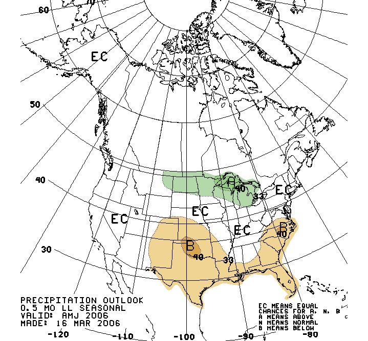
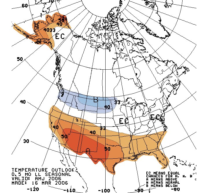
The two maps above show the “Three Month Outlook” for April, May and June 2006 from the Climate Prediction Center. They were prepared in March 2006. The map on the top shows the precipitation outlook, and the map on the bottom shows the temperature outlook.
On the precipitation map, the areas where precipitation may be above average are marked by an "A". The areas where precipitation is forecast to be below average are marked with a "B". The areas marked "EC" are areas where there are equal chances of it being above or below average, or according to their own definition "the probability of the most likely category cannot be determined." The same three A, B, and EC designations apply to the temperature map.
If we look at the Northeast U.S., we see that Climate Prediction Center could not determine what to forecast regarding temperature and precipitation. By following Kepler’s long-range forecast method, however, we can make some long-range predictions that give us much more information regarding what the Northeast might expect during this time period. Since this article would grow too long if we were to list all the information this method might provide, we shall limit our observations to a few of the more outstanding weather patterns that will affect the Northeast U.S. during the month of May. Kepler's method can provide us with three key pieces of information:
1) the time the weather pattern will manifest
2) the type of weather
3) the location
Forecasts for the Northeast U.S. and surruounding areas:
May 4-6, 2006: Fair and dry conditions with a lower range of temperatures are indicated for the area after a storm system hits around the 3rd.
May 6-8, 2006: The arrival of a colder air mass over the Northeast will result in precipitation.
May 10-12, 2006: Winds over the Northeast blow out of the south now elevating temperatures and bringing a chance of rain.
May 16-18, 2006: A cold front with its attendant cloudiness and precipitation will offer a break from relatively high temperatures.
May 22-23, 2006: Southerly winds will transport heat and humidity into the the Northeast and New England resulting in atmospheric disturbance.
May 26-27, 2006: A storm system headed for the Canadian Maritimes will drop rain and kick up windy conditions over the Northeast and New England.
May 30-June 1, 2006: Warmth makes its way through the eastern U.S. only to trigger stormy conditions from the Mid-Atlantic region to the Northeast. If not enough moisture is available to result in precipitation, wind will be the salient feature.
Friday, March 10, 2006
Saxby's Weather System
Saxby's Weather System was publised in 1864. The author, Stephen Martin Saxby, presented his case for lunar influence on earthly weather. He summed things up in the following words:
"I found that the moon never crosses the earth's equator or reaches her poisition of stitial colure (maximum declination north or south of the equator), without a marked disturbance of the atmosphere occurring at the same period."
What kind of weather did Saxby expect when the moon reached theses key positions? "...such changes most commonly are accompanied either by strong winds, gales, sudden frosts, sudden thaw, sudden calms, or other certain interruptions of the weather, according to the season."
Saxby realized that this "key" was just part of the weather picture and could not pinpoint the places where such weather phenomena would take place when he stated "It is too much to expect of me that I can define the terrestrial limits of any results which at certain times may present themselves under lunar influences...All I can do at present (or at least all I at present feel justified in declaring, with some exceptions) is that certain periods named in my lists will be times of change."
Saxby considered that these atmospheric changes could take place over a four day period i.e. the day before, the day during, and until two days after the aforementioned lunar positions.
Of course, we know that much more goes into forming our weather than that, but Saxby was on to something. It seems that powerful weather systems are somehow linked to these times. Out of curiosity, I picked the dates of some major storms and hurricanes and checked the lunar positions. All of them coincided with Saxby's allowable window of influence. Here they are:
Hurricane Andrew
August 24, 1992
Moon at maximum north declination on August 22 1992
Hurricane Katrina
August 29, 2005
Moon at maximum north declination on August 28, 2005
Tsunami
December 26, 2004
Moon at maximum north declination and at Full Moon December 26, 2004
Blizzard of '93
March 12-13, 1993
Moon at maximum south declination on March 14, 1993
Hurricane Wilma pounds the Yucatan Peninsula
October 21-23, 2005
Moon at maximum north declination October 22, 2005
"I found that the moon never crosses the earth's equator or reaches her poisition of stitial colure (maximum declination north or south of the equator), without a marked disturbance of the atmosphere occurring at the same period."
What kind of weather did Saxby expect when the moon reached theses key positions? "...such changes most commonly are accompanied either by strong winds, gales, sudden frosts, sudden thaw, sudden calms, or other certain interruptions of the weather, according to the season."
Saxby realized that this "key" was just part of the weather picture and could not pinpoint the places where such weather phenomena would take place when he stated "It is too much to expect of me that I can define the terrestrial limits of any results which at certain times may present themselves under lunar influences...All I can do at present (or at least all I at present feel justified in declaring, with some exceptions) is that certain periods named in my lists will be times of change."
Saxby considered that these atmospheric changes could take place over a four day period i.e. the day before, the day during, and until two days after the aforementioned lunar positions.
Of course, we know that much more goes into forming our weather than that, but Saxby was on to something. It seems that powerful weather systems are somehow linked to these times. Out of curiosity, I picked the dates of some major storms and hurricanes and checked the lunar positions. All of them coincided with Saxby's allowable window of influence. Here they are:
Hurricane Andrew
August 24, 1992
Moon at maximum north declination on August 22 1992
Hurricane Katrina
August 29, 2005
Moon at maximum north declination on August 28, 2005
Tsunami
December 26, 2004
Moon at maximum north declination and at Full Moon December 26, 2004
Blizzard of '93
March 12-13, 1993
Moon at maximum south declination on March 14, 1993
Hurricane Wilma pounds the Yucatan Peninsula
October 21-23, 2005
Moon at maximum north declination October 22, 2005
Saturday, March 04, 2006
March 1-4, 2006 Forecast Results
The Weather Alternative bases its forecasts on Johannes Kepler's long-range forecast system. Planetary cycles are at the heart of Kepler's method and enable its practitioners to venture forecasts much further into the future than conventional meteorology can at present. The following forecast, posted on February 16, 2006, and its results are an example of the accuracy that can be attained by this method.
Having worked with this system for a number of years, I never cease to be amazed at the beauty and the "down-to-earth" practicality that its designer bestowed upon the heavenly bodies. The members of our solar system no longer appear to be unrelated and meaningless masses of rock and gas circling the sun as science sometimes leaves us feeling. But God has given purpose to the planets and equipped his offspring with a built-in, environmentally safe, long-range weather forecasting tool for our service.
Forecast:
March Comes in Like a Lion
March 1-4, 2006:
A major winter storm will roar into the Pacific Northwest and Northern California on gusty winds. Its trek through the Great Basin and Rockies will provoke falling temperatures and prompt winter storm warnings and high wind advisories.
Results
Accuweather displayed the following weather map on Tuesday, February 28th.
Having worked with this system for a number of years, I never cease to be amazed at the beauty and the "down-to-earth" practicality that its designer bestowed upon the heavenly bodies. The members of our solar system no longer appear to be unrelated and meaningless masses of rock and gas circling the sun as science sometimes leaves us feeling. But God has given purpose to the planets and equipped his offspring with a built-in, environmentally safe, long-range weather forecasting tool for our service.
Forecast:
March Comes in Like a Lion
March 1-4, 2006:
A major winter storm will roar into the Pacific Northwest and Northern California on gusty winds. Its trek through the Great Basin and Rockies will provoke falling temperatures and prompt winter storm warnings and high wind advisories.
Results
Accuweather displayed the following weather map on Tuesday, February 28th.
 Graphic courtesy of accuweather.com
February 28, 2006
The Weather Channel
By afternoon, western Washington, western Oregon and northern California will come under assault from a Gulf of Alaska storm as rain and wind spread eastward. Late tomorrow and tomorrow night, the heaviest rains and mountain snows will smack southwestern Oregon and northern California while strong, gusty winds lay into the Oregon and northern California coasts.
March 1, 2006
The Weather Channel
Many in the West will be in between systems today, as one spreads showers and snow through the central and southern Rockies, while the next system targets the Northwest. A few showers and higher elevation snow will fall, especially across the Colorado Rockies.
March 3, 2006
The Weather Channel
A new western storm system will take aim on California today.
Forecast:
An intense cold front will usher in cold Canadian air that will lower temperatures, and rev up winds that will result in strong storms over the Plains.
Results
Accuweather displayed the following weather map on February 28, 2006.
 Graphic courtesy of accuweather.com
March 1, 2006
Accuweather
The combination of the storm system moving east and high pressure building over the central Rockies is going to create strong winds across the Plains States. AccuWeather.com is forecasting wind speeds will average 15-25 mph, but there will be gusts of up to 35 mph, and some areas could also see experience gusts topping 50 mph on Thursday afternoon (March 2nd).
March 2, 2006
The Weather Channel
Midwest
With cool high pressure settling over the region, high temperatures today will be noticeably cooler; in some cases about 15 to 20 degrees cooler.
Forecast:
A significant storm will also batter the Northeast and New England as warm, moist air is pulled up over the region, particularly around the 4th. Due to the incursion of southerly moisture, precipitation may mostly manifest as rain.
Results
March 2, 2006
Accuweather
WINTER STORM CREATES HAVOC IN NORTHAST
The late-winter storm rolling through the Northeast has closed schools and caused travel problems.
Senior Meteorologist Gerald Mohler...is forecasting today's target for the heaviest snowfall will be extreme northeastern Pennsylvania and the southern tier of New York state, with 8 to 9 inches of snow likely to fall in that area.
According to Mohler, the warm air from the South has pushed well into the Northeast, keeping much of the precipitation in this system in the form of rain, freezing rain and sleet. The snow is falling across north-central Pennsylvania and central New York, while the greater Philadelphia area is receiving mostly freezing rain.
Mohler is forecasting temperatures across the southern edge of the storm will push above the freezing mark by mid-morning, and the precipitation will change to all rain.
March 2, 2006
Weather Map courtesy of the Weather Channel
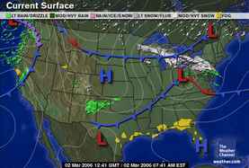
March 4, 2006
The Weather Channel
Northeast
A strong and persistent area of low pressure in the Maritimes of Canada will keep a cold northwesterly flow of air across the region. Winds may gust from 35 to 40 mph at times. Wind chills throughout the region will hover in the teens and twenties this afternoon. Moisture moving back around the Maritime low will back down through Quebec into parts of Vermont and New Hampshire and several inches of snow may accumulate. A heavy snow warning is in place for northern Vermont until Sunday morning. Meanwhile, snow showers may fall in areas near Lakes Erie and Ontario.
Subscribe to:
Posts (Atom)